
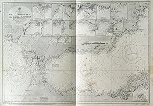
GIBRALTAR TO ALICANTE / CAPE SPARTEL TO CAPE FERRAT . Large sea chart from Spanish and French Government Charts to 1877. 15 small inset charts of Spanish harbours. First published at the Admiralty 1878 under the Superintendence of Captain F. J. Evans, and now with latest corrections by the
Admiralty Charts.
Verlag: Admiralty 1957
Karte
Zustand: Fine
Verk�ufer Garwood & Voigt, Sevenoaks, Vereinigtes K�nigreich
Verk�uferbewertung 5 von 5 Sternen
![]()
AbeBooks-Verk�ufer seit 25. November 2013