
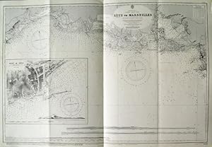
SČTE TO MARSEILLES . Sea chart of the coast between Sčte and Marseille (Camargue) with a large inset chart of the Port of Sčte, compiled from French Government Charts to 1912. First published at the Admiralty 1894 under the Superintendence of Captain W. J. L. Wharton, and now with small corrections by the
Admiralty Charts.
Verlag: Admiralty 1957
Karte
Zustand: Fine
Verkäufer Garwood & Voigt, Sevenoaks, Vereinigtes Königreich
Verkäuferbewertung 5 von 5 Sternen
![]()
AbeBooks-Verkäufer seit 25. November 2013