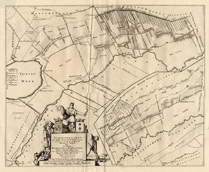
Antique Map-SCHOOTERLAND-NETHERLANDS-Halma-1718
Verkäufer ThePrintsCollector, Zeeland, Niederlande
Verkäuferbewertung 5 von 5 Sternen
AbeBooks-Verkäufer seit 3. April 2017
Verkäufer ThePrintsCollector, Zeeland, Niederlande
Verkäuferbewertung 5 von 5 Sternen
AbeBooks-Verkäufer seit 3. April 2017
Beschreibung
Map: Schooterlandt, de vijfde Grietenije van Zevenwolden - This regional map of the Schooterlandt Grietenij, part of the Province of Friesland, The Netherlands shows the situation around 1718. Grietenijen later turned into the present day towns. On this detailed map you will find: Oudeschoot, Rotstergaast, Nye Schoot, Nieuweschoot, Olde Schoot, Oudeschoot, Tjieuke Meer, Rottum, and much more detailed information. Copperplate engraving on verge type hand laid paper with watermark. Description: This detailed original antique map originates from: 'Uitbeelding der Heerlijkheit Friesland '', by B. Schotanus a Sterringa and published by F. Halma in 1718. This Atlas is considered the best atlas of Friesland, the Netherlands.Artists and Engravers: The author is Bernardus Schotanus a Sterringa (1640-1704). The publisher is Francois Halma (1653-1722). Some of the Grietenije kaarten in this work are signed by Jan and Gaspar Luyken / Luiken as the engravers. Condition: Fine. General age related toning and occasional light staining from handling as visible on image. Storage location: B21-06 The overall size is ca. 25.4 x 21.7 inch. The image size is ca. 22.2 x 21.7 inch. The overall size is ca. 64.5 x 55 cm. The image size is ca. 56.5 x 55 cm. Bestandsnummer des Verkäufers 11391
Bibliografische Details
Titel: Antique Map-SCHOOTERLAND-NETHERLANDS-Halma-...
Signiert: Signatur des Verfassers
Anbieterinformationen
Zahlungsarten
akzeptiert von diesem Verkäufer