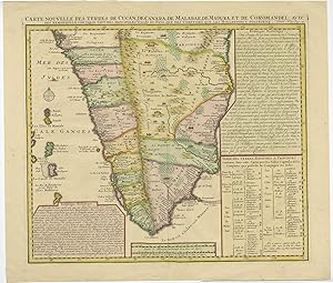
Antique Map of Southern India by H. Chatelain (1719)
H. Chatelain
Verkäufer Bartele Gallery - The Netherlands, Langweer, FRL, Niederlande
Verkäuferbewertung 5 von 5 Sternen
AbeBooks-Verkäufer seit 8. Januar 2018
Verkäufer Bartele Gallery - The Netherlands, Langweer, FRL, Niederlande
Verkäuferbewertung 5 von 5 Sternen
AbeBooks-Verkäufer seit 8. Januar 2018
Beschreibung
Antique map titled 'Carte Nouvelle des Terres de Cucan, de Canara, de Malabar, de Madura, et de Coromandel (.)'. This is an authentic antique map of the southern portion of India by Henri Chatelain. The map was published out of Amsterdam circa 1719 as part of Chatelain s seven volume Atlas Historique. This map shows from Goa and Nelour to the southern tip of India in exceptional detail. The Western Ghats mountain range runs the length of the coast while hills, forests and indigenous animals are engraved throughout. Cities, villages, ports, and bays are noted along the coast while the interior includes focuses on larger cities and regional divisions. Two text boxes present the history of the area and a table presents a breakdown of the various kingdoms, capitals, and cities within each province. Minor age-related toning, small tear along center fold. Please study image carefully. Overall size: 49.5 x 43 cm. Image size: 43 x 37.5 cm. Bestandsnummer des Verkäufers JAK-171
Bibliografische Details
Titel: Antique Map of Southern India by H. ...
Verlag: H. Chatelain
Erscheinungsdatum: 1719
Einband: No Binding
Zustand: Very Good
Anbieterinformationen
We guarantee the condition of every item as it's described on the Abebooks websites. Returns can be initiated within 14 days of delivery, please use the Ask bookseller a question link to contact us and we'll respond within 2 business days.
All orders are processed within 1-3 business days. Shipping charges for your order will be calculated and displayed at checkout.
Zahlungsarten
akzeptiert von diesem Verkäufer