
Antique Map - World on Mercator's Projection
TALLIS, John
Verlag: London: John Tallis & Company, 1851
Gebraucht
No Binding
Verk�ufer
Picture This Gallery (ABA, ILAB, PBFA), Sunningdale, Vereinigtes K�nigreich
Verk�uferbewertung 5 von 5 Sternen
![]()
AbeBooks-Verk�ufer seit 16. Oktober 2016
Dieses Exemplar ist nicht mehr verf�gbar. Hier sind die �hnlichsten Treffer f�r Antique Map - World on Mercator's Projection von TALLIS, John.
Beschreibung
Beschreibung:
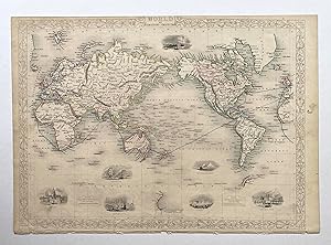
Decorative steel engraved map of the World on Mercator's Projection, surrounded by steel engraved vignette illustrations. Further enhanced with a decorative border design and the map shows the steam route around the world and to the colonies in blue. Folio, no centrefold. Original outline hand colouring. In Good+ condition, borders trimmed narrow at top and bottom and a small chip in the bottom margin among the publisher's details. Size: 26.5cm x 37.5cm. Bestandsnummer des Verk�ufers PTL-M1833
Bibliografische Details
Titel: Antique Map - World on Mercator's Projection
Verlag: London: John Tallis & Company
Erscheinungsdatum: 1851
Einband: No Binding
Zustand: Good
Auflage: 1st Edition
Beste Suchergebnisse bei AbeBooks

Foto des Verk�ufers
The World on Mercator's Projection, antique map with vignette views
Verlag:
John Tallis & Co., London, 1854
Gebraucht
Anbieter: Antipodean Books, Maps & Prints, ABAA, Garrison, NY, USA
Verk�uferbewertung 5 von 5 Sternen
![]()
Maps. Steel engraved map from the famous Victorian publisher John Tallis, well-known for the attractive vignette views surrounding the maps, which illustrate the peoples & customs of that region. Attractive decorative border around edge, vignette views of Vesuvius, London, Gibraltar, Constantinople, The Pyramids of Gizeh, Niagara and Pont Neuf, Paris & the British Colonie's colored in red, with the "Steam Route to the Colonies" colored in blue. Australia is at the center, colored in red, with Antarctic (South Victoria) designated. Three sightings of Antarctica are included: the Palmer Peninsula, South Victoria and Enderby Land, from the Ross Expedition. Period outline color, a little close on the left page margin, original center fold, very good condition overall. 10 x 13 1/2" plus margins. Bestandsnummer des Verk�ufers 19788
Gebraucht kaufen
EUR 360,85
EUR 7,63 Versand
Versand innerhalb von USA
Versand innerhalb von USA
Anzahl: 2 verf�gbar