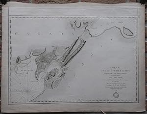
Antique Print-SEA CHART-CANADA-ISHTMUS OF CHIGNECTO-NOVA SCOTIA-Sartine-1779
Verkäufer ThePrintsCollector, Zeeland, Niederlande
Verkäuferbewertung 5 von 5 Sternen
AbeBooks-Verkäufer seit 3. April 2017
Verkäufer ThePrintsCollector, Zeeland, Niederlande
Verkäuferbewertung 5 von 5 Sternen
AbeBooks-Verkäufer seit 3. April 2017
Beschreibung
Antique print, titled: 'Plan de l'Isthme de l'Acadie compenant le Beau-Bassin avec une Partie de la Baie Verte.' - A decorative map/chart of the Ishtmus of Chignecto, on the border of New Brunswick and Nova Scotia, in the Southeast of Canada. A scarse map as we do not see it offered anywhere. Description: Published by Antoine de Sartine, comte d'Alby (1729-1801), based on a manuscript map from the "Depot General de la Marine", 1779. Ref: Phillips, Atlases 1211, no. [15].Artists and Engravers: Made by 'Petit' after an anonymous artist. Engraving on hand laid paper. Anonymous. Very good, given age. The margins browned and with some stains. Some small stains and soiling in the image. A strip of contemporary paper is attached to the rear of the top margin (possibly for binding purposes). General age-related toning and/or occasional minor defects from handling. Please study scan carefully. The overall size is ca. 36 x 25.5 cm. The image size is ca. 24.5 x 22 cm. The overall size is ca. 14.2 x 10 inch. The image size is ca. 9.6 x 8.7 inch. Storage location: Overasselt-277. Bestandsnummer des Verkäufers 63707
Bibliografische Details
Titel: Antique Print-SEA CHART-CANADA-ISHTMUS OF ...
Erscheinungsdatum: 1779
Zustand: Very Good
Anbieterinformationen
Zahlungsarten
akzeptiert von diesem Verkäufer