
Britton & Rey's Map of the State of California
GODDARD, George
Verlag: Lithographed by Britton & Rey, San Francisco, 1860
Gebraucht
Verk�ufer
Donald A. Heald Rare Books (ABAA), New York, NY, USA
Verk�uferbewertung 4 von 5 Sternen
![]()
AbeBooks-Verk�ufer seit 9. Mai 1998
Dieses Exemplar ist nicht mehr verf�gbar. Hier sind die �hnlichsten Treffer f�r Britton & Rey's Map of the State of California von GODDARD, George.
Beschreibung
Beschreibung:
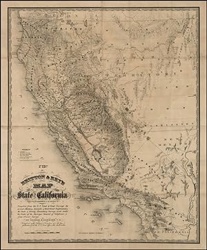
Lithographed map. Linen-backed. Extremely rare map of California. George H. Goddard came to California in 1850. In 1855, he surveyed a part of the boundary between California and Utah Territory (now Nevada). He later surveyed for the Western Pacific Railroad and for John Charles Fremont. He also surveyed most of the important passes Sierra Nevada Mountains. Mount Goddard still bears the name of this important early surveyor. In 1855, Goddard compiled a manuscript map of California on a scale of two miles to the inch. The map was a remarkable improvement on the best available maps, so much so that Marlette, the State Surveyor General petitioned the California legislature to purchase Goddard's map, stating that nowhere else could so complete and extensive a map be obtained. After the legislature rejected the proposal, Goddard submitted a version of the manuscript to Britton & Rey, who lithographed and published it for the first time in 1857. Among its many distinctions, it was the first map to accurately locate Lake Tahoe (here Lake Bigler), derived from Goddard's own surveys in the Sierra Nevada. The map shows towns and settlements, trails, wagon roads, and county boundaries. Relief is indicated by hachures; numerous spot elevations are given; and physical features are named. The scale is 1 inch to 24 miles. Coverage includes the western half of Utah Territory and a northwestern corner of New Mexico Territory--- the area comprising the future State of Nevada. The wealth of information which now appears throughout California in the present 1860 edition (stated on the map as the third edition) graphically discloses the extent to which large portions of this vast and hitherto empty land had been peopled. Gold had swiftly done its work. The Goddard map is a fitting monument to the frenzied activity and achievements of the gold seekers, and with it the purely Gold Rush phase of California cartography comes to an end. No example of either the 1858 second edition or the 1860 third edition have apparently been offered on the market in the past half century; only the Thomas W. Streeter copy of the 1857 first edition has appeared on the market in that time period. An exceptionally rare and important California map. Gold Region, 302; Wheat, Transmississippi, 921; Heckrotte, California 49, 36; Streeter Sale, 2819; Phillips, America, p. 185. Bestandsnummer des Verk�ufers 24045
Bibliografische Details
Titel: Britton & Rey's Map of the State of ...
Verlag: Lithographed by Britton & Rey, San Francisco
Erscheinungsdatum: 1860
Auflage: 1. Auflage
Beste Suchergebnisse bei AbeBooks

Foto des Verk�ufers
Britton & Rey's Map of the State of California.
Verlag:
San Francisco: Britton & Rey, 1857., 1857
Gebraucht
Erstausgabe
Anbieter: Arader Galleries - AraderNYC, New York, NY, USA
Verk�uferbewertung 5 von 5 Sternen
![]()
"Single sheet, (31 x 25 � inches). Fine folding lithographed map with original hand color in full (repaired tear, some browning and spotting). Original brown cloth with printed paper label (a bit rubbed). Provenance: From the important cartographical library of Warren Heckrotte, his sale, Rare Cartography, Exploration and Voyages, Part II, December 3, 2015, Lot 153. From the distinguished library of Thomas W. Streeter, his bookplate to the front pastedown. With the label of J.J. LeCount Bookbinder San Francisco on front pastedown. "BY FAR THE MOST COMPLETE AND ACCURATE MAP OF CALIFORNIA" (Wheat) First edition. Important map of California in first edition, with very distinguished provenance. Noted in California 49 as "the first reasonably accurate and complete map of the state. Towns, great and small, county boundaries, stage and wagon roads, including a few that traverse the Sierra Nevada, and California's first railroad from Sacramento to Folsom appear. None of the errors found on Eddy's map are present. Lake Tahoe. is shown at its correct location." Warren Heckrotte notes that "This is the Streeter-Grabhorn copy and the copy that Wheat says he used for making his description in Maps of the California Gold Region. The map is rare." "In 1857 the state of knowledge of Sierra Nevada geography was outlined in the most detailed map of California to date, a map prepared by civil engineer, surveyor, architect, and artist George H. Goddard. Goddard was born in Bristol, England, and was educated at Oxford. He, like many others, was drawn to California by the prospect of making his fortune in the gold rush. In 1850, at the age of 33, he sailed to California by way of Cape Horn. The journey from Plymouth to San Francisco, with an eight-day stopover in the Falkland Islands before rounding the Horn, took 180 days. His wife and two children remained in Europe until 1858, when the family was finally reunited. Within a year after their arrival in California a third child was born. "Goddard went to the goldfields and became a partner in a drugstore in Columbia, but by 1853 he had begun a career as a surveyor. He also maintained a professional interest in architecture, and began a serious interest in landscape painting. His first expedition was a survey of a possible railroad route over the Sierra at Sonora Pass, a route already traversed by a wagon road. The work led Goddard to other mapping excursions around the state. All the while he took copious notes and measurements that would help him later in compiling the California map. "In 1855, working for the California Surveyor General, he made a reconnaissance survey of the route over Carson Pass, and also surveyed the boundary between California and Utah Territory (in what is now western Nevada). For this work Goddard carried altitude and azimuth transits and chronometers, so that he could accurately determine by astronomical observations the latitude and longitude of important survey stations. When location and circumstance permitted, he checked the chronometers against time signals received on newly erected telegraph lines "The Goddard map of the state of California, published in 1857 by order of the Surveyor General of California [as here], is based partly on the Fremont map of 1848, though many details have been added and other improvements have been made. The map (Goddard, 1857) shows no trails crossing the Sierra in the 200-mile span of the range crest from Sonora Pass, north of Yosemite, to Walker Pass, 50 miles south of Owens Lake. No habitation is shown in Owens Valley. The U.S. Army's Fort Independence is not shown; it was established five years later, on July 4, 1862, as a result of skirmishes between settlers and Indians. The main settlement in the Central Valley of California adjacent to the parks area was Visalia (spelled 'Visaija' on the map). Fresno, Bakersfield, and Merced had not yet been settled. The map shows Tulare Lake to be about 40 miles long, whereas on the Fremont m". Bestandsnummer des Verk�ufers 72MMS375
Anzahl: 1 verf�gbar