
Carte generale des decouvertes de l Amiral de Fonte
Vaugondy,de Robert ( 1723 - 1786 ) Paris
Verlag: Artist: Vaugondyde Robert ( - 1786 ) Paris issued in: Paris; - Didier Robert de Vaugondy (1723 -1786) also known as Le Sieur or Monsieur Robert and his son were leading cartographers in France during the 18th century In 1757 Gilles and Didier Robert De Vaugondy published The Atlas Universel one of the most important atlases of the 18th century To produce the atlas the Vaugondys integrated older sources with more modern surveyed maps They verified and corrected the latitude and longitude of many regional maps in the atlas with astronomical observations The older material was revised with the addition of many new place names In 1760 Didier Robert de Vaugondy was appointed geographer to Louis XV Gilles and Didier Robert De Vaugondy produced th, 1723
Gebraucht
Verk�ufer
Antique Sommer& Sapunaru KG, M�nchen, Deutschland
Verk�uferbewertung 2 von 5 Sternen
![]()
AbeBooks-Verk�ufer seit 13. Mai 2015
Dieses Exemplar ist nicht mehr verf�gbar. Hier sind die �hnlichsten Treffer f�r Carte generale des decouvertes de l Amiral de Fonte von Vaugondy,de Robert ( 1723 - 1786 ) Paris.
Beschreibung
Beschreibung:
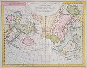
Technic: Copper print, colorit: colored, condition: Perfect condition, size (in cm): 29,5 x 38 cm cm; - Map shows the north Pacific with Sibiria, North America and a inset map with the Archipel St. Lazare in Canada. Bestandsnummer des Verk�ufers SE235_500
Bibliografische Details
Titel: Carte generale des decouvertes de l Amiral ...
Verlag: Artist: Vaugondyde Robert ( - 1786 ) Paris issued in: Paris; - Didier Robert de Vaugondy (1723 -1786) also known as Le Sieur or Monsieur Robert and his son were leading cartographers in France during the 18th century In 1757 Gilles and Didier Robert De Vaugondy published The Atlas Universel one of the most important atlases of the 18th century To produce the atlas the Vaugondys integrated older sources with more modern surveyed maps They verified and corrected the latitude and longitude of many regional maps in the atlas with astronomical observations The older material was revised with the addition of many new place names In 1760 Didier Robert de Vaugondy was appointed geographer to Louis XV Gilles and Didier Robert De Vaugondy produced th
Erscheinungsdatum: 1723
Beste Suchergebnisse bei AbeBooks

Foto des Verk�ufers
Carte generale des decouvertes de l amiral de Fonte.
Anbieter: Antique Sommer& Sapunaru KG, M�nchen, Deutschland
Verk�uferbewertung 2 von 5 Sternen
![]()
Technic: Copper print, colorit: coloredcondition: Very good, size (in cm): 29 x 35 cm; - Map shows Alasca and the Beringstreet. Bestandsnummer des Verk�ufers SE236
Anzahl: 1 verf�gbar
Foto des Verk�ufers
Carte generale des decouvertes de l Amiral de Fonte
Anbieter: Antique Sommer& Sapunaru KG, M�nchen, Deutschland
Verk�uferbewertung 2 von 5 Sternen
![]()
Technic: Copper print, colorit: coloredcondition: Upper margin some restoration, size (in cm): 29 x 37 cm cm; - Map shows the north Pacific with Sibiria, North America and a inset map with the Archipel St. Lazare in Canada. Bestandsnummer des Verk�ufers AMU1251
Anzahl: 1 verf�gbar
Foto des Verk�ufers
Carte generale des decouvertes de l Amiral de Fonte
Anbieter: Antique Sommer& Sapunaru KG, M�nchen, Deutschland
Verk�uferbewertung 2 von 5 Sternen
![]()
Technic: Copper print, colorit: coloredcondition: Perfect condition, size (in cm): 29,5 x 38 cm cm; - Map shows the north Pacific with Sibiria, North America and a inset map with the Archipel St. Lazare in Canada. Bestandsnummer des Verk�ufers SE235
Anzahl: 1 verf�gbar