
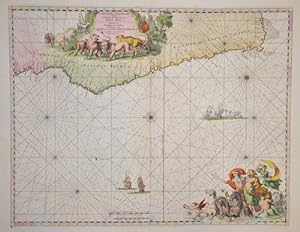
Cimbebas et Caffariae Littora a Catembela ad Promontorium Boan Spei.
Wit, de Frederick ( 1610 - 1698 ) Amsterdam
Verlag: Artist: Wit de Frederick ( - 1698 ) Amsterdam issued in: Amsterdam; - Frederik de Wit (1610 ? 1698) His Atlas began to appear around 1662 and by 1671 included anywhere from 17 to 151 maps each In the 1690s he began to use a new title page "Atlas Maior" but continued to use his old title page His atlas of the Low Countries first published in 1667was named Nieuw Kaertboeck van de XVII Nederlandse Provinciën and contained 14 to 25 maps Frederik de Wit quickly expanded upon his first small folio atlas which contained mostly maps printed from plates that he had acquired to an atlas with 27 maps engraved by or for him By 1671 he was publishing a large folio atlas with as many as 100 maps Smaller atlases of 17 or 27 or 51 maps could still be purch, 1610
Gebraucht
Verk�ufer
Antique Sommer& Sapunaru KG, M�nchen, Deutschland
Verk�uferbewertung 2 von 5 Sternen
![]()
AbeBooks-Verk�ufer seit 13. Mai 2015
Dieses Exemplar ist nicht mehr verf�gbar. Hier sind die �hnlichsten Treffer f�r Cimbebas et Caffariae Littora a Catembela ad Promontorium Boan Spei. von Wit, de Frederick ( 1610 - 1698 ) Amsterdam.
Beschreibung
Beschreibung:
Technic: Copper print, colorit: original colored, condition: Very good, size (in cm): 42,5 x 55 cm; - Map shows the Atlatic with the western coast of Africa. Bestandsnummer des Verk�ufers SE0290_500
Bibliografische Details
Titel: Cimbebas et Caffariae Littora a Catembela ad...
Verlag: Artist: Wit de Frederick ( - 1698 ) Amsterdam issued in: Amsterdam; - Frederik de Wit (1610 ? 1698) His Atlas began to appear around 1662 and by 1671 included anywhere from 17 to 151 maps each In the 1690s he began to use a new title page "Atlas Maior" but continued to use his old title page His atlas of the Low Countries first published in 1667was named Nieuw Kaertboeck van de XVII Nederlandse Provinci�n and contained 14 to 25 maps Frederik de Wit quickly expanded upon his first small folio atlas which contained mostly maps printed from plates that he had acquired to an atlas with 27 maps engraved by or for him By 1671 he was publishing a large folio atlas with as many as 100 maps Smaller atlases of 17 or 27 or 51 maps could still be purch
Erscheinungsdatum: 1610
Beste Suchergebnisse bei AbeBooks

Foto des Verk�ufers
Cimbebas et Caffariae Littora a Catembela ad Promontorium Boan Spei.
Anbieter: Antique Sommer& Sapunaru KG, M�nchen, Deutschland
Verk�uferbewertung 2 von 5 Sternen
![]()
Technic: Copper print, colorit: original coloredcondition: Very good, size (in cm): 42,5 x 55 cm; - Map shows the Atlatic with the western coast of Africa. Bestandsnummer des Verk�ufers SE0290
Anzahl: 1 verf�gbar