


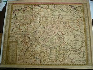
Germany/Europe, generalmap by Chatelain Henri, anno 1732, old colours Nouvelle Carte De L'Allemagne avec des Tables des. Nouvelle Carte De L'Allemagne avec des Tables des Branches de la Noblesse et les Lieux Les Plus Remarquables de Leurs Residance Paris / 1732 Size of the sheet: 51 x 64 cm., old colours, little brownish. Detailed map of the German Empire, from Chatelain's monumental 7 volume Atlas Historique, published by Chatelain in Amsterdam The map is flanked by two tables identifying the principal towns and regions associated with each of the different dynasties.
Chatelain
Erscheinungsdatum: 1732
Karte
Zustand: Befriedigend
Verk�ufer Hammelburger Antiquariat, Hammelburg, Deutschland
Verk�uferbewertung 4 von 5 Sternen
![]()
AbeBooks-Verk�ufer seit 22. September 2015