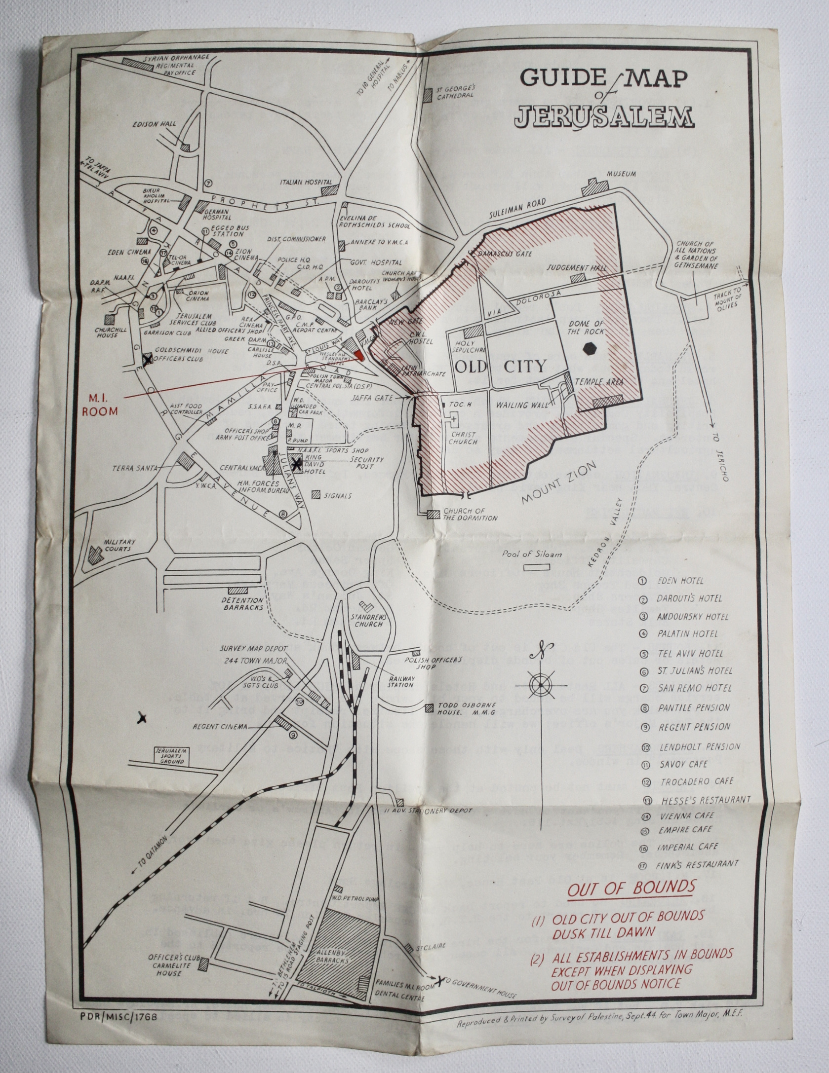
Returns accepted within 30 days of the estimated delivery date. Please contact me
first with the reason. Buyer pays the cost of postage in both directions unless
the item is not as described. Name: Nils Bhinda. Address: Flat 9, 7 Copers Cope
Road, Beckenham BR3 1NE, Kent, ENGLAND. E-mail: nils_bhinda@yahoo.co.uk. Tel: +44-
(0)794-141-2119.
Wenn Sie Verbraucher sind, steht Ihnen ein Widerrufsrecht nach folgender Ma�gabe zu. Verbraucher ist jede nat�rliche Person, die ein Rechtsgesch�ft zu Zwecken abschlie�t, die �berwiegend weder ihrer gewerblichen noch ihrer selbst�ndigen beruflichen T�tigkeit zugerechnet werden k�nnen.
WIDERRUFSBELEHRUNG
Widerrufsrecht
Sie haben das Recht, binnen vierzehn Tagen ohne Angabe von Gr�nden diesen Vertrag zu widerrufen.
Die Widerrufsfrist betr�gt vierzehn Tage ab dem Tag, an dem Sie oder ein von Ihnen benannter Dritter, der nicht der Bef�rderer ist, die letzte Ware oder die letzte Teilsendung bzw. das letzte St�ck in Besitz genommen haben bzw. hat.
Um Ihr Widerrufsrecht auszu�ben, m�ssen Sie uns, Dendera, Flat 9 Sycamore Court, 7 Copers Cope Road, BR3 1NE, Beckenham, United Kingdom, +44 2086630918, mittels einer eindeutigen Erkl�rung (z.B. ein mit der Post versandter Brief, Telefax oder E-Mail) �ber Ihren Entschluss, diesen Vertrag zu widerrufen, informieren. Sie k�nnen daf�r das beigef�gte Muster-Widerrufsformular verwenden, das jedoch nicht vorgeschrieben ist. Sie k�nnen auch eine andere eindeutige Erkl�rung auf der Webseite "Meine Bestellungen" in Ihrem "Nutzerkonto" elektronisch ausf�llen und �bermitteln. Machen Sie von dieser M�glichkeit Gebrauch, so werden wir Ihnen unverz�glich (z. B. per E-Mail) eine Best�tigung �ber den Eingang eines solchen Widerrufs �bermitteln. Zur Wahrung der Widerrufsfrist reicht es aus, dass Sie die Mitteilung �ber die Aus�bung des Widerrufsrechts vor Ablauf der Widerrufsfrist absenden.
Folgen des Widerrufs
Wenn Sie diesen Vertrag widerrufen, haben wir Ihnen alle Zahlungen, die wir von Ihnen erhalten haben, einschlie�lich der Lieferkosten (mit Ausnahme der zus�tzlichen Kosten, die sich daraus ergeben, dass Sie eine andere Art der Lieferung als die von uns angebotene, g�nstigste Standardlieferung gew�hlt haben), unverz�glich und sp�testens binnen vierzehn Tagen ab dem Tag zur�ckzuzahlen, an dem die Mitteilung �ber Ihren Widerruf dieses Vertrags bei uns eingegangen ist. F�r diese R�ckzahlung verwenden wir dasselbe Zahlungsmittel, das Sie bei der urspr�nglichen Transaktion eingesetzt haben, es sei denn, mit Ihnen wurde ausdr�cklich etwas anderes vereinbart; in keinem Fall werden Ihnen wegen dieser R�ckzahlung Entgelte berechnet. Wir k�nnen die R�ckzahlung verweigern, bis wir die Waren wieder zur�ckerhalten haben oder bis Sie den Nachweis erbracht haben, dass Sie die Waren zur�ckgesandt haben, je nachdem, welches der fr�here Zeitpunkt ist. Sie haben die Waren unverz�glich und in jedem Fall sp�testens binnen vierzehn Tagen ab dem Tag, an dem Sie uns �ber den Widerruf dieses Vertrags unterrichten, an Dendera, Flat 9 Sycamore Court, 7 Copers Cope Road, BR3 1NE, Beckenham, United Kingdom, +44 2086630918, zur�ckzusenden oder zu �bergeben. Die Frist ist gewahrt, wenn Sie die Waren vor Ablauf der Frist von vierzehn Tagen absenden.
Sie tragen die unmittelbaren Kosten der R�cksendung der Waren. Sie m�ssen f�r einen etwaigen Wertverlust der Waren nur aufkommen, wenn dieser Wertverlust auf einen zur Pr�fung der Beschaffenheit, Eigenschaften und Funktionsweise der Waren nicht notwendigen Umgang mit ihnen zur�ckzuf�hren ist.
Ausnahmen vom Widerrufsrecht
Das Widerrufsrecht besteht nicht bzw. erlischt bei folgenden Vertr�gen:
- Zur Lieferung von Zeitungen und Zeitschriften oder Illustrierten, mit Ausnahme von Abonnement Vertr�gen;
- Bei der Lieferung digitaler Inhalte, die nicht auf einem k�rperlichen Datentr�ger (z.B. einer CD oder DVD) geliefert werden, wenn Sie dem Beginn der Ausf�hrung vor der Bestellung ausdr�cklich zugestimmt und zur selben Zeit best�tigt haben, dass mit der Ausf�hrung begonnen werden kann und Sie Ihr Widerrufsrecht verlieren, sobald die Ausf�hrung begonnen hat.
ENDE DER WIDERRUFSBELEHRUNG
Muster-Widerrufsformular
(Wenn Sie den Vertrag widerrufen wollen, dann f�llen Sie bitte dieses Formular aus und senden Sie es zur�ck)
An: (Dendera, Flat 9 Sycamore Court, 7 Copers Cope Road, BR3 1NE, Beckenham, United Kingdom, +44 2086630918)
Hiermit widerrufe(n) ich/wir* den von mir/uns* abgeschlossenen Vertrag �ber den Kauf der folgenden Waren*/ die Erbringung der folgenden Dienstleistung*
Bestellt am*/erhalten am*:
Name des/der Verbraucher(s):
Anschrift des/der Verbraucher(s):
Unterschrift des/der Verbraucher(s) (nur bei Mitteilung auf Papier):
Datum:
* Unzutreffendes streichen.
