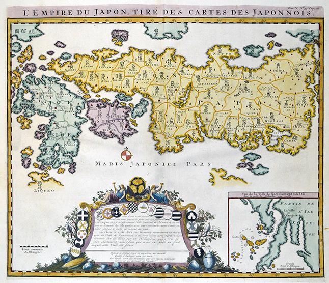
L'Empire du Japon, Tire des Cartes des Japonnois.
Henry Abraham Chatelain.
Erscheinungsdatum: 1719
Gebraucht
No Binding
Verk�ufer
The Isseido Booksellers, ABAJ, ILAB, Tokyo, Japan
Verk�uferbewertung 3 von 5 Sternen
![]()
AbeBooks-Verk�ufer seit 4. Juni 2013
Verbandsmitglied:
Dieses Exemplar ist nicht mehr verf�gbar. Hier sind die �hnlichsten Treffer f�r L'Empire du Japon, Tire des Cartes des Japonnois..
Beschreibung
Beschreibung:
36 x 43.5cm. Original engraved map, hand colored, slightly worn. Bestandsnummer des Verk�ufers Y20010007
Bibliografische Details
Titel: L'Empire du Japon, Tire des Cartes des ...
Erscheinungsdatum: 1719
Einband: No Binding
Zustand: Good
Zustand des Schutzumschlags: No Jacket
Beste Suchergebnisse bei AbeBooks

Foto des Verk�ufers
(Map) L'empire du Japon tir� des cartes des japonnois
Gebraucht
Softcover
Anbieter: Libreria Anticuaria Camino de Santiago, Le�n - Madrid, Spanien
Verk�uferbewertung 5 von 5 Sternen
![]()
Zustand: Bueno. 30074 Chatelain 1719 Atlas historique ou nouvelle introduction a l'histoire, � la chronologie & � la geographie ancienne & moderne, Chatelain, 1719. 56x43 cms. SOLICITEN FOTOGRAF�A Jap�n,Japanese Maps,Japan Soliciten fotos o m�s informaci�n. Bestandsnummer des Verk�ufers 30074
Anzahl: 1 verf�gbar
Foto des Verk�ufers
L'Empire du Japon, Tire des Cartes des Japonnois.
Verlag:
Giappone
Gebraucht
Anbieter: Sergio Trippini, Gavirate, Italien
Verk�uferbewertung 5 von 5 Sternen
![]()
Carta geografica, antica ed originale, del Giappone, con mappa inserita: "Vue de la Ville de Nangasacki & de L'Ile. dans la quelle les Hollandois son �tablis. Questa mappa � basata sulla mappa di Adrian Reland del 1715 e una delle prime ad utilizzare sia nomi latini che caratteri giapponesi. Cartiglio di dedica ornato, con stemmi, rosa dei venti e testo. Rilievo raffigurato. Inserita nel V Tomo "Atlas Historique ou nouvelle introduction a l'Histoire, � la Chronologie & � la Geographie Ancienne & Moderne?", pubblicato ad Amsterdam nel 1719. Atlante che, con la sua pubblicazione, coniuga le mappe geografiche con incisioni e informazioni di carattere geografico, araldico, etnografico e storico cos� rendendo l'opera in sette volumi molto innovativa.Henri Abraham Chatelain (1684 - 1743), pastore ugonotto originario di Parigi visse alternativamente a Parigi, Londra, L'Aia ed Amsterdam. Conosciuto come cartografo olandese per il sua opera cartografica monumentale in sette volumi "Atlas Historique" pubblicata ad Amsterdam con i suoi fratelli. Bestandsnummer des Verk�ufers ST56052
Anzahl: 1 verf�gbar
L'Empire du Japon, Tire des Cartes des Japonnois", Chatelain, Henry Abraham Subject: Japan Period: 1719 Publication: Atlas Historique Size of the sheet: 47x56 cm., good condition, no cracs or tears, only little brownish. This bold map of Japan is based on Adrian Reland's map of 1715. Reland's map was based on a Japanese model that had been produced as a travel map. As such, the geographical shape of the islands was made to fit into a predetermined format. This distorted shape resulted in a truncated Honshu, thus actually setting the European cartography of Japan backwards for a short period of time. On the other hand, the superb depiction of Kyushu is not surpassed until the 19th century. Reland's map is also important for its use of Sino
Gebraucht
Anbieter: Hammelburger Antiquariat, Hammelburg, Deutschland
Verk�uferbewertung 4 von 5 Sternen
![]()
Kein Einband. Zustand: Gut. L'Empire du Japon, Tire des Cartes des Japonnois", Chatelain, Henry Abraham Subject: Japan Period: 1719 Publication: Atlas Historique Size of the sheet: 47x56 cm., good condition, no cracs or tears, only little brownish. This bold map of Japan is based on Adrian Reland's map of 1715. Reland's map was based on a Japanese model that had been produced as a travel map. As such, the geographical shape of the islands was made to fit into a predetermined format. This distorted shape resulted in a truncated Honshu, thus actually setting the European cartography of Japan backwards for a short period of time. On the other hand, the superb depiction of Kyushu is not surpassed until the 19th century. Reland's map is also important for its use of Sino-Japanese characters (in addition to Dutch) for all sixty-six provinces. Chatelain's version includes several errors in the Dutch names, which were likely not noticed by his French clientele. An inset map of Nagasaki shows the Dejima, an artificial island in Nagasaki harbor that housed the Dutch trading station of the VOC. Bestandsnummer des Verk�ufers ABE-1557653525123
Anzahl: 1 verf�gbar
Foto des Verk�ufers
L'Empire du Japon, Tir� des Cartes des Japonnois.
Gebraucht
Anbieter: Altea Antique Maps, London, Vereinigtes K�nigreich
Verk�uferbewertung 5 von 5 Sternen
![]()
Amsterdam, 1719. 380 x 440mm. A fine, dark impression. A map of Japan based on Reland's landmark map of 1715, with Japanese script naming the sixty-six provinces. Under the map is a large cartouche with the shields of the noble families of Japan and a text describing the Japanese sources for his map (although not mentioning Reland). To the right is an inset chart of Nagasaki Harbour. The map was published in the 'Atlas Historique' a seven-volume atlas that is usually attributed to Henri Abraham Ch�telain; however Hubbard and other recent writers posit that it was his brother Zacherie who compiled the work. HUBBARD: 73. Bestandsnummer des Verk�ufers 17371
Anzahl: 1 verf�gbar