Beschreibung
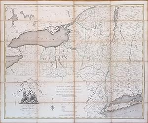
THE THOMAS BEE COPY. First "Contracted" edition. Engraved folding map (27 3/4" x 28 5/8", 602mm x 727mm), hand-colored in outline, laid down on linen and dissected into 24 sections. In the publisher's card slip-case in colored floral paper, with the publisher's printed paper label ("DE WITT's MAP/ of the/ STATE of NEW-YORK") to the front. Tanned at the folds, with some exterior soiling. Linen fraying at the peripheries. Ink ownership signature of "T. BEE/ 1808" to the verso of the top-right section, and folding instruction ("Outside") to the verso of the bottom-right section. The slip-case tender, with splits and some losses, including to the paper label. Ink ownership inscription of "Thomas Bee. 1808" to the paper label, and an old bookseller's notation in graphite. Simeon de Witt (1756-1834) was one of America's great early surveyors. He was Geographer and Surveyor of the Continental Army from 1780, and held the office of Surveyor General of the State of New York for 50 years -- from 1784 till his death. In that capacity, he was one of four commisioners whose 1811 gridding of Manhattan (the Commissioners' Plan) established the makeup of modern New York. The larger part of his work -- putting aside a New Yorker's chauvinism -- was mapping the western part of the state, and in particular firming up the border with Pennsylvania. From 1786, de Witt was charged by the state legislature with surveying and creating a map of New York (with parts of Pennsylvania, New Jersey, Connecticut, Massachusetts, Vermont and New Hampshire), which he produced in 1802. That vast map, more than 5' tall (at a scale of 316,800:1), showed the western portion of the state at a reduced scale. It was perhaps natural, therefore, that the present map -- "contracted" -- should be produced, the first properly-surveyed map to show the whole state at a consistent scale (950,400:1). Thomas Bee (1739-1812) was a South Carolina Patriot, and one of their delegation to the Second Continental Congress. Educated at Oxford (Oriel College) in law, he practiced law in Charleston before serving in the various iterations of the state assembly, rising to be lieutenant-governor in 1780. In 1790 he was nominated by George Washington to the federal bench, and served until his death. Ristow, pp. 73-83; Rumsey 2489; Streeter 893. Bestandsnummer des Verkäufers JLR0587
Verkäufer kontaktieren
Diesen Artikel melden
![]()


