Beschreibung
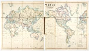
Cruchley s 1855 map of the world in original boards and marbled backing an attractive addition to any world map collection.// This stunning world map is highly characteristic for the age in which it was produced; that is, a time when humanity especially the colonial powers of Europe thought themselves pretty savvy when it came to understanding the world s geography. European explorers, merchants, and war ships had after all been plowing the high seas for centuries at this stage. Nevertheless, the map is also testament to a global political structure and hierarchy that was doomed to fail. In this light, the map is full of oddities and curiosities, but also full of errors, assumptions, and very short-lived constructions. Let us dive into a few of them here. The map consists of two sheets, with each sheet having been dissected and backed on linen so that it measures approximately 33 x 37 inches (c. 84 x 94 cm). While clearly two parts of a single whole, each sheet depicts a set of landmasses; Eurasia, Africa and Australia on the right and the Americas on the left. When joined, this provides a perspective in which the Pacific Ocean constitutes the centre of the image. One of the most interesting aspects of the map for an American audience is certainly the labeling of Alaska as Russian America. This was of course the common term for Russia s colonial possessions in North America. While Russians had maintained a presence in America since the mid 18th century, it was not until Paul I issued the decree (or Ukasse) of 1799 that these settlements were formalized as Russian territory. While the majority of the Russian presence was in Alaska, with their capital at Novo-Arkhangelsk (modern Sitka), there were also small Russian colonies in California and three Russian forts on Hawaii (here still labeled the Sandwich Islands ). Initially, the Russian settlements in Alaska prospered especially as a result of the fur trade. But excessive hunting, unreliable transport infrastructure, and domestic problems back in Mother Russia, lead to a slow decline over the course of the 19th century. By 1860, five years after this map was published, most Russian settlements in Alaska had been abandoned, and only seven years later, in 1867, the Russian territory was formally sold to the United States for just over seven million dollars. Neatline is famous for its detailed and in-depth descriptions. To receive the full description for this listing free of charge, please contact us using the 'ask the seller' function below. Bestandsnummer des Verk�ufers NL-01217
Verk�ufer kontaktieren
Diesen Artikel melden
