


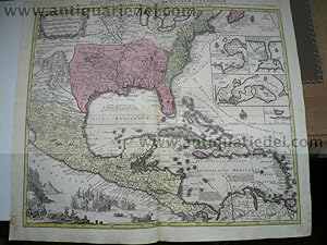
Mappa Geographica Regionem Mexicanam et Floridam. Terrasque adjacentes, ut et Anteriores Americae Insulas, Cursius itidem et Reditus Navigantium versus flumen Missispi et alias Colonias…" Matthias Seutter This is Mathias Seutter's decorative and beautifully engraved version of Delisle's important map of 1703 (Carte du Mexique et de la Floride). It provides a view of North America from the Great Lakes through the West Indies. The British colonies are confined east of the Appalachian Mountains, France controls the Mississippi valley and Florida, and Spain possesses Mexico; political divisions as dictated by the Treaty of Utrecht in 1713. New Mexico is finely described with many native tribes and pueblos noted, including Acoma, Santa Clara, Is
Seutter Matthaeus
Verlag: Seutter/Augsburg, 1740
Karte
Zustand: Gut
Verkäufer Hammelburger Antiquariat, Hammelburg, Deutschland
Verkäuferbewertung 4 von 5 Sternen
![]()
AbeBooks-Verkäufer seit 22. September 2015
Gebraucht -
Preis:
EUR 1.400,00
Währung umrechnen
EUR 30,00
für den Versand von Deutschland nach USA
Versandziele, Kosten & Dauer
Anzahl: 1 verfügbar
In den Warenkorb legen