
Murrells Inlet to Cape Romain Including Winyah Bay
[South Carolina]
Verlag: Published by the United States Coast and Geodetic Survey, Washington D.C., 1920
Gebraucht
Verk�ufer
Donald A. Heald Rare Books (ABAA), New York, NY, USA
Verk�uferbewertung 4 von 5 Sternen
![]()
AbeBooks-Verk�ufer seit 9. Mai 1998
Dieses Buch ist nicht mehr verf�gbar. AbeBooks f�hrt Millionen von B�chern. Bitte geben Sie unten Suchbegriffe ein, um �hnliche Exemplare zu finden.
Beschreibung
Beschreibung:
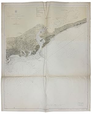
Large folding nautical chart, printed on heavy paper stock. Colored. A rare original coastal survey of South Carolina from Murrells Inlet to Cape Romain including Georgetown, Winyah Bay, Santee Coastal Reserve, Tom Yawkey Wildlife Center, DeBordieu Island, Litchfield by the Sea, and Pawleys Island. Established by President Thomas Jefferson in 1807 as the Survey of the Coast, the U.S. Coast and Geodetic Survey was the United States' first civilian scientific agency. This agency has followed its mission to survey the U.S. coastline, create nautical charts of the coast, and help increase maritime safety since its founding, and has often played fascinating roles in significant chapters of U.S. history. It served in all theaters of the Civil War in the service of the Union Army and Navy, pioneered acoustic exploration in the wake of the sinking of the Titanic, and during WWI it worked to detect enemy submarines. In addition, this agency worked to survey and produce detailed maps and renderings of the U.S. coast. These nautical survey maps (commonly referred to as "T-sheets") provide fascinating insights into the history of the United States coastline, which has and will continue to shift. These maps are the most important data source for understanding the physical and ecological characteristics of the U.S. shoreline. The present map is notable for its spelling of DeBordieu Island as Debidue. This map is a highly detailed and accurate sea chart of coastal South Carolina, and an important historical view of the developing state. Bestandsnummer des Verk�ufers 41212
Bibliografische Details
Titel: Murrells Inlet to Cape Romain Including ...
Verlag: Published by the United States Coast and Geodetic Survey, Washington D.C.
Erscheinungsdatum: 1920
AbeBooks ist ein Internet-Marktplatz f�r neue, gebrauchte, antiquarische und vergriffene B�cher. Bei uns finden Sie Tausende professioneller Buchh�ndler weltweit und Millionen B�cher. Einkaufen bei AbeBooks ist einfach und zu 100% sicher — Suchen Sie nach Ihrem Buch, erwerben Sie es �ber unsere sichere Kaufabwicklung und erhalten Sie Ihr Buch direkt vom H�ndler.
Millionen neuer und gebrauchter B�cher bei tausenden Anbietern
Neue und gebrauchte B�cher

Neue und gebrauchte Exemplare von Neuerscheinungen, Bestsellern und preisgekr�nten B�chern. Eine riesige Auswahl an g�nstigen B�chern.
Antiquarische B�cher

Von seltenen Erstausgaben bis hin zu begehrten signierten Ausgaben ? bei AbeBooks finden Sie eine gro�e Anzahl seltener, wertvoller B�cher und Sammlerst�cke.
Versandkostenfreie B�cher

Hier finden Sie viele hunderttausend neue, gebrauchte und antiquarische B�cher, die Ihnen unsere deutschen und internationalen H�ndler versandkostenfrei liefern.