Beschreibung
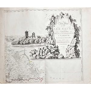
FIRST EDITION, large engraved map on six double-page sheets, outlined in colour, decorative title vignette, compass rose, dedication to the Nobility, Gentry and Subscribers for the county of Ayr, inset plan of Ayr, sheets bound separately, good margins, contemporary morocco back marbled boards, boards slightly rubbed, corners worn, folio, slight water staining to endpapers, map unaffected, 1775 A nice copy of this large map of Ayrshire, covering from the Firth of Clyde down to the border of Galloway. The highly detailed map shows villages, noted houses, churches, farmland, mountains, rivers, lakes, bogs, woods, coal pits and various types of roads. The demand for large-scale county maps increased in the eighteenth and early nineteenth century due to the radical changes being made to the landscape, a result of industrialisation, population growth and migration. Trigonometrical surveying had replayed the traverse and sketch methods used prior, leading to a higher standard in accuracy and detail. The title cartouche has a significant role, both as an ornamental feature but also as a pictorial representation of the area. Here the rolling and forest territory of Ayrshire is beautifully illustrated. The rivers, burns and ancient architecture of the area can also be seen.Ā. Bestandsnummer des Verkõufers 6190
Verkõufer kontaktieren
Diesen Artikel melden


