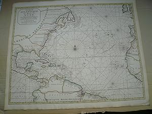
Ocean Atlantique ou Mer du Nord. Ou sont Exactement observee le Route d'Europe aux Indes Occidentales in Europe . . . . 17th Century Dutch Sea Chart of The East Coast of America and the Atlantic Trade Route, illustrating the modern European Trade Routes to the West Indies and Eastern Coast of America at the end of the 17th Century . Edited anno 1700, Mortier Pierre, coloured by an contemporary hand. Size of the sheet: 51 x 62 cm., good condition, only little brownish. Fine original color example of Pierre Mortier's large format map of the Eastern Coastline of North America, Gulf Coast, Caribbean, Central America and the northern coasts of South America, illustrating the trans-Atlantic trade route from Europe to the "Indes Occidentales" and
Mortier Pierre
Verkäufer Hammelburger Antiquariat, Hammelburg, Deutschland
Verkäuferbewertung 4 von 5 Sternen
![]()
AbeBooks-Verkäufer seit 22. September 2015


