
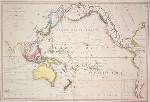
Oceanie ou Australasie et Polynésie
Lapie Alexandre Emile Paris
Verlag: Artist: Lapie Alexandre Emile Paris issued in: Paris; - Pierre M Lapie ( ? 1850) was a French cartographer and engraver He was the father of cartographer Alexandre Emile Lapie Lapie was a Colonel in the French army where he worked in the corps of topographical engineers Lapie worked closely with his son and published works together and individually The work of Lapie and his son was influential on German commercial map makers in the 19th century, 1779
Gebraucht
Verkäufer
Antique Sommer& Sapunaru KG, München, Deutschland
Verkäuferbewertung 2 von 5 Sternen
![]()
AbeBooks-Verkäufer seit 13. Mai 2015
Dieses Exemplar ist nicht mehr verfügbar. Hier sind die ähnlichsten Treffer für Oceanie ou Australasie et Polynésie.
Beschreibung
Beschreibung:
Technic: Copper print, colorit: original colored, condition: Very good, size (in cm): 49 x 73 cm; - Map of the Pacific Ocean. Bestandsnummer des Verkäufers OZ188_500
Bibliografische Details
Titel: Oceanie ou Australasie et Polynésie
Verlag: Artist: Lapie Alexandre Emile Paris issued in: Paris; - Pierre M Lapie ( ? 1850) was a French cartographer and engraver He was the father of cartographer Alexandre Emile Lapie Lapie was a Colonel in the French army where he worked in the corps of topographical engineers Lapie worked closely with his son and published works together and individually The work of Lapie and his son was influential on German commercial map makers in the 19th century
Erscheinungsdatum: 1779
Beste Suchergebnisse bei AbeBooks
Océanie. Ou Australasie, Polynésie et iles Asiatiques. Dressée par P. Lapie, Géographe.
Verlag:
Chamouin o.J. (wohl 1809)., Paris, 1809
Gebraucht
Anbieter: BerlinAntiquariat, Karl-Heinz Than, Berlin, Deutschland
Verkäuferbewertung 5 von 5 Sternen
![]()
Kupferstich. Zeichnung von dem Geographen P. Lapie. Stich bei Chamouin, Paris. Das Papier ist noch frisch. In dieser Karte ist außer der Flüsse auch das Relieff der Inseln mit eingezeichnet. Australien sowie einige weitere Inseln sind diskret mit Farbe grenzkoloriert. Auch vorhanden: ein ähnliches, weniger ausführliches und wohl etwas früheres Exemplar. Siehe hierzu Bestellnummer 31378. Dieses Exemplar befindet sich in einem zeitgemäß sehr guten Zustand. Siehe Foto. Kupferstich. 1 Blatt. Bestandsnummer des Verkäufers 31379
Anzahl: 1 verfügbar

Foto des Verkäufers
Oceanie, Ou Australasie, Polynesie et Iles Asiatiques
Gebraucht
Map
Anbieter: Roger Collicott Books, Widecombe in the Moor, DEVON, Vereinigtes Königreich
Verkäuferbewertung 5 von 5 Sternen
![]()
Map. Zustand: Near Fine. Detalied French map with delicate original outline hand colouring. Not only is Australia shown but also the Pacific Islands, Japan, and part of the Chinese mainland. No date, c1820s? Bestandsnummer des Verkäufers 000593
Anzahl: 1 verfügbar
Foto des Verkäufers
(Oceania Map) Oceanie Ou Australasie, Polynesie Et Iles Asiatiques
Gebraucht
Anbieter: Hornseys, Ripon, Vereinigtes Königreich
Verkäuferbewertung 5 von 5 Sternen
![]()
No Binding. Zustand: Near Fine. Original copper engraving. Date: 1824. Sheet size: 40.5cm x 28.2cm. Outline hand-colouring, as issued. Minor fraying which is confined to the margins. In near fine, bright, clean condition. Bestandsnummer des Verkäufers 000975
Anzahl: 1 verfügbar
Foto des Verkäufers
Océanie, ou Australasie, Polynésie et Iles Asiatiques. Dressée par P. Lapie Géographe.
Gebraucht
Anbieter: Antiquariaat Dat Narrenschip, Middelburg, Niederlande
Verkäuferbewertung 5 von 5 Sternen
![]()
No Binding. Zustand: Fine. Antique map of Australia, New Zealand, Indonesia and the small islands in the Pacific. Title cartouche bottom right. Backside blank. Hand-coloured copper engraving, published in Paris in 1816 by Magimel, Anselin et Pochard in "Atlas classique et universel de Géographie ancienne et moderne," P. Lapie. Dimensions (image): 22 x 29 cm. Bestandsnummer des Verkäufers ABE-1635265829848
Anzahl: 1 verfügbar
Foto des Verkäufers
Oceanie ou Australasie et Polynesie
Verlag:
Paris, 1816
Gebraucht
Anbieter: Alexandre Antique Prints, Maps & Books, Toronto, ON, Kanada
Verkäuferbewertung 2 von 5 Sternen
![]()
Zustand: Excellent. Size : 310x232 (mm), 12.25x9.125 (Inches), Hand Colored in outline. Bestandsnummer des Verkäufers M614
Anzahl: 1 verfügbar
Foto des Verkäufers
Oceanie ou Australasie et Polynésie
Anbieter: Antique Sommer& Sapunaru KG, München, Deutschland
Verkäuferbewertung 2 von 5 Sternen
![]()
Technic: Copper print, colorit: original coloredcondition: Very good, size (in cm): 49 x 73 cm; - Map of the Pacific Ocean. Bestandsnummer des Verkäufers OZ188
Anzahl: 1 verfügbar