
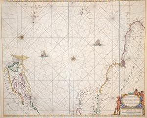
Pascaerte van de Vlaemsche, Soute, en Caribesche Eylanden.
Keulen Johannes van ( 1654 - 1715 ) Amsterdam
Verlag: Artist: Keulen Johannes van ( - 1715 ) Amsterdam issued in: Amsterdam; - Johannes van Keulen (1654 - 1715) was a 17th-century Dutch cartographer He published the influential nautical atlas the Zee-Atlas and the pilot guide Zee-Fakkel In 1678 Johannes van Keulen established himself in Amsterdam and in 1680 he obtained a patent from the States of Holland and West Friesland allowing him to print and publish maritime atlases and shipping guides These were books of maps and descriptions of itineraries used by helmsmen for safe navigation The patent was a kind of protection against illegal copying of produced books and charts This was especially important for the atlases which were made with extensive initial costs Van Keulen named his firm ?In d, 1654
Gebraucht
Verk�ufer
Antique Sommer& Sapunaru KG, M�nchen, Deutschland
Verk�uferbewertung 2 von 5 Sternen
![]()
AbeBooks-Verk�ufer seit 13. Mai 2015
Dieses Exemplar ist nicht mehr verf�gbar. Hier sind die �hnlichsten Treffer f�r Pascaerte van de Vlaemsche, Soute, en Caribesche Eylanden. von Keulen Johannes van ( 1654 - 1715 ) Amsterdam.
Beschreibung
Beschreibung:
Technic: Copper print, colorit: colored, condition: Very good, size (in cm): 45 x 54 cm; - chart of the Atlantic Ocean with the estern coast of America from New Foundland to Brazil. Bestandsnummer des Verk�ufers SE205_500
Bibliografische Details
Titel: Pascaerte van de Vlaemsche, Soute, en ...
Verlag: Artist: Keulen Johannes van ( - 1715 ) Amsterdam issued in: Amsterdam; - Johannes van Keulen (1654 - 1715) was a 17th-century Dutch cartographer He published the influential nautical atlas the Zee-Atlas and the pilot guide Zee-Fakkel In 1678 Johannes van Keulen established himself in Amsterdam and in 1680 he obtained a patent from the States of Holland and West Friesland allowing him to print and publish maritime atlases and shipping guides These were books of maps and descriptions of itineraries used by helmsmen for safe navigation The patent was a kind of protection against illegal copying of produced books and charts This was especially important for the atlases which were made with extensive initial costs Van Keulen named his firm ?In d
Erscheinungsdatum: 1654
Beste Suchergebnisse bei AbeBooks

Foto des Verk�ufers
Pascaerte van de Vlaemsche, Soute, en Caribesche Eylanden.
Anbieter: Antique Sommer& Sapunaru KG, M�nchen, Deutschland
Verk�uferbewertung 2 von 5 Sternen
![]()
Technic: Copper print, colorit: coloredcondition: Very good, size (in cm): 45 x 54 cm; - chart of the Atlantic Ocean with the estern coast of America from New Foundland to Brazil. Bestandsnummer des Verk�ufers SE205
Anzahl: 1 verf�gbar