
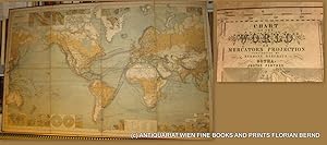
WORLD MAP- 1879 // Chart of the world on Mercators projection : containing the lines of oceanic mail steam communication and overland routes, the international aerial and submarine telegraphs, and the principal tracks of sailing vessels, showing some continental surface characteristics, the oceanic currents and important deep-sea soundings, with 33 additional charts and plans showing the general currents of air, and the lines of equal magnetic variation, the Tehuantepec, Honduras, Nicaragua, Panama, Darien, and Suez routes, several sea ports, the telegraphic and steam lines round the world = Chart of the world zur Übersicht der regelmässigen Dampfschifffahrts-Linien und Überland-Routen, der internationalen Land- und Untersee-Telegraphen, so
Berghaus, Hermann [Stülpnagel, Friedrich von]:
Verlag: Perthes, Gotha, 1879
Karte
Zustand: Gebraucht
Hardcover
Verkauft von ANTIQUARIAT.WIEN Fine Books & Prints, Wien, Österreich
Verbandsmitglied:
AbeBooks-Verkäufer seit 4. August 2003
Verkäuferbewertung 5 von 5 Sternen
![]()
Gebraucht - Hardcover
Preis:
EUR 1.380,50
Währung umrechnen
EUR 43,00
für den Versand von Österreich nach USA
Versandziele, Kosten & Dauer
Anzahl: 1 verfügbar
In den Warenkorb legen