Beschreibung
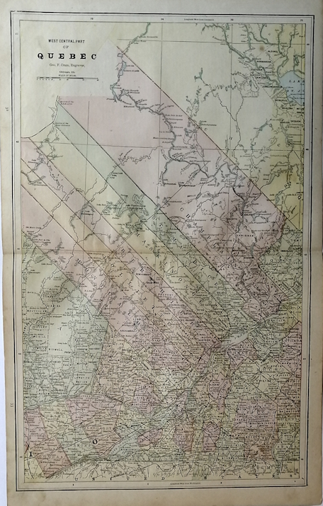
Engraved by George Cram , 1888. Overall Size including text and borders : 21 3/4 x 13 1/2 ins. Actual Map Size: 11 3/4 x 18 1/8 ins. CONDITION: Folded in the middle with text on the back. . The map illustrates the west-central part of Quebec, showcasing both natural and administrative features. The region is characterized by a dense network of townships, each clearly labeled and divided by fine lines, reflecting a historical or administrative survey. The southern portion is more populated, with multiple towns and cities connected by roads and railways, indicating developed infrastructure. In contrast, the northern section is more rural, featuring fewer settlements and larger expanses of forests, lakes, and rivers. The map s color-coding highlights different administrative divisions or townships, with distinct shadings to differentiate areas. Natural features include various lakes, rivers, and landforms, with the Saint Lawrence River prominently running horizontally through several major townships, emphasizing its historical importance for trade and transportation. The map also incorporates a grid system with longitudinal and latitudinal markings, as well as a mileage scale for distance measurement. Overall, the map provides a detailed representation of west-central Quebec, blending natural geography with human settlement and administrative boundaries, giving insight into the region s historical landscape and development. NOTE THE FOLLOWING BEFORE YOU PURCHASE: This is a GENUINE ANTIQUE VINTAGE 1880s MAP. It is NOT a modern reproduction, ie. a laser scan, photocopy, etc. It is the original from the antique or vintage atlas or book publication. This map was published on the date mentioned, or circa the date mentioned at the top of the page. The map I have for sale, like many antique vintage prints and maps that you see online, originate from an antique vintage book or atlas publication. The publication may not always be known. If you have any questions, emails are welcome. Shipped Unmatted. Bestandsnummer des Verk�ufers 1956
Verk�ufer kontaktieren
Diesen Artikel melden
