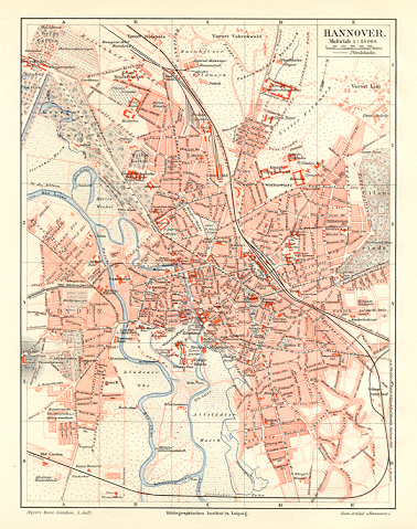
1890s Color Map of Hanover in Germany , shows German Railways
Verkauft von Artisans-lane Maps & Prints, Victoria, BC, Kanada
AbeBooks-Verkäufer seit 25. August 2021
Gebraucht
Zustand: Gebraucht - Gut
Anzahl: 1 verfügbar
In den Warenkorb legenVerkauft von Artisans-lane Maps & Prints, Victoria, BC, Kanada
AbeBooks-Verkäufer seit 25. August 2021
Zustand: Gebraucht - Gut
Anzahl: 1 verfügbar
In den Warenkorb legen1890s Color Map Germany Hanover City, German Railways ,1894 Antique Colour Map TOPOGRAPHICAL RELIEF MAP RAILWAY AND ROUTE MAPThe 1890s city plan of Hanover, Germany aimed to create a modern, well-organized urban environment to accommodate the city's rapid growth and expanding population of around 300,000 people. The plan included the construction of new streets, boulevards, and public squares, as well as the expansion of existing infrastructure such as water and sewage systems. One of the key features of the plan was the creation of a ring road around the city center to ease traffic congestion and provide access to surrounding neighborhoods, which was also intended to serve as a green belt with parks and gardens. The development of new residential neighborhoods that were self-contained and socially mixed was also a significant aspect of the plan. Additionally, new public buildings such as the City Hall and Opera House were constructed, designed to be architecturally impressive and symbolize the city's growing wealth and importance. Overall, the 1890s city plan of Hanover was comprehensive and forward-thinking, shaping the city's development for decades to come.COMES WITH A SEPERATE INDEX PAGE INDICATING STREETS AND SITES. 1890s Wood Engraving, Antique Map Approximate Overall Size: 8 X 9 1/2 inches CONDITION: Book Plate Map - Excellent Condition. Folded. As Scanned. German Text. Beautiful with excellent detail. Map Print is Blank on the back . NOTE THE FOLLOWING BEFORE YOU PURCHASE: This is a GENUINE ANTIQUE PRINT. It is NOT a modern reproduction, ie. a laser scan, photocopy etc. It is the original from the antique atlas or book publication. This map/print was published on the date mentioned, or circa of the date mentioned at the top of the page. The print/map I have for sale, like many antique maps and prints that you see online, originate from an antique book or atlas publication. The publication may not always be known. If you have any questions, emails are welcome.
Bestandsnummer des Verkäufers 6918
Satisfaction Gauranteed. Postage is extra. We are pleased to accept Visa, Mastercard, American Express or Paypal.
Orders are processed and ship within 3 business days.
The shipping prices quoted reflect what we have found to be the average cost. These prices include all packaging and handling which is done with the utmost care. We use foamcore for added protection. There are times when we need to requote shipping as we offer combined shipping charges for multiple items. If you have any questions, emails are welcome. Rest assured we try to get your order to you as quickly as possible.