


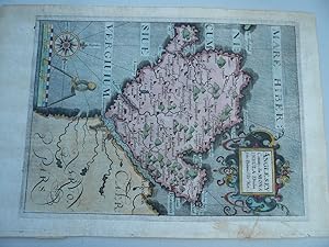
Anglesey Comitatus, olim Mona Insula Drindum Sedes, Britannice Tir Mon Method Copper engraved with hand colour Artist Hole, William after Saxton, Christopher Published [c. 1637] Dimensions 253 x 182 mm Notes Lovely hand coloured map of Anglesey from William Camden's great Renaissance work 'Britannia' which was originally published in Latin, in 1586 with only a general map, providing a historical and topographical study of Great Britain.
Hole William
Erscheinungsdatum: 1637
Kunst / Grafik / Poster
Zustand: Ausreichend
Verk�ufer Hammelburger Antiquariat, Hammelburg, Deutschland
Verk�uferbewertung 4 von 5 Sternen
![]()
AbeBooks-Verk�ufer seit 22. September 2015
Gebraucht -
Preis:
EUR 170,00
W�hrung umrechnen
EUR 30,00
f�r den Versand von Deutschland nach USA
Versandziele, Kosten & Dauer
Anzahl: 1 verf�gbar
In den Warenkorb legen