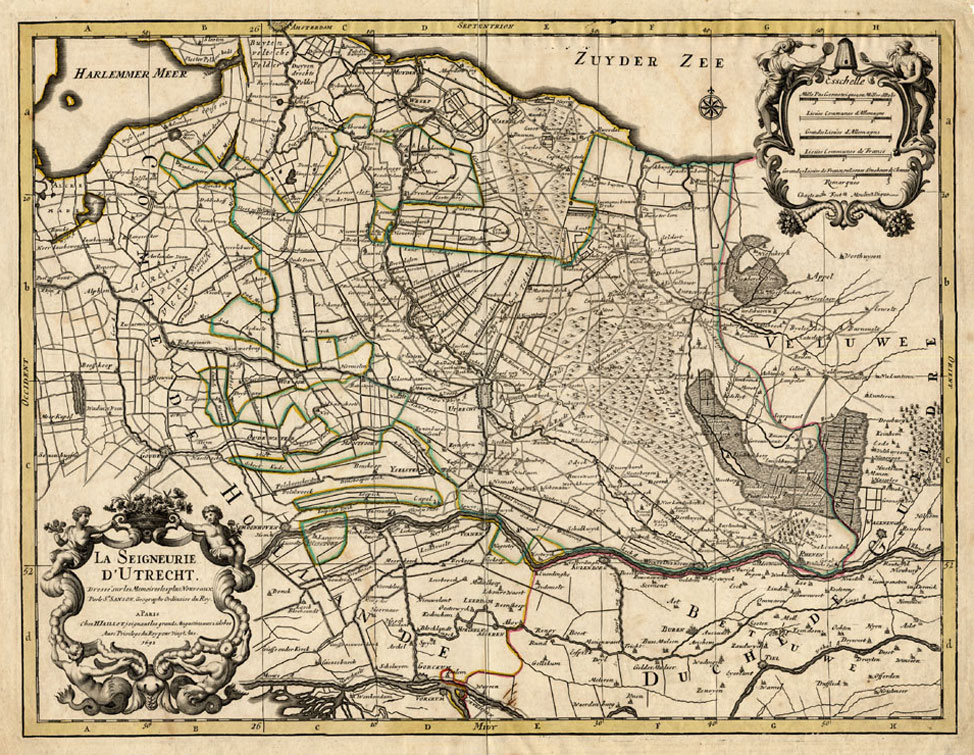
Antique Map-UTRECHT-NETHERLANDS-Sanson-Jaillot-1692
Verkäufer Pictura Prints, Art & Books, Overasselt, Niederlande
Verkäuferbewertung 5 von 5 Sternen
AbeBooks-Verkäufer seit 1. November 2019
Verkäufer Pictura Prints, Art & Books, Overasselt, Niederlande
Verkäuferbewertung 5 von 5 Sternen
AbeBooks-Verkäufer seit 1. November 2019
Beschreibung
Original copperplate engraving on a verge type hand laid paper. on paper. Size in cm: The overall size is ca. 59 x 46.5 cm. The image size is ca. 56 x 42.5 cm. Size in inch: The overall size is ca. 23.2 x 18.3 inch. The image size is ca. 22 x 16.7 inch.Map: 'La Seigneurie d'Utrecht -' (Map of the Province of Utrecht, the Netherlands.) The orientation of this map is North. This detailed map shows the present day Province of Utrecht, Het Gooi and parts of Noord-Holland up to Amsterdam. This plan originates from: 'Atlas Nouveau .', published by H. Jaillot, 1674 and later.Artists and Engravers: The publisher of this map was Alexis Hubert Jaillot (1632-1712) , was a French sculptor, engraver, publisher and cartographer. Native of Franch-Comtà  , followed his elder brother, Pierre Simon to Paris in 1657. From 1664 he was student at the St. Lucas Academy. In 1665 he was created Sculpteur du Roi & in 1678, Sculpteur & Geographe ordinaire du Roi, official geographer to King Louis XIV. He worked closely with the heirs of Nicolas Sanson, Guillaume & Adrien Sanson, in the late 1660's and early 1670's. His most famous works include the Atlas Nouveau, first published in 1674 (reissued in numerous editions, including Dutch editions by Mortier and Covens and Mortier) and Neptune Franà §ois (1692) and Atlas Franà §ais (1695). He also reissued the series of 4 Willem Blaeu Continental Wall maps in about 1669 with French border texts. The family remained closely involved in cartography, Alexis Hubert being succeeded by his son, Bernard Jean Hyacinthe Jaillot (1673-1739) and grandson, Bernard Antoine Jaillot (d.1749) and the latter's brother-in-law, Jean Baptiste-Michel Renou de Chauvignà  -Jaillot (1710-1780). At the latter's death, the stock of Jaillot was liquidated in auction in 1781, most being melted down. However a few plates were purchased by the French cartographer Jean-Claude Dezauche, which appeared in his Catalogue of November 1781 and Desnos, who in 1789 reissued the 6-sheet map of Asia by Sanson-Jaillot.Condition: Good. General age related toning and some light staining from handling. No rear text. Occasional small tears in paper edges, backed, not effecting image. Middle fold as issued. Separated lower middle fold, backed and barely visible.Keywords: ANTIQUE MAP-UTRECHT-NETHERLANDS-SANSON-JAILLOTXXX-B4-08. Bestandsnummer des Verkäufers bb04541
Bibliografische Details
Titel: Antique ...
Erscheinungsdatum: 1692
Anbieterinformationen
Pictura Prints guarantees the items to be as described. We always add scans or photographs to our listings. Further information is possibly available on request. Certificates of autenticity (COA) can be provided on request. We use a margin tax treatment.
We ship worldwide and package our items meticulously. We carry an umbrella insurance policy. Our shipment rates are based on shipments up to 1 kg. For heavier shipments we will contact you with a quote. Currently our surcharge for international shipments over 1 kg is 9,14 euro / kg. In addition POST NL temporarly charges 3,60 euro per kg due to CORONA related logistics. We ship by registered mail through POST NL. Expedited shipping or shipment through another carrier is available on request at a possible surcharge.
Zahlungsarten
akzeptiert von diesem Verkäufer