
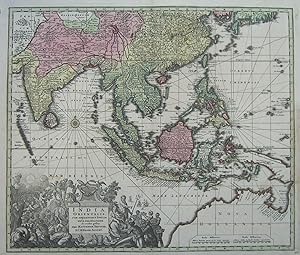
India orientalis, cum adjacentibus insulis.
ASIEN / OSTINDIEN / SOUTH EASTERN ASIA. Seutter, M.:
Verlag: Augsburg: Seutter ca. ,, 1735
Gebraucht
Verk�ufer
Antiquariat Ruthild J�ger, Lueneburg, Deutschland
Verk�uferbewertung 3 von 5 Sternen
![]()
AbeBooks-Verk�ufer seit 23. Juni 2015
Dieses Exemplar ist nicht mehr verf�gbar. Hier sind die �hnlichsten Treffer f�r India orientalis, cum adjacentibus insulis..
Beschreibung
Beschreibung:
Altkolor. Kupferstichkarte, 58 x 49 cm. Sehr gut erhalten / in very good condition. * Tooley: Early maps of Australia 74; Tooley: Printed maps of Australia 1137; Parry: East Indian Islands 223. Sehr dekorative Karte des s�dostasiatischen Raumes, vom indischen Subkontinent und Ceylon bis S�d-Japan, Philippinen, Indonesien, Papua und zu der durch die Niederl�nder entdeckten K�ste Nord-Australiens reichend, in Bildmitte Sumatra; mit gro�er fig�rlicher und reich verzierter Kartusche (30 x 14 cm). Plattenzustand noch vor dem Privilegvermerk (1740). A very fine example of this Southeast Asia map, in contemporary colouring; it extends from Southern Japan to the Dutch discoveries in Northern Australia, and includes India, Ceylon, Southern China and all the East Indian archipelago. The map shows an elongated coast of New Guinea conjoined with the Northern coast of Australia. The map is embellished by a wonderfully elaborate and highly decorative allegorical cartouche (30 x 14 cm) showing in symbolic form the religious, commercial and maritime riches of the region, with native figures and European travellers. "One of the most sought after . 18th century maps of Southeast Asia and the East Indian Islands" (P.). (#1009AG). Bestandsnummer des Verk�ufers 1009AG
Bibliografische Details
Titel: India orientalis, cum adjacentibus insulis.
Verlag: Augsburg: Seutter ca. ,
Erscheinungsdatum: 1735
Beste Suchergebnisse bei AbeBooks

Foto des Verk�ufers
Kupferstich- Karte, b. M. Seutter, "India orientalis, cum adjacentibus Insulis nova delineatione ob oculus posita per Matthaeum Seutter. S.C. M. Geogr. August".
Gebraucht
Anbieter: Antiquariat Clemens Paulusch GmbH, Berlin, Deutschland
Verk�uferbewertung 5 von 5 Sternen
![]()
mit altem Fl�chenkolorit, nach 1742, 48 x 57 Tooley, Early maps of Australia, Nr. 74: "North Australia shown bottom right with 29 names" und ders: Printed maps of Australia, Nr. 1137. - Hier Ausgabe mit dem Druckprivileg ( d.h. nach 1742 ), aber ohne Stecherangabe von A. Silbereisen. - Zeigt das Gebiet zwischen Indien und Japan mit Indochina, Indonesien und den Philippinen im Zentrum. Rechts unten gro�e Teile von Nordwest Australien. Unten links dek, gro�e Kartusche. Bestandsnummer des Verk�ufers 73783
Anzahl: 1 verf�gbar
Foto des Verk�ufers
India Orientalis, cum Adjacentibus Insulis Nova Delineatione ob oculos posita per Matthaeum Seutter, S.C. M. Geogr. August
Verlag:
Seutter, Augsburg, 1740
Gebraucht
Anbieter: Antipodean Books, Maps & Prints, ABAA, Garrison, NY, USA
Verk�uferbewertung 3 von 5 Sternen
![]()
Map of the East Indies with Australia shown from west coast to Gulf of Carpentaria. Relief shown pictorially. 22 names are noted on the North coast of Australia, with a notation on the west coast of Australia "And. Silbereisen. sc. 30." Elaborate pictorial cartouche with Neptune, people, cherubs and animals. Attractive color. 49 x 57 cm. Tooley p. 143, no. 1136. Bestandsnummer des Verk�ufers 12062
Anzahl: 1 verf�gbar
Foto des Verk�ufers
India Orientalis cum Adjacentibus Insulis Nova Delineatione ob oculos posita. [India, Asia]
Gebraucht
Anbieter: Art Source International Inc., Boulder, CO, USA
Verk�uferbewertung 3 von 5 Sternen
![]()
Decorative map of south-east Asia from India to the southern coastline of Japan. To the south is the northern coasline of Australia, still connected to New Guinea by Carpentaria, with over thirty named features. The elaborate title cartouche has two themes: on the left is a missionary converting the natives; on the right are more natives offering exotic gifts such as ivory and coral as tribute to a personification of Europe, while Neptune gestures to the sea signifying European domination of it. Extremely strong engraving which indicated an early printing. One of the most difficult maps of this area to be found since the map was included in only a few of his atlases. This map measures 22 inches by 19 inches. Bestandsnummer des Verk�ufers 74500
Anzahl: 1 verf�gbar