Beschreibung
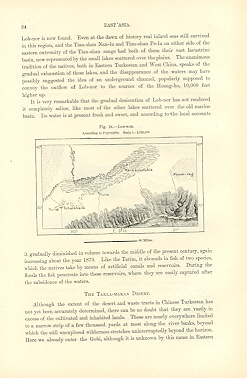
LOB-NOR,The Tarim Basin,Chinese Turkestan,Chinese Empire,East Asia,1800s Antique Map LOB-NOR,The Tarim Basin,Chinese Turkestan,Chinese Empire,East Asia,1800s Antique Map 1890s HISTORICAL RELIEF MAP CHART SHOWING LOCAL TOPOGRAPHY AND ENVIRONS LOP-NOR or LOB-NOR, a lake of Central Asia, in the Gobi Desert, between the Astin-tagh (Altyn-tagh) on the south and the Kuruk-tagh on the north. Previous to 1876 it was placed in nearly all maps at 42 30' N., a position which agreed with the accounts and the maps of ancient Chinese geographers. In the year mentioned the Russian explorer Przhevalsky discovered two closely connected lake-basins, Kara-buran and Kara-koshun, fully one degree farther south, and considerably east of the site of the old Lop-nor, which lake-basins he nevertheless regarded as being identical with the old Lop-nor of the Chinese. But the water they contained he pronounced to be fresh water. This identification was disputed by Baron von Richthofen, on the ground that the Lop-nor, the " Salt Lake " of the Chinese geographers, could not be filled with fresh water; moreover, being the final gathering basin of the desert stream, the Tarim, it was bound to be salt, more especially as the lake had no outflow. Przhevalsky visited the Lop-nor region again in 1885, and adhered to his opinion. But ten years later it was explored anew by Dr Sven Hedin, who ascertained that the Tarim empties part of its waters into another lake, or rather string of lakes (Avullu-kol, Kara-kol, Tayek-kol and Ark a-kol), which are situated in 42 30' N., and thus so far justified the views of von Richthofen, and confirmed the Chinese accounts. At the same time he advanced reasons for believing that Przhevalsky's lake-basins, the southern Lop-nor, are of quite recent originindeed, he fixed upon 1720 as the probably approximate date of their formation, a date which von Richthofen would alter to 1750. Besides this, Sven Hedin argued that there exists a close inter-relation between the northern Lop-nor lakes and the southern Lop-nor lakes, so that as the water in the one group increases, it decreases to the same proportion and volume in the other. He also argued that the four lakes of northern Lop-nor are slowly moving westwards under the incessant impetus of wind and sandstorm (buran). These conclusions were afterwards controverted by the Russian traveller P. K. Kozlov, who visited the Lop-nor region in 1893-1894 that is, before Dr Sven Hedin's examination. 1890s Wood Engraving, 1800s Antique Map Approximate Overall Size: 7 X 10 1/2 inches CONDITION: Book Plate INTEXT MAP - Excellent Condition. Beautiful with excellent detail. There is Text on Front and Back Side.
Bestandsnummer des Verk�ufers 8031
Verk�ufer kontaktieren
Diesen Artikel melden


