
Map of China (China Regnum)
Gerard and Cornelis de Jode
Verlag: Antwerp, 1593
Gebraucht
Verkäufer
Trillium Antique Prints & Rare Books, Franklin, TN, USA
Verkäuferbewertung 4 von 5 Sternen
![]()
AbeBooks-Verkäufer seit 6. März 2017
Dieses Exemplar ist nicht mehr verfügbar. Hier sind die ähnlichsten Treffer für Map of China (China Regnum).
Beschreibung
Beschreibung:
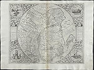
This map is one of the most rare and sought after maps of China entitled China Regnum. It was the first de Jode map of China. It mapped China, part of Japan, Korea, Taiwan, and northern Philippines. It was based on the work of Jorge de Barbuda, a Portuguese cartographer, whose map appeared in Ortelius's 1584 publication of Theatrum. It was the second map of China to be printed in Europe.Description of the work:This truly significant map is from one of the rarest atlases ever published, Gerard and Cornelis de Jode's Speculum orbis Terrae. The work was published in Antwerp in 1593 by Arnold Coninx for the widow and heirs. This is considered the second edition, revised an expanded. The first edition was published in 1578. Van Ortroy knew of only 14 copies of the second edition being published. (Skelton, Introduction to the facsimile editions)De Jode drew upon his large stock of maps from Italian, German, and Flemish cartographers to create his atlas. He engraved some of the maps and his brothers, Joannes and Lucas van Deutecum, also contributed to the process. The second edition included additional maps from Gerard's son Cornelis. The maps have descriptive text to verso in Latin. The text for the first edition was written by the German scholar, Daniel Cellarius.The atlas contained some of the most groundbreaking maps ever published. The maps of the world, Americas, Australia, and China are of particular note and remain some of the most important maps ever published. While it may not have had commercial success at the time, it is considered a masterpiece of 16th century cartography. Very few examples of the maps have survived from either edition.Gerard de Jode (1521- 1591) was a Flemish cartographer, printer, and engraver. He produced and sold many maps in Antwerp, but his legacy lies in his outstanding atlas, Speculum Orbis Terrarum. De Jode was a contemporary and competitor of Abraham Ortelius. Ortelius was believed to have been responsible for delaying de Jode's work so his atlas Theatrum Orbis Terrarum would precede de Jode's. Because Ortelius's atlas had 8 years on the market it was well established and thus de Jode's atlas did not sell very well.To compete with Ortelius, de Jode worked on the second revised and expanded edition. De Jode's wife and son, Cornelis (1568-1600) took over the publishing upon Gerard's death in 1591. Cornelis prepared ten new maps of the World, North America, China, Australia and Alaska and re-issued the atlas. "Many of de Jodeâ s maps are judged to be superior to those of Ortelius, both in detail and style." (Burden)Antwerp publisher Joan Baptista Vrients purchased the plates after Cornelis's death. He also acquired Ortelius's plates for Theatrum Orbis Terrarum to which he gave priority. It is likely he bought de Jode's plates to prevent any further editions of Speculum of course only increasing the intrigue and worth of the maps today."Although the atlas may not have appealed to the public, it was admired by other cartographers. As evidence, Petrus Montanus mentions it in the same breath with Mercatorâ s Atlas and Orteliusâ Theatrum in his preface to Pieter Kaeriusâ Germaniae inferior (Wardington Catalogue), Michael von Aitzing refers to it in his work, DeLeone Belgico (1583). Von Aitzing intended his work to act also as a supplement to both the Theatrum of Ortelius and the Speculum of De Jode." (Burden)Provenance : Ownership inscription at the bottom of the title page ex Bibliotheca Prim d Federici 1600.References: Van der Krogt 32:02B (titles 32:2A and 32:2B) ; Koeman II, Jod 2 ; Shirley, The mapping of the world, 165,184 ; Burden, The mapping of America, 81, 82 ; Symour, L. Schwartz, Ehrenberg, The mapping of America, pp. 78-79 ; Norwich, Maps of Africa 19 ; Navari, Maps of Cyprus, 29 ; Tooley, Dictionnary of mapmakers II, p. 441 ; Tooley, Mapping of Australia,; Tooley, Arabia in early maps, 38 (1st ed.) ; Koeman, Schilder, van Egmond, van der Krogt, HOC,vol. 3 part 2, Commerc. Bestandsnummer des Verkäufers de-jode000
Bibliografische Details
Titel: Map of China (China Regnum)
Verlag: Antwerp
Erscheinungsdatum: 1593
Zustand: Fine
Beste Suchergebnisse bei AbeBooks

Iaponia Regnum, anno 1655, M.Martini, published by Blaeu J. Coppermap, published by J. Blaeu Amsterdam, anno 1655, old coloured in outline, size of the map: 41,5 x 56,5 cm., little brwonish, little crack on upper margin. Korea being correctly drawn as a peninsula for the first time. This map was the standart map up to the 18 century. From M. Martini, "Novus Atlas Sinensis", an italian Jesuit, the first european Atlas of China and Japan. Reference: Map Collectors Circle, Nr. 36, 21: "The subdivisions of the Kingdom are shown by means of dotted lines; Korea being correctly drawn as a peninsula for the first time. This was to remain the standart form of Japan until the eighteenth century and although replaced by the maps of Reland and Kaempfe
Gebraucht
Anbieter: Hammelburger Antiquariat, Hammelburg, Deutschland
Verkäuferbewertung 4 von 5 Sternen
![]()
Kein Einband. Zustand: Ausreichend. Iaponia Regnum, anno 1655, M.Martini, published by Blaeu J. Coppermap, published by J. Blaeu Amsterdam, anno 1655, old coloured in outline, size of the map: 41,5 x 56,5 cm., little brwonish, little crack on upper margin. Korea being correctly drawn as a peninsula for the first time. This map was the standart map up to the 18 century. From M. Martini, "Novus Atlas Sinensis", an italian Jesuit, the first european Atlas of China and Japan. Reference: Map Collectors Circle, Nr. 36, 21: "The subdivisions of the Kingdom are shown by means of dotted lines; Korea being correctly drawn as a peninsula for the first time. This was to remain the standart form of Japan until the eighteenth century and although replaced by the maps of Reland and Kaempfer it is in its outline closer to the true shape of Japan than either of these or indeed any printed map before the nineteenth century. It was compiled by Father Martino Martini, an Italian Jesuit, and appears in Blaeu´s Atlas Sinensis, the first European atlas of China. Of the two general maps one if of Japan. Father Martini (1614-1661) went to China as a young man and became the Superior at Hang-Chow. In 1651 he left for Rome but took three years on an eventful journey home. His arrival was described by Blaeu: ""The Reverend Father Martinus Martinius comes from India, and brings with him the figurations and descriptions of the Empire of China. He insists that I print and publish these. Therefore i leave off all other things for the time being, in order to push forward this work "". After a short stay in Europe Martini returned to China and died in Hang-chow.". Bestandsnummer des Verkäufers ABE-1660468389660
Anzahl: 1 verfügbar