
Map of Hindoostan or India
David H. Burr
Verlag: New York, 1836
Gebraucht
Verkäufer
Trillium Antique Prints & Rare Books, Franklin, TN, USA
Verkäuferbewertung 4 von 5 Sternen
![]()
AbeBooks-Verkäufer seit 6. März 2017
Dieses Exemplar ist nicht mehr verfügbar. Hier sind die ähnlichsten Treffer für Map of Hindoostan or India.
Beschreibung
Beschreibung:
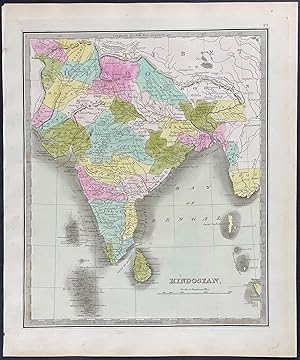
This hand-colored map is from David H. Burr's "A New Universal Atlas; comprising separate maps of all the principal empires, kingdoms & states throughout the world: and forming a distinct atlas of the United States . a new edition revised and corrected to the present time". The work was published in New York in 1836 by William Hall & Co. The maps from the work were engraved by Thomas Illman and Edward Pillbrow. --- David H. Burr (1803-1875) was one of the greatest early American mapmakers. He was born in Connecticut and began his career leading road surveys in southern New York. In 1829, he was responsible for revising Simeon De Witt's map of New York State from 1804. He also served as the topographer for the United States Post Office Department. --- Provenance: Julia H. Alexander (pencilled signature) to original bookend. --- The work is in very good to excellent condition overall. There may be a few minor imperfections or faint marks to be expected with age. Please review the image carefully for condition and contact us with any questions. --- Paper Size ~ 12 1/4" by 14 1/2". Bestandsnummer des Verkäufers burr024
Bibliografische Details
Titel: Map of Hindoostan or India
Verlag: New York
Erscheinungsdatum: 1836
Zustand: Fine
Beste Suchergebnisse bei AbeBooks

A New Map of Palestine or the Holy Land [with inset] Map of Modern Jerusalem [verso with] a Map of Hindoostan, Farther India, China, and Tibet
Verlag:
[W.M. Bradley], [Philadelphia], 1886
Gebraucht
Anbieter: Kaaterskill Books, ABAA/ILAB, East Jewett, NY, USA
Verkäuferbewertung 5 von 5 Sternen
![]()
Hand colored map. Plate 117: New Map of Palestine or the Holy Land [with inset] Map of Modern Jerusalem, drawn & engraved by W.H. Gamble, Philadelphia. Copyright by S. Augustus Mitchell 1884. 11.5 x 14 inches. [On verso] Plate 118: Map of Hindoostan, Farther India, China, and Tibet, constructed & engraved by W. Williams, Philadelphia. Copyright by S. Augustus Mitchell 1884. 13.75 x 11.25 inches. From: Mitchell's New General Atlas, Containing Maps Of The Various Countries Of The World, Plans Of Cities, Etc., Embraced In Ninety-Three Quarto Maps, Forming A Series Of One Hundred and Forty-seven Maps and Plans, Together With Valuable Statistical Tables. Also, A List Of Post-Offices Of The United States And Territories, And Also Census Of 1880 For States, Territories And Counties, Also Of Cities Of Over 10,000 Inhabitants. Philadelphia: Published By Wm. M. Bradley & Bro., No. 1026 Arch Street. 1886. Very good, light soiling, primarily to margins, one edge tear, not affecting contents. Bestandsnummer des Verkäufers 45701
Anzahl: 1 verfügbar