
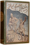
Vintage Map of Iran / Persia: "Perse" [showing the whole of Iran from the Caspian Sea to the Gulf of Basra (Golfe de Balsora) / Persian Gulf].
Middle East - Fer, Nicholas de / [Nicolas de Fer]. (1646 - 1720)
Verlag: [Paris], c. 1700., 1700
Gebraucht
Verk�ufer
Inanna Rare Books Ltd., Skibbereen, CORK, Irland
Verk�uferbewertung 5 von 5 Sternen
![]()
AbeBooks-Verk�ufer seit 25. Oktober 2019
Dieses Buch ist nicht mehr verf�gbar. AbeBooks f�hrt Millionen von B�chern. Bitte geben Sie unten Suchbegriffe ein, um �hnliche Exemplare zu finden.
Beschreibung
Beschreibung:
Original copper engraved maps. 15.5 cm wide x 13 cm high. Mounted on paper. Very good condition. From a wonderful collection of Maps from an old english library (South Shields) - with a tiny library stamp to the mounting paper (The stamp is NOT on the Map). Nicolas de Fer (1646 25 October 1720) was a French cartographer and geographer. De Fer was the youngest of three sons of Antoine de Fer, who was also a cartographer. When he was 12, he became the apprentice of Parisian engraver Louis Spirinx, and made his first map, of the Canal du Midi, at the age of 23. After the death of his father in June 1673, his mother Genevi�ve initially took over the map making company, which had begun to decline. She passed it and the atelier, called Quai de L'Horloge, on to Nicolas in 1687 because of her old age. De Fer was so successful at improving the firm that, in 1690, he became the official geographer to Louis, Dauphin of France. With support from the Spanish and French Royal Families, de Fer also became official geographer for Philip V and Louis XIV, the kings of Spain and France, respectively. Because of this, his maps became Bourbon propaganda, endorsing French King Louis XIV. His business flourished, producing town plans, atlases, wall maps, and more than 600 sheet maps. He made maps of places in Europe and North America, including New Spain, places fortified by Vauban, the Low Countries, and the War of the Spanish Succession. In 1698, de Fer published a map of North America, which included a depiction of beavers building dams near Niagara Falls. Seventeen years later, Herman Moll published a map which plagiarized elements of de Fer's work, particularly the beaver scene. It became known as the "Beaver map". De Fer became the official geographer for His Catholic Majesty in 1720. Two of his sons-in-law, Guillaume Danet and Jaques-Fran�ois B�nard, continued the company after de Fer's death on 25 October of that year until around 1760. (Wikipedia). Bestandsnummer des Verk�ufers 403AG
Bibliografische Details
Titel: Vintage Map of Iran / Persia: "Perse" [...
Verlag: [Paris], c. 1700.
Erscheinungsdatum: 1700
AbeBooks ist ein Internet-Marktplatz f�r neue, gebrauchte, antiquarische und vergriffene B�cher. Bei uns finden Sie Tausende professioneller Buchh�ndler weltweit und Millionen B�cher. Einkaufen bei AbeBooks ist einfach und zu 100% sicher — Suchen Sie nach Ihrem Buch, erwerben Sie es �ber unsere sichere Kaufabwicklung und erhalten Sie Ihr Buch direkt vom H�ndler.
Millionen neuer und gebrauchter B�cher bei tausenden Anbietern
Neue und gebrauchte B�cher

Neue und gebrauchte Exemplare von Neuerscheinungen, Bestsellern und preisgekr�nten B�chern. Eine riesige Auswahl an g�nstigen B�chern.
Antiquarische B�cher
Von seltenen Erstausgaben bis hin zu begehrten signierten Ausgaben ? bei AbeBooks finden Sie eine gro�e Anzahl seltener, wertvoller B�cher und Sammlerst�cke.
Versandkostenfreie B�cher
Hier finden Sie viele hunderttausend neue, gebrauchte und antiquarische B�cher, die Ihnen unsere deutschen und internationalen H�ndler versandkostenfrei liefern.