Beschreibung
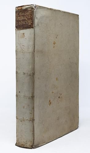
THE TEMPELHOFF COPY. First Latin edition. Leiden: Elzevir, 1633. Folio in 6s (13 1/4" x 8 3/4", 215mm x 339mm). [Full collation available.] With 14 engraved double-page maps and many in-text woodcut illustrations. Bound in contemporary vellum with yapp edges. On the spine, author and title gilt to calf. Marbled end-papers. All edges of the text-block glazed black. Splits to the head- and tail-pieces, with the front hinge starting at the head. Some small splits and soiling to the extremities, with some spotting to the boards. End-papers renewed (XIXc?). Foxing throughout, with some heavier passages. Wear to hinges, with loss of matter to backstrip and cover edges. Annotations in ink throughout: underscoring, marginal notation, a list of memoranda with page numbers to the recto of the rear free end-paper. Note regarding the author tipped in before the title-page, signed "Georg: Sam: Tempelhoff." Johannes de Laet (1581-1649), was born in Antwerp to cloth merchant Hans de Laet. In 1584, upon the invasion of Antwerp by Spanish troops, his family fled to the Northern Netherlands and settled in Amsterdam. At the University of Leiden, he studied philosophy and theology, matriculating in 1597. His worldly interests led him to London in 1603, where he cleverly invested in Dutch land reclamation projection and overseas trade. His success in his field led him to become one of the founding directors of the Dutch West India Company- a position he held from 1620 until death. De Laet first published his account of the New World as Nieuwe Wereldt ofte Beschrijvinghe van West-Indien. (Leiden, 1625). This Latin edition, probably translated by de Laet himself, is one of the most important seventeenth-century New World histories and texts concerning early knowledge of the Americas. The "Nova Anglia" map, showing the coast and inland areas from Nova Scotia to North Carolina, is the first printed map to mention the name Manhattan, here spelled "Manbattes." "It is also the earliest to use the Dutch names of Noordt Rivier and Zuyd Rivier, for the Hudson and Delaware Rivers respectively, as well as the Indian Massachusets, for the new English colony . [the 'Nova Francia' map] is one of the foundation maps of Canada" (Streeter). It is "one of the most famous contemporary descriptions of the natural history of the New World. The work was highly praised a century later by Charlevoix, attesting to its accuracy [.] Winsor referred to Laet's book as the standard seventeenth-century work on New Netherland" (ibid.). The fourteen double-page maps are the work of Hessel Gerritsz, a Dutch engraver who was appointed official cartographer of both Dutch India Companies (over Blaeu). Georg Samuel Tempelhoff (1711-1775) was a Prussian career civil servant and father to the more famous Georg Friedrich von Tempelhoff (1737-1807), mathematician, scientist, and musician. Georg Samuel was a councilor (Amtsrat) who leased land near Eberswalde and Beeskow; it is on this foundation that his son, who was ennobled in 1784, built his success and, doubtless, his library. Alden & Landis 633/65; Borba de Moraes I.451; Burden 229-232; Cumming Southeast 34; Phillips 1149; Rodrigues, 1352; Sabin 38557; Schwartz & Ehrenberg, p. 105; Streeter sale 37; Willems 382. Bestandsnummer des Verkäufers SJF0006
Verkäufer kontaktieren
Diesen Artikel melden
![]()


