
Gesamtpreis (1 Artikel Artikel):
Versandziel:

andriveau goujon eugene (92 Ergebnisse)
Produktart
- Alle Product Types
- Bücher (5)
- Magazine & Zeitschriften
- Comics
- Noten
- Kunst, Grafik & Poster (80)
- Fotografien
- Karten (6)
- Manuskripte & Papierantiquitäten (1)
Zustand
Einband
Weitere Eigenschaften
- Erstausgabe
- Signiert (1)
- Schutzumschlag
- Angebotsfoto (85)
- Keine Print-on-Demand Angebote (92)
Gratisversand
- Versand nach USA gratis
Land des Verkäufers
Verkäuferbewertung
-
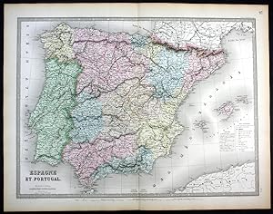
"Espagne et Portugal" - Spain Espana Spanien Portugal map Karte
Verlag: Paris, 1862
Anbieter: Antiquariat Steffen Völkel GmbH, Seubersdorf, Deutschland
Bewertung:

Karte
original handkolorierte alte Stahlstich-Landkarte von 1862 von Eugene Andriveau-Goujon (1832-1897) - Blatmasse: ca. 68 x 53 cm - gut erhalten. | original hand colored old steel engraving from 1862 by Eugene Andriveau-Goujon - size of sheet: circa 26.7 x 20.8 inches - good condition. | Dies ist ein Original! - Kein Nachdruck! - Keine Kopie! -- This is an original! - No copy! - No reprint! Sprache: Deutsch Gewicht in Gramm: 1500.
-
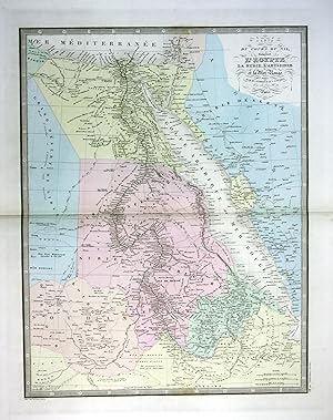
"Carte du cours du Nil comprenant l'Egypie" - Egypt Ägypten Red Sea Karte map
Verlag: Paris, 1860
Anbieter: Antiquariat Steffen Völkel GmbH, Seubersdorf, Deutschland
Bewertung:
Karte
original handkolorierte alte Stahlstich-Landkarte von ca. 1860 von Eugene Andriveau-Goujon (1832-1897) - Blatmasse: ca. 68 x 53 cm - im Mittelfalz mit Randeinriss außerhalb der Karte, sonst gut erhalten. | original hand colored old steel engraving from circa 1860 by Eugene Andriveau-Goujon - size of sheet: circa 26.7 x 20.8 inches - with marginal tear in middle fold outside the map, otherwise in good condition. | Dies ist ein Original! - Kein Nachdruck! - Keine Kopie! -- This is an original! - No copy! - No reprint! Sprache: Deutsch Gewicht in Gramm: 1500.
-
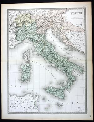
"Italie" - Italia Italy Italien Sicilia Sardegna Corse map Karte
Verlag: Paris, 1862
Anbieter: Antiquariat Steffen Völkel GmbH, Seubersdorf, Deutschland
Bewertung:
Karte
original handkolorierte alte Stahlstich-Landkarte von 1862 von Eugene Andriveau-Goujon (1832-1897) - Blatmasse: ca. 68 x 53 cm - gut erhalten. | original hand colored old steel engraving from 1862 by Eugene Andriveau-Goujon - size of sheet: circa 26.7 x 20.8 inches - good condition. | Dies ist ein Original! - Kein Nachdruck! - Keine Kopie! -- This is an original! - No copy! - No reprint! Sprache: Deutsch Gewicht in Gramm: 1500.
-

"Algerie" - Algeria Algerien North Africa Afrika map Karte
Verlag: Paris, 1862
Anbieter: Antiquariat Steffen Völkel GmbH, Seubersdorf, Deutschland
Bewertung:
Karte
original handkolorierte alte Stahlstich-Landkarte von 1862 von Eugene Andriveau-Goujon (1832-1897) - Blatmasse: je ca. 68 x 53 cm - im Falz mit Randeinriss, sonst gut erhalten. | original hand colored old steel engraving from 1862 by Eugene Andriveau-Goujon - size of sheet: each circa 26.7 x 20.8 inches - with marginal tear in middle fold, otherwise in good condition. | Dies ist ein Original! - Kein Nachdruck! - Keine Kopie! -- This is an original! - No copy! - No reprint! Sprache: Deutsch Gewicht in Gramm: 1500.
-

"Hemisphere Occidental" - America North South continent map Karte
Verlag: Paris, 1850
Anbieter: Antiquariat Steffen Völkel GmbH, Seubersdorf, Deutschland
Bewertung:
Karte
original handkolorierte alte Stahlstich-Landkarte von ca. 1850 von Eugene Andriveau-Goujon (1832-1897) - Blatmasse: ca. 68 x 53 cm - gut erhalten. | original hand colored old steel engraving from circa 1850 by Eugene Andriveau-Goujon - size of sheet: circa 26.7 x 20.8 inches - good condition. | Dies ist ein Original! - Kein Nachdruck! - Keine Kopie! -- This is an original! - No copy! - No reprint! Sprache: Deutsch Gewicht in Gramm: 1500.
-

"Oceanie" - Australia Oceania Philippines New Zealand map Karte
Verlag: Paris, 1862
Anbieter: Antiquariat Steffen Völkel GmbH, Seubersdorf, Deutschland
Bewertung:
Karte
original handkolorierte alte Stahlstich-Landkarte von 1862 von Eugene Andriveau-Goujon (1832-1897) - Blatmasse: ca. 68 x 53 cm - gut erhalten. | original hand colored old steel engraving from 1862 by Eugene Andriveau-Goujon - size of sheet: circa 26.7 x 20.8 inches - good condition. | Dies ist ein Original! - Kein Nachdruck! - Keine Kopie! -- This is an original! - No copy! - No reprint! Sprache: Deutsch Gewicht in Gramm: 1500.
-
Carte Generale De L'Afrique d'aprčs les derničres découvertes.
Verlag: Paris, France: Andriveau-Goujon., 1881
Manuskript / Papierantiquität
Zustand: Good. Four Maps 18.75" x 13.75" (per quadrant). Good with tears, toning. Some color. Text En Francais.
-

Carte Genérale de L'Algérie et de la Regénce de Tunis General Map of Algeria and Tunisia.
Verlag: Paris. 1843, 1843
Anbieter: Peter Harrington. ABA/ ILAB., London, Vereinigtes Königreich
Verbandsmitglied: ABA ILAB PBFA
Bewertung:
An attractive detailed map of the north of Algeria and Tunisia, including Malta, Sardinia and Corsica, with inset maps of Oran, Algiers, Bougie and Constantine. From the Atlas Universel Steel engraving. Later colouring. Good clean condition, good wide margins. the lower 12cm of centerfold has split, no loss Size: 51 x 39 cm. (20 x 15˝ inches).
-

Eigenh. Brief m. Unterschrift.
Verlag: Paris, 1856., 1856
Anbieter: Versandantiquariat Wolfgang Friebes, Graz, Österreich
Bewertung:
Signiert
2 S. auf Doppelblatt, 8°. Zustand: 0. Andriveau-Goujon war Herausgeber zahlreicher Atlanten und geographischer Werke. - Der Empfänger des auf Französisch abgefassten Briefes ist Jacques (Jacob) Mislin (1807-1878). Der aus ärmlichen Verhältnissen stammende Mislin konnte dank seines Onkels an der berühmten Lehranstalt von Porrentruy im Schweizer Kanton Bern studieren, wo er nicht viel später auch selbst unterrichten sollte. Der 1830 zum Priester geweihte kath. Theologe wurde 1836 auf Vermittlung des Grafen von Bombelle an den Wiener Hof berufen, wo er einer der Lehrer der Söhne von Erzherzog Franz Karl und Erzherzogin Sophie wurde und damit sowohl den zukünftigen Kaiser Franz Joseph wie auch Erzherzog Ferdinand Maximilian (später Kaiser Max von Mexiko) unterrichtete (u.a. auch in Erdkunde). Vor der Revolution von 1848 unternahm Mislin eine Pilgerreise von Wien über Budapest und Konstantinopel nach Jersusalem. Der danach erschienene Reisebericht wurde in mehrere Sprachen übersetzt und mehrfach nachgedruckt. In den folgenden Jahren leitete er die Bibliothek am Hof der Herzogin von Parma, Erzherzogin Marie Louise, wurde zum Abt von St. Maria von Deg (Ungarn), geheimer Kämmerer u. Hausprälat Papst Pius' XI., Apostolischer Pronotar, Kanoniker der Kathedrale von Großwardein, Träger zahlr. Orden (u.a. von Spanien, Parma u. des Ritterordens vom Heiligen Grab zu Jerusalem) sowie Mitglied zahlr. Akademien. Der Verfasser zahlr. Publikationen und Vertraute des belgischen Königs und des Grafen von Chambord blieb nach der Rückkehr von seiner Pilgerreise in Wien, wo er weiterhin in persönlichem Kontakt mit dem Kaiserhaus stand. - In einem numerierten, von Mislin eigenh. beschrifteten Papierumschlag. - Das erste Bl. m. Eckknick. Sprache: Französisch Gewicht in Gramm: 500.
-
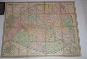
Plan de Paris a? l'echelle de 2 millim. pour 25 mčtres : indiquant les nouveaux percements et les changements de noms de voies publiques avec plans supplémentaires pour les Bois de Boulogne et de Vincennes.
Verlag: Paris : Maison Andriveau-Goujon- H.Barrčre., 1900
Zustand: Good. Original gilt stamped lcoth with map mouend on linen 85 x 110 cm. folding to 13 x 21cm.OCLC Number: 27861884 for the 1870 edition.PLAN DE PARIS 1/12.500Maison Andriveau Goujon. 190085 x110 cm, colorié, entoilé.
-

Carte gČnČrale des Etats-Unis et du Mexique comprenant l'Amerique centrale et les Antilles
Verlag: Parigi, 1870
Anbieter: libreria antiquaria perini Sas di Perini, Verona, VR, Italien
Bewertung:
Kunst / Grafik / Poster
Litografia a colori, mm 1050x610. Stato di conservazione perfetto. Piega editoriale centrale. Color litograph, mm 1050x610, very good condition. The map shows the United States during an interesting time in history. While much of the eastern half of the country is well developed, the western portion still shows unmapped regions and incomplete state boundaries. The most interesting feature in the map is the odd configuration of California and Nevada, which resulted from a misunderstanding of the boundary changes that occurred when Arizona ceded land west of the Colorado and Virgin rivers to Nevada in 1866. This map shows the Nevada/Utah border too far west and the ceded region belonging to California instead of Nevada. Dakota has yet to be divided into North and South, and the borders between Idaho, Wyoming, and Montana still have yet to come to their present.Inserts show various shipping routes between Africa, Europe and the Americas as well as the newly laid Trans-Atlantic Cables. Another insert shows the region around New York City, which had by then become one of the most active and influential cities in the World. At the bottom of the map, a reference key differentiates various European possessions within the Caribbean. Nr.cat: cod 1181.
-

Zustand: ACEPTABLE. États-Unis (Etats de lOuest) / Estados Unidos (Estados del Oeste) perteneciente al Atlas Classique et Universel de Géographie Ancienne et Moderne / Atlas Clásico y Universal de Geografía Antigua y Moderna de Eúgéne Andriveau-Goujon publicado en París en el ańo 1877. Formato (cm): 64x48.
-

Zustand: ACEPTABLE. Palestine, Ancienne & Moderne / Palestica, Antigua y Moderna perteneciente al Atlas Classique et Universel de Géographie Ancienne et Moderne / Atlas Clásico y Universal de Geografía Antigua y Moderna de Eúgéne Andriveau-Goujon publicado en París en el ańo 1877. Formato (cm): 65x49.
-

Zustand: ACEPTABLE. Espagne et Portugal / Espańa y Portugal perteneciente al Atlas Classique et Universel de Géographie Ancienne et Moderne / Atlas Clásico y Universal de Geografía Antigua y Moderna de Eúgéne Andriveau-Goujon publicado en París en el ańo 1877. Formato (cm): 49x65.
-

Zustand: ACEPTABLE. États Scandinaves / Estados Escandinavos perteneciente al Atlas Classique et Universel de Géographie Ancienne et Moderne / Atlas Clásico y Universal de Geografía Antigua y Moderna de Eúgéne Andriveau-Goujon publicado en París en el ańo 1877. Noruega - Suecia - Dinamarca Formato (cm): 66x48.
-

Zustand: ACEPTABLE. Pérou, Bolivie / Perú, Bolivia perteneciente al Atlas Classique et Universel de Géographie Ancienne et Moderne / Atlas Clásico y Universal de Geografía Antigua y Moderna de Eúgéne Andriveau-Goujon publicado en París en el ańo 1877. Formato (cm): 48x64.
-

Zustand: ACEPTABLE. Confédération Argentine et Chili / Confederación de Argentinay Chile perteneciente al Atlas Classique et Universel de Géographie Ancienne et Moderne / Atlas Clásico y Universal de Geografía Antigua y Moderna de Eúgéne Andriveau-Goujon publicado en París en el ańo 1877. Formato (cm): 63x48.
-

Zustand: ACEPTABLE. Iles Britanniques / Islas Británicas perteneciente al Atlas Classique et Universel de Géographie Ancienne et Moderne / Atlas Clásico y Universal de Geografía Antigua y Moderna de Eúgéne Andriveau-Goujon publicado en París en el ańo 1877. Formato (cm): 64x48.
-

Zustand: ACEPTABLE. Italie / Italia perteneciente al Atlas Classique et Universel de Géographie Ancienne et Moderne / Atlas Clásico y Universal de Geografía Antigua y Moderna de Eúgéne Andriveau-Goujon publicado en París en el ańo 1877. Formato (cm): 65x59.
-

Zustand: ACEPTABLE. Perteneciente al Atlas Universel, numerado 12, 15 y 24. Ejemplar en especiales buenas condiciones y de iluminación bien definida y preservada. Incluye breve Explicatión y leyenda de símbolos, ambos en el lado derecho. [Les Chemins de Fer par Alfred Potiquet] ; [Paris_Imprimerie de Louis Antoine, Rue de Cluny, 1] ; [Gravé : le Trait par Smith; les Montagnes par Gérin ; les Ecritures par P. Rousset; les Eaux par Mme. Fontaine.] . Formato (cm): 53x70.
-

Zustand: ACEPTABLE. Carte Générale du Monde Ancien représentant lesemble des Connaissances Géographiques des Grecs et des Romains / Mapa General del Mundo Antiguo en representación de todos los Conocimientos Geográficos de los Griegos y los Romanos. Perteneciente al Atlas Classique et Universel de Géographie Ancienne et Moderne / Atlas Clásico y Universal de Geografía Antigua y Modernade Eugéne Andriveau-Goujon publicado en París en el ańo 1877. Formato (cm): 39x52.
-

Zustand: ACEPTABLE. Brésil / Brasil perteneciente al Atlas Classique et Universel de Géographie Ancienne et Moderne / Atlas Clásico y Universal de Geografía Antigua y Moderna de Eúgéne Andriveau-Goujon publicado en París en el ańo 1877. Formato (cm): 64x49.
-

Zustand: ACEPTABLE. Perteneciente al Atlas Universel, numerado 49, 32 y 25. Ejemplar en especiales buenas condiciones y de iluminación bien definida y preservada. Incluye detalle de terres Australes y Iles Galapagos. [Impie. de Louis Antoine.] ; [Gravée par Smith et Gérin_Les Escritures par P. Rousset ; les Eaux par Mme. Fontaine.] . Formato (cm): 70x53.
-

Zustand: ACEPTABLE. División de las provincias de Francia. Atlas Universel, núm. 22. Formato (cm): 40x50.
-

Zustand: ACEPTABLE. Europa Histórica. [E. Soulier del.] ; [Revu par Mr. Hase, Membre de lInstitut.] ; Perteneciente al Atlas Élémentaire Simplifié, núm. 29. Formato (cm): 43x53.
-

Zustand: ACEPTABLE. La Invasión de los Bárbaros [E. Soulier del.] ; [Revu par Mr. Hase, Membre de lInstitut.] ; Perteneciente al Atlas Élémentaire Simplifié, núm. 27. Formato (cm): 43x53.
-

Zustand: ACEPTABLE. [Un] Grabado representado un esquema de la rotación de la Tierra alrededor del sol durante todo un ańo. ["Composé et Dessiné par H. Nicollet"] ; ["Le Texte et les Fig. Supl. par E. Soulier"] Perteneciente al "Atlas Universel", núm. 4 Formato (cm): 48x60.
-

Carte de l'Empire Romain depuis Constantin Insqu'ŕ la fin de 4e. Sičcle
Verlag: Madrid, 1850
Kunst / Grafik / Poster
Zustand: ACEPTABLE. Carta del Imperio Romano después de Constantino al final del siglo cuarto. Atlas Universel, Nş 12. En Atlas de Choix, ou Recueil des Meilleures Cartes de Géographie Moderne, dressées par divers Auteurs. París, Chez J. Andriveau-Goujon, rue du Bac, Nş 21. Formato (cm): 55x42.
-

Zustand: ACEPTABLE. Representación de las fases lunares. [Composé et Dessiné par H. Nicollet] ; [Le Texte et les Fig. Supl. par E. Soulier] Perteneciente al Atlas Universel, núm. 5 Formato (cm): 48x60.
-
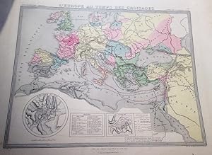
Zustand: ACEPTABLE. Europa en los Tiempos de las Cruzadas. [E. Soulier del.] ; [Revu par Mr. Hase, Membre de lInstitut.] ; Perteneciente al Atlas Élémentaire Simplifié, núm. 28. Formato (cm): 43x53.

