Gesamtpreis (1 Artikel Artikel):
Versandziel:

blunt edmund march george william (12 Ergebnisse)
Direkt zu den wichtigsten Suchergebnissen
Produktart
- Alle Product Types
- Bücher (12)
- Magazine & Zeitschriften
- Comics
- Noten
- Kunst, Grafik & Poster
- Fotografien
- Karten
- Manuskripte & Papierantiquitäten
Zustand
Einband
Weitere Eigenschaften
- Erstausgabe
- Signiert
- Schutzumschlag
- Angebotsfoto (7)
- Keine Print-on-Demand Angebote (10)
Gratisversand
- Versand nach USA gratis
Land des Verkäufers
Verkäuferbewertung
-

Le Piote CĂ tier des Ătats-Unis de de E. Et G. Blunt (Classic Reprint)
Verlag: Forgotten Books, 2018
ISBN 10: 0484985345ISBN 13: 9780484985345
Buch Print-on-Demand
Paperback. Zustand: New. Print on Demand. Excerpt from Le Piote CĂ tier des Ătats-Unis de de E. Et G. Blunt. About the Publisher, Forgotten Books publishes hundreds of thousands of rare and classic books. This book is a reproduction of an important historical work. Forgotten Books uses state-of-the-art technology to digitally reconstruct the work, preserving the original format whilst repairing imperfections present in the aged copy. In rare cases, an imperfection in the original, such as a blemish or missing page, may be replicated in our edition. We do, however, repair the vast majority of imperfections successfully; any imperfections that remain are intentionally left to preserve the state of such historical works. This text has been digitally restored from a historical edition. Some errors may persist, however we consider it worth publishing due to the work's historical value. The digital edition of all books may be viewed on our website before purchase. print-on-demand item.
-
The American Coast Pilot from Passamaquoddy, through the Gulf of Florida together with the courses and distances from Cape Cod and Cape Ann to George's Bank. Corrected and improved.Ninth edition.
Verlag: British Library, Historical Print Editions, 2011
ISBN 10: 1241409013ISBN 13: 9781241409012
Buch
Zustand: New.
-
The American Coast Pilot from Passamaquoddy, Through the Gulf of Florida, Together with the Courses and Distances from Cape Cod and Cape Ann to George's Bank. Corrected and Improved. Ninth Edition.
Verlag: British Library, Historical Print Editions, 2011
ISBN 10: 1241236585ISBN 13: 9781241236588
Buch
Zustand: New.
-
![Bild des Verkäufers für Le pilote cotier des Etats-Unis, de E. et G. Blunt [LeatherBound] zum Verkauf von True World of Books](https://pictures.abebooks.com/inventory/md/md31533431701.jpg)
Le pilote cotier des Etats-Unis, de E. et G. Blunt [LeatherBound]
Erscheinungsdatum: 2023
Buch Print-on-Demand
LeatherBound. Zustand: New. LeatherBound edition. Condition: New. Reprinted from 1854 edition. Leather Binding on Spine and Corners with Golden leaf printing on spine. Bound in genuine leather with Satin ribbon page markers and Spine with raised gilt bands. A perfect gift for your loved ones. NO changes have been made to the original text. This is NOT a retyped or an ocr'd reprint. Illustrations, Index, if any, are included in black and white. Each page is checked manually before printing. As this print on demand book is reprinted from a very old book, there could be some missing or flawed pages, but we always try to make the book as complete as possible. Fold-outs, if any, are not part of the book. If the original book was published in multiple volumes then this reprint is of only one volume, not the whole set. Sewing binding for longer life, where the book block is actually sewn (smythe sewn/section sewn) with thread before binding which results in a more durable type of binding. Pages: 509 Language: French.
-
The American Coast Pilot from Passamaquoddy, through the Gulf of Florida together with the courses and distances from Cape Cod and Cape Ann to George's Bank. Corrected and improved.Ninth edition.
Verlag: British Library, Historical Print Editions 2011-03-25, 2011
ISBN 10: 1241409013ISBN 13: 9781241409012
Buch
Paperback. Zustand: New.
-
The American Coast Pilot from Passamaquoddy, through the Gulf of Florida, together with the courses and distances from Cape Cod and Cape Ann to George s Bank. Corrected and improved. Ninth edition.
Verlag: British Library, Historical Print Editions, 2011
ISBN 10: 1241236585ISBN 13: 9781241236588
Buch
Zustand: New.
-
The American Coast Pilot from Passamaquoddy, through the Gulf of Florida together with the courses and distances from Cape Cod and Cape Ann to George s Bank. Corrected and improved.Ninth edition.
Verlag: British Library, Historical Print Editions, 2011
ISBN 10: 1241409013ISBN 13: 9781241409012
Buch
Zustand: New. KlappentextbTitle:/b The American Coast Pilot . from Passamaquoddy, through the Gulf of Florida . together with the courses and distances from Cape Cod and Cape Ann . to George s Bank . Corrected and improved . Ninth edition.br.
-

Le Pilote Côtier Des États-Unis, De E. Et G. Blunt
Verlag: WENTWORTH PR, 2018
ISBN 10: 0270387889ISBN 13: 9780270387889
Buch
Gebunden. Zustand: New.
-
The American Coast Pilot from Passamaquoddy, through the Gulf of Florida, together with the courses and distances from Cape Cod and Cape Ann to George*s Bank. Corrected and improved. Ninth edition.
Verlag: British Library, Historical Print Editions, 2011
ISBN 10: 1241236585ISBN 13: 9781241236588
Buch
Paperback. Zustand: Like New. Like New. book.
-
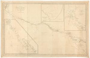
West Coast of North America, from the Gulf of Dulce to San Francisco.
Verlag: New York: E. & G.W. Blunt, 1848., 1848
BLUNT, Edmund March (1770-1862) and George William BLUNT. West Coast of North America, from the Gulf of Dulce to San Francisco. New York: E. & G.W. Blunt, 1848. Single sheet (22 2/8 x 35 2/8 inches). Engraved chart of the western coast of North and Central America from the Gulf of Dulce to San Blas, with 3 insets laid down on blue paper for rolling (old folds). Provenance: with RIBA auction, 6/13/92; from the important cartographical library of Warren Heckrotte, his sale, Rare Cartography, Exploration and Voyages, Part II, December 3, 2015, Lot 99 A detailed and large scale map western coast of North and Central America from the Gulf of Dulce to San Blas, ON THE EVE OF THE CALIFORNIA GOLD RUSH, with three insets of the "Harbour of Monterey", "The Harbour of San Francisco", and Upper and Lower California, showing the coast from San Blas to San Francisco. Published near the end of the Mexican-American War (1845-1848), which gave the U.S. possession of Upper California, and showing the area that would become the state of California in 1850. Warren Heckrotte notes that he could find no direct references to this map, but comments extensively on parallel sources: "Re inset 2: Philo White in his 'Cruize in the Pacific' briefly notes the undertaking of the survey ofMonterey Bay (p 67): 'Capt. Dornin has directed some 5 or 6 officers to employ themselves in taking soundings in this Bay: Their survey will be, of necessity, quite superficial; yet will doubtless be useful, in ascertaining the true depth of water, etc.' Re inset 1: The part of California from San Diego north to Sutters bears a close resemblance to the manuscript map by Price of California, reproduced by W-TW 524. Price has more details, but those that are in Blunt correspond closely to those of Price, with only a few exceptions. The distinctive names of some of the rivers are identical, as well as their course. Price was purser aboard the US ship Cyane which returned to the eastcoast Oct 9, 1848. Wheat states that it must be a copy of an unidentified Mexican original. Another similar map is a manuscript map by Naglee, W-TW 550. He also notes a J.Calvin Smith map of 1847 which has some similar aspects; W-TW 552. This then explains in general way the source of Blunt's map". Blunt was one of "America's first hydrographers. He published some of the first nautical books and charts in the United States. The American Coast Pilot was first printed in 1796. It went through twenty-one editions before being taken over by the federal government in 1867. The American Coast Pilot provided sailing directions from Passamaquoddy, Maine, to the Strait of Florida. It included soundings and bearings of the lighthouses and beacons (such as there were) from rocks, shoals, ledges, etc. The volume also had courses and distances between numerous locations, settings of the currents, and tide tables. The book was extremely popular with ship owners and masters and lives on today as the Coast Pilot published by the National Oceanic and Atmospheric Administration (NOAA). In 1799, he retained Nathaniel Bowditch to update the British publication The New Practical Navigator and adapt it to American needs. The third edition, published in 1802, had been significantly altered from the original and was renamed as the American Practical Navigator. We know it now simply as Bowditch. Few people today are aware that the originator of both publicationsthe Coast Pilot and Bowditchwas Edmund Blunt. He also compiled some of the first detailed surveys of major US east coast ports, from Boston to Charleston. The standards he established in 1796 for accuracy and thoroughness continue today as a worthy legacy to a major, but largely forgotten, figure in American nautical history" (Dennis Bryant, "Edmund M. Blunt: Forgotten Pioneer of Nautical Charting and Publishing in the United States" in Maritime Musings, January 2010).
-
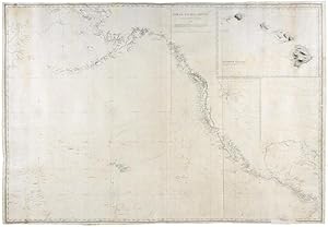
2 sheets, joined (36 4/8 x 53 inches). Engraved chart of the Northern Pacific Ocean and the west coast of North America, with 2 insets, several compass roses, lines of latitude and longitude, and soundings (old folds, creases, short tears occasionally with minor loss, recently laid down on blue paper). Provenance: sold by Benj. Loring & Co. of Boston, with their printed label on the verso; with many ship tracks marked in pencil, 1853 -1856; with Martayan Lan, 5/09; from the important cartographical library of Warren Heckrotte, his sale, Rare Cartography, Exploration and Voyages, Part II, December 3, 2015, Lot 98 A detailed and large-scale chart of the northern Pacific Ocean from Kamchatka to the Atlantic side of Panama, with a large inset of the "Sandwich Islands", ie Hawaiian Islands, in upper right, and a smaller inset "Part of Upper California" just beneath. All major towns and missions along the North American coast are located and named, in the East Bay, Castro and S. Leandro, Rancho of Castro and Rancho Peralta are located, the Sacramento and San Joaquin Rivers are shown, Tule Lakes and the Sierra Nevada. The inset of northern California extends from San Simeon to Bodega Bay and a bit east of Mt. Diablo. The pencilled ship tracks include that for the Brig Oriental, dated 1853, coming from south of the equator turning east then north and west of Hawaii, to San Francisco. However most record the ship Far West, from 1854 to 1856. The position of Fanning Island, now Tabuaeran, has been corrected in manuscript by moving it about 1ş west. Warren Heckrotte notes: "The New York Times "Maritime Intelligence" notes several instances of the Far West arriving in New York City from New Orleans. The Oriental left Maine in 1849 for San Francisco. The Far West was in SF Bay in 1850; see Delgado, To California by Sea. I have a Blunt chart of the west coast from the Gulf of Dulce to San Francisco, 1848. The rendition of the California coast is much different than on this chart - one year makes a difference. The date in the lower margin is 1850. Does this indicate a new issue? References: Burstyn, Harold, At the Sign of the Quadrant. This is a history of the Blunts. It does not provide details of their charts or a listing. At this time of writing their was no compilation of their charts. Among their many publications was Sailing Directions for the West Coast of North America, from Bodega Cape to San Lucas, 1849. A companion to this chart?" Blunt was one of "America's first hydrographers. He published some of the first nautical books and charts in the United States. The American Coast Pilot was first printed in 1796. It went through twenty-one editions before being taken over by the federal government in 1867. The American Coast Pilot provided sailing directions from Passamaquoddy, Maine, to the Strait of Florida. It included soundings and bearings of the lighthouses and beacons (such as there were) from rocks, shoals, ledges, etc. The volume also had courses and distances between numerous locations, settings of the currents, and tide tables. The book was extremely popular with ship owners and masters and lives on today as the Coast Pilot published by the National Oceanic and Atmospheric Administration (NOAA). In 1799, he retained Nathaniel Bowditch to update the British publication The New Practical Navigator and adapt it to American needs. The third edition, published in 1802, had been significantly altered from the original and was renamed as the American Practical Navigator. We know it now simply as Bowditch. Few people today are aware that the originator of both publicationsthe Coast Pilot and Bowditchwas Edmund Blunt. He also compiled some of the first detailed surveys of major US east coast ports, from Boston to Charleston. The standards he established in 1796 for accuracy and thoroughness continue today as a worthy legacy to a major, but largely forgotten, figure in American nautical history" (Dennis Bryant, "Edmund M. Blunt:
-

Chart of the Gulf of Mexico, West Indies, and Spanish Main.
Verlag: New York: E & G.W. Blunt, 1845 [but 1848]., 1848
BLUNT, Edmund March (1770-1862) and George William BLUNT. Chart of the Gulf of Mexico, West Indies, and Spanish Main. E. & G.W. Blunt, 179 Water Street, New York. Entered According to Act of Congress, in the Year 1845, by E & G.W.Blunt in the Clerk's Office of the District Court of the Southern District of New York. 1845. Additions to 1848. Several sheet joined vertically and horizontally (37 x 84 inches). Fine engraved map of the Gulf of Mexico and surrounding coastline (some repairs to margins and verso). With detailed insets of: - A Geometrical Plan of the Principal Harbour [i.e. San Juan] in the Island of Porto Rico Surveyed in 1794 by Don Cosme de Churruca, Captain in the Spanish Navy. W. Hooker, Sc. - Harbour of Matanzas [Cuba]. W. Hooker, Sc. - Rum Key Surveyed in H.M.S. Blossom. - Ragged Islands Anchorage [Bahamas] Surveyed by Commander R. Owen. 1834. - Entrance to the Harbour of Havanna W. Hooker, Sc. - St. Martin's Harbour [i.e. Philipsburg, Saint Martin] surveyd. by Capt. E. Barnet, R.N. 1847. - Bay of Mayaguez, Porto Rico Surveyed by Andrew Scott. 1846. E & G.W. Blunt, Burling Slip, N. York. - Harbour of St. Thomas, [i.e. Charlotte Amalie, V.I.] by Captain L.I. Rhode, Harbour Master. 1822. - Laguna de Terminos Surveyed by Robert Hume. Hooker. 1841. - Atchafalaya and Bayou Teche. by J.D. Boylan. 1841. - The Harbour of Tampico from Actual Survey. 1833. New York, [N.d]. An extremely detailed map of the Gulf coast showing the Texas coast, as surveyed by Commodore E.W. Moore, and the Gulf Mexico from Florida to to Yucatán, from "The French, Spanish, English Admiralty, & U.S. Government Surveys, up to this date", and the expedition of Commodore Matthew C. Perry to 1848. Blunt was one of "America's first hydrographers. He published some of the first nautical books and charts in the United States. The American Coast Pilot was first printed in 1796. It went through twenty-one editions before being taken over by the federal government in 1867. The American Coast Pilot provided sailing directions from Passamaquoddy, Maine, to the Strait of Florida. It included soundings and bearings of the lighthouses and beacons (such as there were) from rocks, shoals, ledges, etc. The volume also had courses and distances between numerous locations, settings of the currents, and tide tables. The book was extremely popular with ship owners and masters and lives on today as the Coast Pilot published by the National Oceanic and Atmospheric Administration (NOAA). In 1799, he retained Nathaniel Bowditch to update the British publication The New Practical Navigator and adapt it to American needs. The third edition, published in 1802, had been significantly altered from the original and was renamed as the American Practical Navigator. We know it now simply as Bowditch. Few people today are aware that the originator of both publicationsthe Coast Pilot and Bowditchwas Edmund Blunt. He also compiled some of the first detailed surveys of major US east coast ports, from Boston to Charleston. The standards he established in 1796 for accuracy and thoroughness continue today as a worthy legacy to a major, but largely forgotten, figure in American nautical history" (Dennis Bryant, "Edmund M. Blunt: Forgotten Pioneer of Nautical Charting and Publishing in the United States" in Maritime Musings, January 2010).