Gesamtpreis (1 Artikel Artikel):
Versandziel:

goldsmith sydney (9 Ergebnisse)
Direkt zu den wichtigsten Suchergebnissen
Produktart
- Alle Produktarten
- Bücher (9)
- Magazine & Zeitschriften
- Comics
- Noten
- Kunst, Grafik & Poster
- Fotografien
- Karten
-
Manuskripte &
Papierantiquitäten
Zustand
Einband
Weitere Eigenschaften
- Erstausgabe
- Signiert
- Schutzumschlag
- Angebotsfoto (1)
- Kein Print-on-Demand
Land des Verkäufers
Verkäuferbewertung
-

Softcover. Zustand: Bon. Ancien livre de bibliothčque. Légčres traces d'usure sur la couverture. Tampon ou marque sur la face intérieure de la couverture. Edition 2020. Ammareal reverse jusqu'ŕ 15% du prix net de cet article ŕ des organisations caritatives. ENGLISH DESCRIPTION Book Condition: Used, Good. Former library book. Slight signs of wear on the cover. Stamp or mark on the inside cover page. Edition 2020. Ammareal gives back up to 15% of this item's net price to charity organizations.
-

Zustand: New.
-
Zustand: VeryGood. signs of little wear on the cover.
-
Zustand: LikeNew. Remainder mark.
-
Zustand: New. .
-
Paperback. Zustand: new. New.
-
Paperback. Zustand: new. New Copy. Customer Service Guaranteed.
-
JADE PHOENIX: THE NEW VOICES IN
Verlag: iUniverse, 2006
ISBN 10: 0595375499ISBN 13: 9780595375493
Buch
Zustand: New. New. In shrink wrap. Looks like an interesting title! 1.05.
-
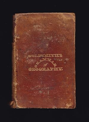
GOLDSMITH'S GRAMMAR OF GEOGRAPHY for the use of schools and young persons with Maps and Engravings
Verlag: Longman, Rees, Orme, Brown and Green, London, 1827
Buch
Hardcover. Zustand: Good. Zustand des Schutzumschlags: No Jacket, as Issued. Sydney Hall (maps engraved and drawn by) (illustrator). New Edition. Circa.1827 (dated by first map). Seven folding maps and full-page copper-engravings: Solar and Lunar Eclipse, The Zodiac, The Seasons, Phases of the Moon, Comparative size of Planets, Mariners compass, Theory of the Tides; Vienna, Dutch, Amsterdam; Constantinople, Turks, Rome: London, French, Paris; Lisbon, Madrid; Dublin, Scotch, Edinburgh; Canton, Chinese, Calcutta; Quebec, Indians, Washington; Artificial Globe and Armillary Globe. ***A new edition corrected and modernized. ***Good in original leather boards. Five gilt bordered compartments to spine. Tail of spine frayed and split. Corners of boards worn and bumped. Boards rubbed. Spine worn with top portion missing. Top inner corners of a few rear pages lightly water splashed. Contemporaneous owner's name, place, date to top of contents page: 'William Green, Market Deeping, April 9th 1878.' Owner's name in ink: Green John Deeping London top front pastedown and: R. P. Green, Ness? Deeping to bottom of end of preface and John Green to pages 62 & 63. On rear pastedown contemporaneously in pencil names and places: William Green Market Deeping, Deeping St James, Walter Milford Green Deeping St James, Robert Pearson Green Bow Church Yard London, Arabella Jessie Green. Vignette to title-page. Missing frontispiece? ***Seven folding maps drawn and copper engraved by Sydney Hall, and published by Longman: The World engraved in 1827; please note that the folding Map of Europe is only half complete, half of the map is torn off (still showing Great Britain, Ireland, France and Spain. Map of British Isles torn and creased to edges with small section torn off top right-hand corner removing the Shetland Islands but not the Orkney Islands; Map of Asia not torn - complete; Map of North America torn along one-third of one foldover but complete; map of South America small tear to lower edge - complete; map of Africa complete - has small tear to lower edge. 191 pages plus one-page of publisher's titles to rear. ***Contents: The Solar System, Geographical Definitions, The Whole Earth: Europe: Sweden and Norway, Denmark, Russia, Prussia, Netherlands, Germany: Saxony, Bavaria, Wurtemberg, Hanover, Austria; Turkey in Europe, Ionian Islands, France, Switzerland, Italy, Spain, Portugal, Great Britain and Ireland: England, Wales, Scotland, Ireland, General Summary of Europe; Asia: Asiatic Turkey, Russia in Asia, Chinese Empire: Chinese Proper, Chinese Tartary, Thibet; Japanese Empire, Birman Empire; Hindoostan, Persia, Tartaria, or Independent Tartary, Arabia, Oriental Archipelago, Australasia, Polynesia, General Summary of Asia; America, North America, United States, British Possession in North America, Native Tribes, West Indies; South America, Spanish Republics, Brazil, Guayana; Africa: Egypt, Abyssinia, Barbary, Sierra Leone, Guinea, Caffraria and Cape of Good Hope, Mozambique and Zanguebar, Ajan and Adel Isles; Summary of Africa; General Facts, worthy of being remembered: Physical Geography: seasons and climates, Winds, Earthquakes, Tides, Saltiness of the Sea, Aurora Borealis, Temperature of the Earth, Varieties of the Human Species, Difference of Language and Nation, Difference of Religion, Civilization in its different degrees, Society and forms of Government; Use of the Globes: Problems of the Terrestrial Globe; Problems of the Celestial Globe; etc. ***Turkey in Europe, once the seat of civilization, learning, and the arts, includes ancient Greece and other countries, formerly the finest in the world, but, owing to the Mahometan religion, to the despotism of the government and to the ignorant policy of the Turks, now the most desolate.' ( p 29). ***An early, 1827 antiquarian edition complete in its original leather boards, of interest to collectors of antiquarian maps, antiquarian children's books, geography and travel titles. A scarce pre-Victorian children's book, with all seven maps albeit half of one map torn off as listed above, but unusual to find in the original binding, unrestored.