Gesamtpreis (1 Artikel Artikel):
Versandziel:

visscher, Hardcover (Mehr als 1.300 Ergebnisse)
Direkt zu den wichtigsten Suchergebnissen
Produktart
- Alle Produktarten
- Bücher (1.388)
- Magazine & Zeitschriften
- Comics
- Noten
- Kunst, Grafik & Poster (5)
- Fotografien
- Karten (5)
-
Manuskripte &
Papierantiquitäten
Zustand
Einband
- alle Einbände
- Hardcover
- Softcover
Weitere Eigenschaften
- Erstausgabe (130)
- Signiert (22)
- Schutzumschlag (125)
- Angebotsfoto (667)
- Kein Print-on-Demand (1.077)
Gratisversand
Land des Verkäufers
Verkäuferbewertung
-
Van Keulen's De Groote Nieuwe Vermeerderde Zee-Atlas ofte Water-Waerld - 183 Originally Hand-colored Maps or Charts
Erscheinungsdatum: 1708
Kunst / Grafik / Poster
Hardcover. Zustand: Fine. This extraordinary and exceedingly rare atlas is from Johannes and Gerard Van Keulen and entitled in full "De Groote Nieuwe Vermeerderde Zee-Atlas ofte Water-Waerld. Vertoonende in zig alle de Zee-Kusten des Aardryks. Bestaande in zeer nette Kaarten, zo platte als wassende Graden: waar in ontdekt zyn alle Baayen, Reeden, Klippen, Droogtens, Dieptens, Anker-plaatzen, en alle Strekkingen en Opdoeningen van Landen: ook haar lengten en Polus hoogten, &c. Dienende tot Opbouwinge en Voortplantinge der Scheepvaart, uit nieuwe Opgevingen van Schippers, Stuurlieden en Liefhebbers der Zeevaart. Te zamen vergaadert en in â t ligt gebragt, door Gerard van Keulen, &c." The work was published in amsterdam by Gerard van Keulen in 1708 (but 1709). --- This was the largest Van Keulen sea atlas ever issued. Keulen atlases of this size are rarely available. The last notable records we see are Sotheby's in 1984 with 160 charts and Christie's in 2019 with 133 charts. --- Johannes van Keulen (1654-1711) was a Dutch publisher. He was said to have produced â the largest and finest marine atlases in Holland.â (Koeman) He received a privelege from the States General of Holland and West Friesland in order to printe maritame atlases and shipping guides. The privilege was to protect his printed material from illegal reproduction. He named his printing firm, In de Gekroonde Lootsman, which grew to be one of the most successful Amsterdam publishing firms. He collaborated with other cartographers including Claes Janszoon Vooght and Johannes van Luyken. --- Keulen's first atlas, entitled "Zee Atlas", contained only 40 charts. By 1695 his atlas would have 160 charts. His son, Gerard, took over publication in 1704 and expanded the atlas to 185 charts by 1709. --- Gerard van Keulen (1678-1727) was a skilled engraver, mathematician, and chart-maker. He was appointed Hydrographer to the Dutch East India Company in 1714. The van Keulen publishing firm operated continuously from 1678 to 1885 with three generations of the family active in the firm. --- The volume is bound in contemporary Dutch calf gilt, covers with a gilt stamped central armillary sphere within an arabesque, spine in compartments with raised bands gilt. --- Present in the atlas: 183 hand-colored engraved plates and charts (nearly all double-page or folding, with the world map credited to Nicolaes Visscher) 14 of which are coastal profiles, Hand-colored engraved allegorical title page or frontispiece dated 1709 (by Aernout Naghtegael after Jan Lukeyn), Folding letterpress title in Dutch dated 1708, Additional title in French dated 1709, 12 pages of Dutch text, 8 pages of French Text, 5 hand-colored allegorical divisional titles dated 1709. --- The contents collates broadly with Koeman Keu 28 (dated 1709 and containing 185 charts), with the following exceptions: the French letterpress title here is dated 1709 rather than 1707; in Part 2 charts (55)+(56) have been joined to form a large folding chart; charts (60) and (61) have been replaced by â Nouvelle carte marine Generale croissant ende-GrĂ s du Canal â ¦ A New General and Gradual increasing Compass Map of the Channel â ¦â ; chart (86) has been replaced with â Paskaert van Cales tot Cadiz â ¦â ; chart (97) has been replaced with â Pascaart van de kust van Portugalâ ; and there is an additional chart after (105) titled â Nieuwe Pascaert vande kust van Maroca en Zanhagaâ ; in Part 3 chart (111) has been updated with â Nieuwe paskaart van tâ opkomender Straat Gibralter â ¦â ; and two pairs of charts have been joined: (126)+(129), and (127)+(128) to form two large folding charts; and in Part 4 (136) has been replaced by â Paskaert waer in de graden der breedde over weder zyden â ¦â . The Dutch letterpress title is dated 1708 and contains the address of Gerard van Keulen, while the general allegorical title and 5 allegorical divisional titles are all dated 1709 and show the address of Johannes van Keulen. A further letterpress.
-
Atlas minor, sive geographia compendiosa qua orbis terrarum per paucas attamen novissimas tabulas ostenditura.
Verlag: Amsterdam: Nicolaes Visscher, [1696 or later]., 1696
Buch
Hardcover. Zustand: Very Good. 2 volumes. Folio (532 x 335 mm). 6 engraved titles, including a general title by Gerard de Lairesse HEIGNTENED IN GOLD and 5 allegorical regional engraved titles, for the Low Countries (Germaniae inferior), by Lairesse, Europe, Asia, Africa, and America, these four from Blaeu's Atlas Major, the last three HEIGHTENED IN GOLD, the first 3 unsigned, the America title signed by the engraver T. Falck, 186 full-sheet or folding engraved maps by Visscher, all with EXCEPTIONALLY FINE HAND-COLOUR BY A MASTER COLOURIST, POSSIBLY A PUPIL OF THE CELEBRATED DIRK JANSZ. VAN SANTEN the maps colored in outline with cartouches, decorative borders, embellishments, and landmarks fully colored, most undated, three maps dated 1696, two dated 1694 and one dated 1656, most double-page, 13 folding (1 1/2 sheets and smaller), the maps variously numbered in ink at upper left, lower or upper right, and/or on versos (the two volumes separately numbered) mounted on guards throughout. Loosely inserted is a full-sheet view-plan of Purmer by I. Leupenius (uncolored). Publisher's blind-stamped dark brown goatskin over pasteboard (rebacked, restoration to corners and board edges, some rubbing). Provenance: Henry Grier Bryant (1859-1932), explorer and geographer, president and benefactor of the Geographical Society of Philadelphia, bookplate. AN EXCEPTIONALLY FINE composite atlas, WITH EXTRAORDINARY LAVISH AND MASTERLY HAND-COLOURING, in the style of the celebrated Dutch colourist Dirk Jansz. Van Santen (1637/38-1708), whose manner is signified by rich and exotic colour combinations, added elements such as flowers to clothing, marbling to masonry, all found here: ". van Santen applied transparent and opaque colours at the same time in both mixed and pure tints. He often painted the whole surface of th map or illustration, transforming the graphic light and dark contrasts into colour. To dark areas representing shadows, clothing pleats or the 'repoussoir', the foreground of a landscape, he applied his characteristic shiny varnish; this had the effect of brightening the colour. He devoted a great deal of attention to skies and horizons, frequently making use of the same colour progression." (Goedings). Atlases and books coloured by van Santen are found in the libraries of the most prominent collectors of the golden age of Dutch cartography ".Bibles and atlases, bound in deluxe bindings by Albert Magnus (1642-1689) and decorated by van Santen were considered gifts worthy of princes. Travellers and poets wrote about this work" (Goedings). This magnificent atlas is of the series of large atlases compiled and sold by the Visscher family of art dealers and cartographers at the end of the seventeenth and early eighteenth centuries. No two of the Visscher atlases seem to have been identical in content, and most contain, like this one, a selection of maps by the Visschers themselves as well as other cartographers. The present particularly extensive atlas, issued without the usual printed or manuscript index, was probably assembled and colored to order for a German or Dutch customer, the first volume being almost entirely devoted to Northern European maps. The general contents are as follows: 1 celestial map by Ludovico Vlasblom after Johannes van Keulen, 3 world maps, consisting of two double-hemisphere maps, by Visscher (Shirley 406) and Carel Allard (Shirley 578), and Jacob Robyn's single hemisphere map on a projection centered on the North Pole (Shirley 582); one map each of the North Pole (Jansson) and South Pole (unsigned, probably Jansson-Mercator); 160 European maps including Scandinavia (12), Germany, including present-day Austria and Switzerland (43), Low Countries (48), Britain (7), France (21), Spain and Portugal (5), Italy (12), Malta (1), and Eastern Europe (i.e, Russia, Livonia, Poland, Prussia, Hungary and Greece, 11); 6 maps of Asia, 4 of Africa, and 10 maps of the Americas. 108 maps are by Nicolaes Visscher; the remainder are by Frederick de Wit (44), Hu.
-

Folio (21 x 13 4/8 inches). Near contemporary manuscript index leaf listing 147maps. Engraved allegorical title-page for "Atlas Maior", fine double-page engraved map of the world "Planisphaerium Terrestre, sive Terrarum Orbis. Amsterdam ca., 1705 by Carol Allard (Shirley 578, a bit creased), and 146 maps, including 7 folding, numbered in a contemporary hand, ALL COLORED IN A CONTEMPORARY HAND (map of Great Britain with chipping to green coloring due to oxidization, map of Hungary torn along fold, some maps trimmed closely, some light browning and staining, some edges a bit frayed). Original Dutch vellum, panelled in blind (lower hinge split at the head and foot of the spine, a bit soiled, lacking two pairs of ties) Provenance: early ink library stamp of the "Historical Association" on the front paste-down. A fine and comprehensive composite atlas, most published by de Wit but with additional maps by Visscher, Allard, Chatelain and Mortier. In addition to the striking world map by Allard with its black background and numerous projections, and found in the "Atlas Major" from about 1705, there are maps of the continents, regional maps of Europe; and unusually high number of maps of Asia (11) Ottens s "Imperium Japonicum .", Amsterdam, dated 1715, and a fine map of the East Indies showing the northern coastline of Australia; 5 maps of Africa; and 11 maps of the Americas, notably including Carel Allard s "Recentissima Novi Orbis sive Americae Septentrionalis et Meridionalis" Amsterdam, ca. 1700; Visscher s "Nova Tabula Geographica Complectens Borealiorem Americae Partem." Amsterdam, ca. 1690 or later; Visscher s "Carte Nouvelle Contenant la Partie d'Amerique la Plus Septentrionale." Amsterdam, ca. 1685 or later; Ottens "Totius Neobelgii Nova et Accuratissima Tabula" Amsterdam, ca. 1708 (Burden 373, state 6); Henry Chatelain s "Carte de la Nouvelle France, ou se Voit le Cours des Grandes Rivieres de S. Laurens & de Mississipi . de la Floride, de la Louisiane, de la Virginie, de la Marie-Lande, de la Pensilvanie, du Nouveau Jersay, de la Nouvelle Yorck . " (no date). De Wit was born in Gouda in 1630 became one of the "most famous engravers of maps of the second half of the 17th-century" (Koeman), his earliest maps issued in 1654. In addition to being geographically correct, de Wit s maps are full of detail and are often decorated with elaborate cartouches. "Frederick de Wit, who was the sole proprietor of the firm, was not just a conveyor of maps but also an innovator in the field of commercial cartography. His maps and in particular his atlas production changed the form in which atlases were consumed in the second half of the seventeenth century. de Wit produced and successfully marketed the first concise reference atlas. de Wit s cartographic production is one of the key factors that joined the early Netherlands period in cartography ca 1550 to ca. 1675, to the latter years of Dutch commercial cartography, and European atlas production in the eighteenth century" (George Carhart).
-
Nuremberg et Amsterdam principalement. Extręme fin XVIIčme - début XIXčme sičcle. Format oblong in-Plano 54x64 cm. Recueil de cartes anciennes rassemblées et reliées au début du XIXčme sičcle. La majorité des cartes (COLOREES !) sont l'oeuvre de Frédéric de Witt d'Amsterdam et de Jean-Baptiste Homann (et ses héritiers) de Nuremberg (soit fin XVIIčme - premičre moitié XVIIIčme sičcle). Des cartes non colorées et plus récentes d'origine française pour la plupart (seconde moitié du XVIIIčme sičcle et dans de rares cas début du XIXčme sičcle) ont été intercalées ŕ la suite de chaque pays ou région. Cet ensemble exceptionnel représente ainsi 193 feuillets in-plano portant une ou plusieurs cartes, plans ou vues. Différentes numérotations ŕ la plume laissent supposer que plusieurs ouvrages différents de moindre envergure ont servi ŕ la constitution de cet ensemble imposant. Celui-ci se présente actuellement dans une reliure utilitaire en demi-parchemin ŕ coins du XIXčme sičcle. Traces d'usage sur la reliure et poussičre sur la tranche des cartes, quelques feuillets légčrement brunis, sinon contenu en bon état général. CONTENU : Europe (Frédéric de Witt) / Espagne et Portugal (Frédéric de Witt) / Portugal (Frédéric de Witt) / carte routičre dépliante d'Espagne et du Portugal (Hubert Jaillot 1793) / France (Frédéric de Witt) / France (Delafosse 1782) / Pays-Bas (Frédéric de Witt) / Belgique (Frédéric de Witt) / Frise (Frédéric de Witt) / Groningue (Frédéric de Witt) / Overyssel (Frédéric de Witt) / Geldre (Frédéric de Witt) / Zutphanice (Frédéric de Witt) / Région d'Utrecht (Frédéric de Witt) / Hollande (Frédéric de Witt) / Sud de la Hollande (Frédéric de Witt) / Région de Delft (Frédéric de Witt) / Région d'Amsterdam (Frédéric de Witt) / Nord de la Hollande (Frédéric de Witt) / Zélande (Frédéric de Witt) / Nord des Pays-Bas (Mr. Janvier 1780) / Sud des Pays-Bas (Mr. Janvier) / Belgique (Frédéric de Witt) / Flandre (Frédéric de Witt) / Artois (Frédéric de Witt) / Brabant (Frédéric de Witt) / Evęché de Cambrais (Frédéric de Witt) / Région de Namur (Frédéric de Witt) / Duché du Luxembourg (Frédéric de Witt) / Limbourg (Frédéric de Witt) / Evęché de Ličge (Frédéric de Witt) / Région de Campen et Bruxelles (Frédéric de Witt) / Westphalie (Frédéric de Witt) / Route des Pays-Bas vers l'Italie / Italie antique (Guillaume de l'Isle 1715) / Italie au temps d'Auguste (Matthieu Seutter) / Italie (De la Marche 1778) / Lombardie occidentale (Robert) / Lombardie orientale (Robert) / Italie, Corse et Sardaigne (Frédéric de Witt) / Cours du Pô (1734) / Piémont et Montferrat en 2 planches (Gabriel Bodenehr) / Région de Nice (vers 1744) / Théâtre de la guerre entre la France et l'Italie / Duché de Milan (Jean-Baptiste Homann) / Parmes et Plaisance (héritiers Homann 1731) / Modčne et Reggio (Matthieu Seutter) / République de Gęnes avec plan et vue de la ville en 1743 (héritiers Homann) / Région du Mont-Blanc (M.A.P.) / Duché de Mantoue (héritiers Homann 1735) / Territoire de Vérone (Jean Jansson) / Plans des opérations de guerre en Italie en 1742 et 1743 (héritiers Homann) / Plans des forts de Fuentčs, du château de Serravalle, des villes de Novarre, Crémone, Tortone, Casale et Pavie (atelier Homann) / Vue du château de Colorno prčs de Parme et du combat du 4 juin 1734 (atelier Homann) / Plan du passage de la Secchia et de la bataille de Guastalla en 1734 (héritiers Homann) / Plans des villes de Côme, Lodi, Picighitone, Crémone, Valence et Alexandrie (Gabriel Bodenehr) / Etats de l'Eglise, Toscane et Corse (Robert) / Corse (de Saint-Angelo) / Latium (héritiers Homann 1745) / Patrimoine de Saint-Pierre (héritiers Homann 1745) / Nord du royaume de Naples (Jaillot 1781) / Sud du royaume de Naples (Jaillot 1781) / Sicile (Frédéric de Witt) / Sicile et Sardaigne (Homann) / Malte (Frédéric de Witt) / Plans des villes de Florence, Pise, Ancone, Rome, Bologne, Sienne, Lucques, Capoue, Naples, Galliupoli, Tarente, Messine, Palerme ( Cornelis Danckerts) / Saint-Empire (Delamarche 1792) / Allemagne vers 1804 (Jean Walchs) / Cercle de la Bavičre en 1796 (Jean Walchs) / Région de Munich (héritiers Homann 1743) / Cercle de Souabe en 1803 (Jean Walchs) / Région d'Ulm (Jean-Baptiste Homann) / Marquisat de Burgow (Matthieu Seutter) / Evęché de Freysingen (Matthieu Seutter) / Archevęché de Salzbourg (Jean-Baptiste Homann) / Tyrol (Gérard Valk) / Suisse (Weiss) / Cours du Rhin (Frédéric de Witt) / Cours du Danube (Gérard Valk) / Hongrie (Frédéric de Witt) / Hongrie et pays voisins jusqu'ŕ Constantinople / Région de Posen en Hongrie (héritiers Homann 1757) / Hongrie et Serbie (2 petites cartes) / Ancienne Pannonie & Illyrie et Transylvanie (2 petites cartes) / Plan et vue de la ville de Temeswar (Matthieu Seutter) / Plan de Belgrade (Gabriel Bodenehr) et fortifications de la ville / Valachie et Bulgarie (2 petites cartes) / Moldavie et Pays slaves (2 petites cartes) / Vallachie et Moldavie (héritiers Homann 1769) / Croatie et Bosnie (2 petites cartes) / Dalmatie et Podolie - Bessarabie (2 petites cartes) / Dalmatie (R. P. Coronelli) / Canal de Cattaro avec les plans des villes et forts de Castelnuovo, Risano et Prevesa (5 petites cartes) / Golfe de Prevesa (4 petites cartes) / Plans d'Urana, Carin, Nadin, Duare, etc. (9 petites vues) / Coron, Calamata, Zarnata, etc. (9 petites vues) / Canal de Corfou, îles de Céphalonie, Zante, etc. (9 petites cartes et vues) / Plan et vue de l'île et ville de Corfou (Matthieu Seutter) / Ville de Corfou et environ (Jean-Baptiste Homann) / Sičge de Corfou en 1716 (Jean-Baptiste Homann) / Achaďe antique et moderne (Jean-Baptiste Homann) / Empire Turque (Jean Lhuilier) / Grčce (Hugo Allardt) / Nord de la Grčce (héritiers Homann) / Pélopončse (héritiers Homann) / Mer Noire et région de Constantinople (T. C. Lotter) / Candie (Crčte) (Frédéric de Witt) / Carte et vue de Candie (N.Visscher) / Candie et îles de la Mer Egée (Jean-Baptiste Homann) / Opérations militaires de la guerre entre Turcs, Hongrois et Po.
-
Atlas minor, sive geographia compendiosa.
Verlag: Amsterdam: Nicolas Visscher [chez la veuve de Nicolas Visscher], [ca 1716]., 1716
Folio (21 3/8 x 13 2/8 inches). Letterpress title-page. Additional allegorical engraved title-page and 101 double-page engraved maps of which 7 are folding, all with exceptionally fine contemporary hand coloring (some light creasing and marginal soiling, lower margin of southern France expertly renewed, lower and right margin of Castile expertly renewed, tear in upper fold of New Castile affecting image and right margin expertly renewed). Contemporary Dutch vellum, each cover decorated in panels with fine central gilt arms of the Admiralty of Rotterdam and four stamped corner pieces containing armillary spheres, all edges gilt (expertly recased); modern tan clamshell case. Provenance: with the arms of the Admiralty of Rotterdam in the center of each cover and with the initials "P.P.P" [Pugno Pro Patria ("I fight for the fatherland")] beneath. A fine atlas from the house of Visscher, who were among the leading producers of maps in Amsterdam in the 17th and 18th centuries. Founded by Nicholas Visscher, whose work is known for the high quality of engraving, exceptionally fine ornament, and accurate geographical information. The maps that relate to America include Carel Allard's (1648-1709) "Planisphaeriam terrestre sive terrarum orbis." [1696], a fine double hemisphere world map surrounded by eight smaller projections depicting the world from various angles, and for smaller circular diagrams, all against a dark cross-hatched background. California is shown as an island and the coastlines of New Zealand and Australia are shown in part; and his two fine Celestial maps. Six further maps depict America: Visscher's "Novis orbis sive Americae", "Nova Tabula Geograpguca complecters. Borealiorem Americae Partem", "Insulae Americanae", Jamaica, Brasil, and Paraguay. "Indiae Orientalis" depicts the northern coastline of Australia. From the distinguished library of the Admiralty of Rotterdam, also known as the Admiralty de Maze, the oldest of the five influential Admiralties of the Dutch Republic at the height of Dutch maritime supremacy. Established in 1574 during the Dutch revolt after the Capture of Brielle) William I of Orange's supporters decided to pool their naval resources at Rotterdam, in the Prinsenhof the former Saint Agnathaklooster, at Botersloot. Although the building was finally demolished in 1884 the arms of the Admiralty with the crossed anchors and an abbreviation of its motto Pugno Pro Patria ("I fight for the fatherland") on the remains of the original gate can be seen in the collection of the Rijksmuseum in Amsterdam. The structure of the five Admiralties (Amsterdam, Rotterdam, Firesland, West-Friesland and Zeeland) was eventually determined and defined in 1597 by the States-General of the Netherlands. Each Admiralty had branches for equipping warships, protecting overseas trade and traffic on the sea and rivers, collecting taxes, and jurisdiction over loot and price setting. The admiralties were dissolved in 1795 with the rise of the Batavian Republic. Catalogued by Kate Hunter.
-
Atlas minor, sive geographia compendiosa qua orbis terrarum per paucas attamen novissimas tabulas Ostenditur
Verlag: Amsterdam: Nicolai Visscher, [ca 1715]., 1715
Folio (21 x 13 4/8 inches). Letterpress title-page with some letters hand-coloured red and green (early marginal repair to lower corner). Engraved allegorical title-page with hand-colour in full (Koeman Vis 12, with early marginal repair to lower corner), fine double-page engraved map of the world "Planisphaerium Terrestre, sive Terrarum Orbis. Amsterdam ca., 1705 by Carol Allard (Shirley 578, a bit creased), and 120 double-page maps and plates with hand-colour in full, including 12 folding (most maps with early repairs to lower corners, only affecting the image on the last 5 maps; all maps with marginal dampstaining, particularly to the lower corners, more pronounced towards the end of the atlas). Contemporary Dutch paneled vellum (lightly soiled, gilt rubbed, endpapers renewed). Provenance: with the early 20th -century bookplate of R & V Andreen on the front paste-down. A fine and comprehensive composite atlas, and one of a series of large atlases compiled and sold by the Visscher family of art dealers and cartographers at the end of the seventeenth and early eighteenth centuries. No two of the Visscher atlases seem to have been identical in content, and most contain, like this one, a selection of maps by the Visschers themselves as well as other cartographers. In this case the majority of the maps are published by Visscher, with additional maps by: Allard of the world, Europe, Africa, the New World, the English channel, and Friesland; Blaeu of Brasil; de Wit; Jansson; Reland, of the Japanese Empire, engraved by B. Ruyter in 1715, and the Persian Empire; Schenk; and Specht. In addition to the striking world map by Allard with its black background and numerous projections, and found in the "Atlas Major" from about 1705, there are maps of the continents, regional maps of Europe, ten maps of Asia, and seven maps related to America: Allard's "Novi orbis, sive Americae septentrionalis et meridionalis", Visscher's "Carte nouvelle contenant la partie d'Amerique la plus septentrionale", "Nova tabula geographica complectens Borealiorem Americae partem", "Insulae Americanae", Jamaica, and "Carte du Paraguary, du Chili, detroit de Magellan"; and Blaeu's map of Brasil. See Koeman Vis 12. Catalogued by Kate Hunter.
-
Atlas minor, sive geographia compendiosa qua orbis terrarum per paucas attamen novissimas tabulas Ostenditura
Verlag: Amsterdam: Nicolaes Visscher, [ca 1689, or later]., 1689
Folio (21 4/8 x 13 inches). Letterpress title-page and Index leaf listing 21 maps. Fine engraved allegorical title-page with original hand-colour in full (Koeman Vis 12), fine double-page engraved double hemisphere map of the world (Shirley 406, 1658), and 28 double-page maps, including two with index panels added to either side, and three folding (some early repairs to verso, and the map of North America torn with extensive loss). Contemporary drab paper boards newly backed with scarlet morocco gilt. The highly attractive world map "Orbis Terrarum Nova Et Accuratissima Tabula" (1658) is "regarded as the master forerunner of a number of highly decorative Dutch world maps. [with] minor variations in the still unknown coastline of North America. The northern part of California (as an island) has been flattened and is now entitled Nova Albion , still further north a small piece of land or an island Anian appears adjacent to a strait leading within striking distance of the west shores of Hudson s Bay. In china, stippling is used for the first time in a general map to denote a desert: this is the extensive Xamo Desertum . just west of the Great Wall of China" (Shirley). The detailed allegorical border depicts dramatic classical scenes representing the rape of Persephone, Zeus being carried across the heavens in an eagle-drawn chariot, Poseidon commanding his entourage, and Demeter receiving the fruits of the Earth. Two smaller spheres fall between the cusp of the larger hemispheres and based on polar projections that of the south pole depicts the southernmost tip of South America. The other maps include many maps of Europe, the continents, and a map of the East Indies showing most of the western and northern coastline of Australia, Britain with additional index panels at either edge, Scotland (corner strengthened on verso), Ireland (ditto), Poland, Sweden and Norway, Denmark, folding map of the Roman Empire, 2 maps of the Rhineland and Moselle, Switzerland, the 17 Provinces of "Germaniae Inferior", Belgium, Belgii Regii, a folding map of Galle and Fancia with index panels at either edge (extensive early repairs to verso), Spain and Portugal, Italy, a folding map of Hungary, a folding map of the Turkish empire, the Greek archipelago, the East Indies showing the northern coastline of Australia, Africa, Barbary, North and South America, South America, North America (which is torn with considerable loss). See Koeman Vis 12. Catalogued by Catalogued by Kate Hunter.
-
An Exceptionally Fine Small Atlas. - Nieut Kaert-Boeck, vande XVII Nederlandse Provincies.
Verlag: Amsterdam: F. de Wit, 1660-1666., 1666
2 works in one volume, folio (20 2/8 x 12 inches). Engraved title-page to "Nieut Kaert-Boeck" (using that of Jacob van Campen's "Afbeelding van't Stadt Huys an Amsterdm" [1661] with de Wit' s present title on an engraved overslip, together 53 double-page engraved mapsheets, all except one hand-colored in outline the cartouches and other embellishments fully hand-colored (first few maps with repaired splits at lower fold), manuscript contents in a contemporary hand, 7 leaves of descriptive text. Contemporary speckled calf, spine gilt in compartments (binding expertly repaired at spine and joints by James Brockman). Provenance: Near contemporary ownership inscription and description of contents of Baron Georg Guldenstiern (1632 -1686), State councillor to Queen Christina of Sweden (1626 - 1689) (ruled 1632-1654), chamberlain to King Charles X Gustavus of Sweden (1622 - 1660) (ruled 1654 - 1660), Chancelor of the Exchequer and of the Admiralty and governor of Stockholm 1678-1682 under King Charles XI (1655 - 1697), (ruled 1660-1697), governor of the provinces of Kronoberg and Uppland from 1657 and 1664 respectively; Christopher Henry Beaumont Pease, Lord Wardington (1924-2005), Library of Important Atlases and Geographies, Sotheby s, 10th October 2006, lot 359. AN EXCEPTIONALLY FINE EXAMPLE of an early small de Wit atlas. Purchased by Baron Georg Guldenstiern, explaining the addition of the regional maps of Uppland and Götaland, which are not normally found in De Wit's small atlas. In two parts: a general world atlas and a regional atlas of the seventeen Dutch provinces. It contains a number of important maps found only in de Wit's early small atlases. The four continental maps are examples of de Wit's first continental maps that he replaced with more modern maps by 1671. The map of Hungary "NOVISSIMA ET EMENDATA DELINEATIO HUNGARIĆ" was originally published by Joannes Meyssens,(Schilder) but with de Wit's imprint it is known of in only one other de Wit atlas held by the map collection of the Amsterdam University Library. Like the map of Hungary the map of Germania by Claes Jansz. Visscher found in this atlas is also replaced by 1671. The World map is de Wit's second, and it is in an earlier state than the one given by Shirley (451), as the page number "1" is in manuscript and is not yet engraved. This is the only copy of this map known without the engraved page number. The atlas can be dated to between 1666 and 1671. Furthermore it can be dated to shortly after 1668, due to the contents of the atlas and several indicators found on the maps within the atlas. The first part of the general atlas has no title page or printed index. This indicates an early atlas as de Wit did not begin to use the familiar allegorical title page with Atlas holding up the heavens until shortly before 1671. The lack of a printed index also indicates a pre 1671 date as the printed indexes that are found in most of his atlases did not appear until ca.1671. The date of after 1666, for the earliest possible date for this atlas, is known as the atlas contains a map of Brabant: "Tabula Ducatus BRABANTIĆ ." dated 1666. Further this portion of the atlas also has the second state of de Wit's title page for his atlas of the seventeen provinces. The title page calls for twenty maps and it has a printed index of twenty maps on the verso. Both the title page and the index help in dating the atlas. De Wit acquired the plate for this title page in 1666 along with a number of plates of Amsterdam from Dancker Danckerts (Shirley 451 and 499). De Wit subsequently had a new title text for his provincial atlas printed that he then pasted over the original Danckerts text on this title page. There are three renditions of the new title block, the first indicating only fourteen maps, the second indicating twenty and the third twenty-five maps. We know that the fourteen map provincial atlas was first advertised by de Wit on the 14th of June 1667, in the "Oprechte Haerlemse C.
-
Atlas minor sive geographia compendiosa in qua orbis terrarum paucis attemen novissimis tabulis ostenditur. Atlas nouveau, contenant toutes les parties du Monde, Ou sont Exactement Remarquées les empires, monarchies, royaumes, etats, republiques, &c. &c. &c. Receuillies des Meilleurs Auteurs
Verlag: Regner & Josue Ottens, Amsterdam, 1720
Zustand: Good. THE CHAMPAGNE-WARDINGTON COPY. Amsterdam: Regner & Josue Ottens, [ca. 1720]. Folio (20 7/8" x 13 1/8", 529mm x 334mm): [pi]1. Title-page printed in red and black. With 53 engravings, all with original hand-color: 44 double-page maps (including a double-hemisphere world map), 4 folding maps, 4 double-page charts and 1 double-page illustrations of types of fortifications. Bound in later diced calf over marbled boards. On the spine, six raised bands. Title gilt to the second panel. Crest and motto ("PAX ET SPES") of Pease gilt to the panels. Marbled end-papers.Repaired in 2023 by Brockman (full report available). Maps numbered in ink in an old hand verso. Manuscript alphabetical index (in French) to the verso of the final sheet, calling for 59 illustrations. Ownership signature of "Geo Champagne" to the title-page and to the index. Wardington bookplate to the rear paste-down.Brothers Reinier (1698-1750) and Josua (1704-1765) Ottens were governors of Amsterdam's guild of booksellers; this gave them unprecedented access to the maps of Europe -- France in particular. The present work (which is sometimes found with an engraved title-page as well) contains maps by Jaillot, de Wit, de l'Isle, de Fer and Visscher inter alia. In the XVIIc and XVIIIc the Dutch were superlative cartographers in their own right, but also freely adapted -- a less generous term might be "pirated" -- the maps of others. The organization of maps is quite traditional: from the double-hemisphere map continue several dozen maps of Europe. Toward the end appear the rest of the world: Asia, Africa and the Americas. The final sheet gathers up a variety of types of star and other fortifications in use historically and around the world. George Champagne (sometimes Champagné; 1751-1828) was descended of a prominent line of French protestant émigrés (Huguenots) to England. He served as Rector of Twickenham from 1802-1818, and from 1802-1828 was Canon of (St. George's Chapel) Windsor, occupying the third stall. Champagne is remembered by the gift of some Ł233 of Old South Sea annuities he made in 1822 to the Dean and Canons of Windsor which was used to set up a fund to buy books or clothes for students of the National School at Windsor. Christopher Henry Beaumont Pease (1924-2005), 2nd Baron Wardington, was a book collector of great renown, building a splendid library at his Oxfordshire home, Wardington Manor. His particular interest was the very finest examples of cartography. His sale (Sotheby's London, 10 October 2006; the present item was lot 362) was a landmark in the field, and its catalogue practically a reference work in its own right.
-
Biblia, dat is: de gantsche H. Schrifture, vervattende alle de canonijcke boecken des Ouden en des Nieuwen Testaments.Amsterdam, widow of Paulus Aertsz. van Ravesteyn, 1660. 3 parts in 1 volume. Large folio (47.5 x 32 cm). With an integral engraved general title-page, 6 double-page engraved maps, including a world map and a plan of Jerusalem, and 336 Bible-illustrations by Claes Jansz. Visscher (after Matthäus Merian?) on 42 numbered single-page plates. The maps and illustrations coloured by an early hand with extensive use of gold. 18th-century black so-called sharkskin over bevelled wooden boards (ca. 1770?), with 8 large silver corner-pieces and 2 large silver clasps with catchplates and anchorplates, all with matching stamped relief decoration, gilt and gauffered edges. The silver furnishings bear Amsterdam city hallmarks with year letter C and master's mark DF. Rebacked with most of the original backstrip mounted on the spine.
Anbieter: Antiquariaat FORUM BV, Houten, Niederlande
Bewertung:

Erstausgabe
[20], 302, [2], 149; 164, [10]; [2], 66 ll.Extra-illustrated large folio edition of the Dutch Statenbijbel (States Bible) with 6 maps and 336 illustrations hand-coloured, the translation officially authorized by the Dutch Reformed Church and published with a privilege from the States General of the Dutch Republic. The 1619 Synod of Dordrecht established a committee to prepare the new translation, and leading Dutch scholars worked on it for nearly twenty years before Paulus Aertsz. van Ravesteyn (ca. 1586-1655) published the first edition in 1637. The 6 maps and the engraved illustrations were produced to be inserted into Van Ravesteyn's folio editions. The series of 336 illustrations by Claes Jansz. Visscher with eight to one leaf, are engraved by Cornelis Danckerts. With some browning, but still generally in good condition and with large margins. The binding has been rebacked, as noted, and the "sharkskin" on the boards has some cracks and wear, but the silver furnishings and gauffered edges are well-preserved. A stunning, large States Bible with 6 maps and 336 illustrations coloured by an early hand with extensive gold.l Poortman, Bijbel en prent I, p. 233 (cf. pp. 147, 151); cf. Darlow & Moule 3315; for the maps: Poortman & Augusteijn 27.1-6; the prints not in Hollstein; Poortman Bijbel en prent; for the zilver furnishings: Voet, Amst. zilversmeden 448-449.
-
Speculum Zelandiae dat is Een Beschryvinge ofte Afbeelding der Steden, Ambachts-Heerlijckheden, [ ]
Verlag: Amsterdam, Nicolas Visscher, (1660)., 1660
Couverture rigide. Zustand: Trčs bon. Complete copy, printed on large paper, in sumptuous contemporary colouring of the baroque atlas of the Netherlands. In the last 60 years, auction records mention only 2 copies of the standard issue, one from the first edition of 1657, the other one from the present edition of 1660. A third copy which was incomplete was sold in 1987. The present compilation contains 36 engravings, printed by groups of 4 on the recto of double folios that illustrate baroque architecture of the Netherlands in the middle of the 17th century. The prints not only depict towns, canals, ports, village scenes, mains monuments, but also precarious housing, return from the market, hunting scenes, sailing, castles, churches, convents, wind mills as well as ornamental gardens, the whole entirely enhanced with warm contemporary colouring. (Hollstein, Schut 32; Hollstein, Publ. Clae Claesz Visscher I, 7) The present copy, printed on large-paper, is the only one recorded from this de luxe edition. In the posterior editions, the Ottens ones for instance, engravings were cut and presented separately, and so printed in a 4to format. The Visscher family is famous in the history of printing Atlases in the Netherlands in the 17th century. Nicolas Visscher I, the editor of the present atlas was born in Amsterdam in 1618. Only son of Claes Jansz Visscher, he got married in 1643. When his father died in 1652, he carried on the activity and settled in the Kalverstraat, in Amsterdam, until his passing in 1679.
-
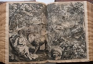
Venationes Ferarum, Avium, Piscium. Pugnae Bestiarorum: & mutuae Bestiarum, Depictae A Joanne Gallaeo : Carmine illustratae a C. Kiliano Dufflaeo. Generoso, prudenti, ac consultissimo viro, D. Henrico ab Osthoorn et Sonnevelt, I. V. Licentiato, cognato suo, Philippus Gallaeus amoris ergo libens merito D. D.
Verlag: Antwerp, J. Galle, [circa 1585]., 1585
Couverture rigide. Zustand: Trčs bon. First issue of the edition printed in Antwerp circa 1585 before the printing on the title of the address "Antverpiae, apud Joannem Gallacum", illustrated with a frontispiece and 104 plates mainly dedicated to hunting numbered from 1 to 104. The hunts represented take place in various continents, with animals as exotic as panthers, leopards, elephants, but also more traditional types of hunts such as hunting with hounds, pigeons, deer. The hunting scenes are also mythological, dragons, aquatic monsters are tracked on land and sea. ?They are signed Joan. Stradanus ivent., Joan. Collaert sculp., Joan. Galle excud. Some plates are engraved by Carol. De Mallery, Cornelius Galle, Theodorus Galle; quite a few do not bear the name of an engraver. All are accompanied by legends in Latin verse (four or two verses depending on the plates).? J. Thiébaud. ?Jan van der Straet, better known under the name of Stradanus, is the author of a set of drawings representing various hunting methods. The project of frontispiece, dedicated to Cosimo I de? Medici, indicates that these drawings, based on his tapestry projects for the decoration of the Villa de Cosimo in Poggio a Caiano and executed at the Arazzia Medicae, were to be engraved at a later date. The first edition dedicated to Cosimo I de? Medici, a group of forty engravings executed by Philippe Galle in 1578, is not entitled, like the smallest previous editions. The first one, a series of four plates with decorative framings known as "Tapestry", was engraved by Herman Jansz. Muller and published by Hieronymus Cock (HolI 512-15) in 1570. Several editions of Aux Quatre Vents followed, each with six plates, edited and perhaps also engraved by Adrien Collaert from 1574 to 1576. The success of its untitled edition of 1578 undoubtedly prompted Philippe Galle to follow it up with a larger edition, 104 plates, intended for the Dutch market, with for the first time a title-page, but unfortunately undated. The authors of these plates, several of which had already previously been used, are probably the brothers Cornelis and Theodor Galle, Adriaen and Hans Collaert, as well as Karel de Mallery. Each plate bears an inscription in popular Latin composed by Cornelis Kiliaan, proofreader at Plantin Editions. These are often inaccurate and it is obvious that they are not based on indications communicated by the artist. Philippe's grandson, Joannes, eventually published other editions and the complete series was reengraved on new plates after 1612 for the Amsterdam editor, Claes Jansz. Visscher who had acquired the rights of the Galle family. An edition even dates from 1634. The edition of the engravings spreading over a period of at least thirty years, the date of execution of these drawings is difficult to establish precisely. It would be possible to suggest that some drawings of this group, comparable in technique and style to a drawing by the same author dated 1556 preserved at the Fitzwilliam Museum in Cambridge, were executed before 1560 (see New York, European Drawings from the Fitzwilliam Museum , 1976-7, p. 58, no.91, rep .; engraved by Karel de Mallery and n ° 23 of the Venationes .). It is more likely, however, that most of these drawings were made after completion of the tapestries from Poggio a Caiano, which were woven around 1568. Jan van der Straet (1523-1605), better known as Stradanus, worked most of his life in Italy as an engraver and designer for tapestry factories. From 1553 to 1571, at the service of Cosimo I de? Medici, he set about creating hunting and fishing representations for tapestries to decorate the palace of Poggio a Caiano. The Venationes commemorate the tapestries executed by Stradanus and showing the traditional hunting methods of the Renaissance. ?Jan van der Straet was born in Bruges, probably in 1523. He learned the basics of his profession in this city before going to Antwerp, in the studio of Pieter Aertsen where he stayed.
-
Atlas minor, sive totius orbis terrarum contracta delinea ex Conatibus
Verlag: Amsterdam: Nicolaes Visscher, ca 1740s, 1740
VISSCHER, Nicolaes II (1649-1702). Atlas minor, sive totius orbis terrarum contracta delinea ex conatibus. Amsterdam: Nicolaes Visscher, ca 1740s. Folio (21 7/8 x 13 inches). Late 18th century manuscript contents leaf listing 34 maps, further annotated in the 20th century. Engraved allegorical title page with exceptionally fine original hand-colour in full (laid down), double-page engraved Historical and Geographical table (1704), double-hemisphere world map (Shirley 578) and 34 double-page maps, including 2 folding, all with exceptional contemporary hand-colour in full (some early repairs to verso). 18th-century half calf, marbled paper boards (worn). PROVENANCE: 18th-century and 20th-century annotations to the contents leaf. An interesting composite atlas, including Allard's lovely world map, maps of the continents and 4 of Russia, maps of China, the East Indies, Ceylon, 4 of Africa, 4 of the Americas, 4 of the British Isles, and 6 of Scandinavia. Carel Allard's (1648-1709) Planispheriam terrestre sive terrarum orbis. [1796], a fine double hemisphere world map surrounded by eight smaller projections depicting the world from various angles, and for smaller circular diagrams, all against a dark cross-hatched background. California is shown as an island and the coastlines of New Zealand and Australia are shown in part. Allard's Recentissima Novi Orbis, sive Americae Septentrionalis et Meridionalis tabula of North and South America. Visscher's Insulae Americanae in Oceano Septentrionali ac Regiones adiacentes, a C. de May usque ad Linem Aequinoctialem Visscher's Nova Tabula Geographica complectens Borealiorem Americae Partem: in qua exacte delineatae sunt Canada sive Nova Francia, Nova Scotia, Nova Anglia, Novum Belgium, Pensylvania, Virginia, Carolina, et Terra Nova. One of a series of mostly large atlases compiled and sold by the Visscher family of art dealers and cartographers at the end of the seventeenth and early eighteenth centuries. No two of the Visscher atlases seem to have been identical in content, and most contain, like this one, a selection of maps by the Visschers themselves as well as other cartographers, in this case including 13 maps by Visscher, 6 by Allard, 2 by Blaeu, 2 by Christopher Browne, i by Overton, 3 by Valk and Schenk, 3 by Mortier, 3 by de Wit and 1 by Oleario.
-
La Passion de Jésus-Christ.
Erscheinungsdatum: 1596
Couverture rigide. Zustand: Trčs bon. S.l., 1596-1598.Suite complčte de 12 planches au burin au format in-4. Bords tendus sur une feuille de montage pour chacune. Réunies dans une reliure de vélin ivoire rigide.Dimensions des pages : 249 x 175 mm.Dimensions des gravures : 197 x 130 mm. --- Splendides épreuves du tirage authentique, avec toutes les particularités indiquées par Bartsch. (A. Bartsch, Le peintre graveur, III, 27-38).F.W.H. Hoolstein, n°21 ŕ 32.Précieux exemplaire du plus grand graveur au burin de l'histoire de la gravure qui a composé ces 12 pičces dans la maničre de Lucas de Leyde, « ce qui lui a parfaitement réussi ». A. Bartsch.« En Hollande, ce sičcle s'achčve en apothéose avec Hendrick Goltzius (1558-1617), virtuose du burin comme l'histoire de la gravure n'en a jamais connu. »« A ses débuts, Goltzius travaille pour J. Cock, Ph. Galle dont il grave le portrait en 1582 puis pour N. et C.I. Visscher, H. Hondius, J. Dankaerts, H. Adolfz et d'autres encore. Il grave ŕ cette époque de beaux portraits originaux dans la tradition anversoise : Mercator en 1576, Ch. Plantin et le célčbre Henri IV. L'italianisme le gagne lui aussi. C'est alors le Portrait de H. Bol, celui de Scaliger, et il adopte définitivement ce style dans La Sainte Famille qui serait, d'ailleurs, une gravure d'interprétation d'aprčs Baroccio. Désireux de montrer sa virtuosité, il grave en 1593-1594 la Vie de la Vierge oů il ne copie, ni ne traduit, mais pastiche intelligemment Raphaël, Baroccio, Parmesan, Bassano, Dürer et Lucas de Leyde en exécutant des compositions que ces maîtres auraient pu concevoir.Ce virtuose, ce roi du burin qui va de tour de force en tour de force a laissé des exemples parfaits avec le Portrait de Frederik Vries de 1597 et les célčbres Porte-enseigne.Ainsi s'achčve le XVIe sičcle en Hollande avec le triomphe du beau métier, du travail maniéré dont le chef de file H. Goltzius aura encore quelque influence au XVIIe sičcle. Par contre, la Flandre cath /// N.p., 1596-1598.Complete suite of 12 chiseled plates in 4to format. Gathered in a stiff ivory vellum binding.Dimensions of the pages: 249 x 175 mm.Dimensions of the engravings: 197 x 130 mm. --- Splendid proofs of the authentic first issue, with all the particularities mentioned by Bartsch. (A. Bartsch, Le peintre graveur, III, 27-38).F.W.H. Hoolstein, n°21 ŕ 32.Precious copy of the greatest chisel engraver in the history of engraving who composed these 12 pieces in the style of Lucas de Leyde, "which perfectly did him good". A. Bartsch."In Holland, this century ends in grand style with Hendrick Goltzius (1558-1617), virtuoso of the chisel as the history of engraving never knew."In his early days, Goltzius works for J. Cock, Ph. Galle, whose portrait he engraves in 1582, then for N. and C.I. Visscher, H. Hondius, J. Dankaerts, H. Adolfz and many others. At that time, he engraves beautiful original portraits in the tradition of Antwerp: Mercator in 1576, Ch. Plantin and the famous Henry IV. The Italianism also overcomes him. It is then the Portrait of H. Bol, the one of Scaliger, and he definitely adopts this style in The Holy Family which would be, by the way, an interpretation engraving after Baroccio. Eager to show his virtuosity, he engraves in 1593-1594 the Life of Virgin Mary where he neither copies nor translates, but intelligently does a pastiche of Raphael, Baroccio, Parmesan, Bassano, Durer and Lucas de Leyde by executing compositions that these masters could have conceived.This virtuoso, this king of chisel, who goes from tour de force to tour de force left perfect examples with the Portrait of Frederik Vries in 1597 and the famous Sign-holders.Thus ends the 16th century in Holland with the triumph of fine technique, of mannered work of which the leader H. Goltzius will still have some influence in the 17th century. On the contrary, the Catholic and prosperous Flanders, penetrated by the Spanish pomp, rejects Bruegel's funniness and, with Rubens.
-
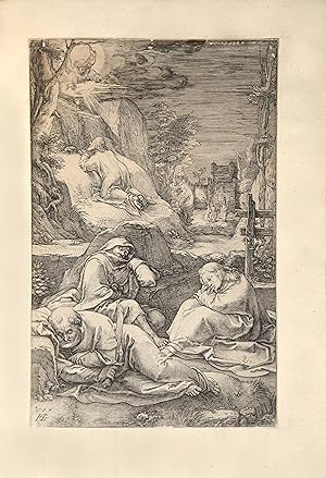
Venationes Ferarum, Avium, Piscium. Pugnae Bestiarorum: & mutuae Bestiarum, Depictae a Ioanne Stradano. Iachten van wilde beesten, vogelen en visschen. [BOUND WITH] Vermis Sericus.
Erstausgabe
S.l. ( Amsterdam ), s.d. ( ca. 1650 - 1660 ), suite of 102 engravings + title page, landscape format : 217 x 300 mm; leaf size :261 x 371 mm. (wide margins !). Bound in (probably) 18th c. full calf, both covers with blindtooled decoration, raised spine with leather title label. Marbled edges. With the printed ex-libris of Maurice de Smet de Naeyer and a small modern ex-libris of Carlo de Poortere ( gold-tooled leather). At the end are bound in the 6 engravings + title of the ''Vermis Sericus''. Two rare and complete suites of engravings bound in a very well preserved binding. The engavings without stains or tears; and with very large margins. [1] A suite of 104 hunting scenes, designed by Stradanus ( 1523 - 1605) was first published in Antwerp in 1578-1580 by Philippe Galle. (See Vanucci 693). The suite was at least twice re-issued by Joannes Galle (1600 - 1676) whereby the Christian name of ''Philip Galle'' is replaced by ''Ioan.''. The Amsterdam publisher Nicolaes Visscher (1618 - 1679) printed at least one of these re-issues. A member of the Visscher family was also involved in the auction sale of the plates from the stock of I.Galle (8 march 1677). In the re-issueing process, for an unknown reason, plates nr. 77 and 84 of the original series got lost or damaged beyond repair. They were replaced by plate 103 and 104 ; the last plates of the original series. Their original plate numbers were erased. So the Visscher series is complete with 102 plates. [2] Bound after the ''Venationes'' is the complete suite : title + 5 plates of '' Vermis Sericus''. (Vanucci 699). The first edition was from 1590 (Philip Galle). Here is a later edition with French text added to the Latin captions. Engraver is L. Renard. Both suites exceptionnally well preserved in an attractive binding.
-
Kort Beskrifning Om ProvincienNyaSwerigeuti America, Som nu förtjden af the Engelske kallas Pensylvania. Af lärde och trowärdige Mäns skrifter och berättelser ihopaletad och sammanskrefwen, samt med ĺthskillige figurer
Verlag: J.H. Werner for Wankijf's widow, Stockholm, 1702
Erstausgabe
Hardcover. Zustand: Very good. First. THE SIEBERT COPY. First edition. Stockholm: J.H. Werner for Wankijf's widow (Tryckt uti Kongl. Boktr. hos Sal. Wankijfs Änkia med egen bekostnad, af J.H. Werner), 1702. Pot quarto (7 3/8" x 5 3/4", 188mm x 146mm). [Full collation available.] With 3 engraved plates and 4 engraved maps, of which two are folding. Bound in contemporary sprinkled calf over wooden boards. On the sine, four raised bands with blind tools in the panels. Blind roll to the edges of the boards. Head and tail-pieces perished, with cracks to the hinges (albeit still sturdy). Some losses to the fore-corners (substantial to the upper rear) and rubbing generally. Mildly and evenly tanned throughout, with the occasional spot of foxing. Repaired fold to the map "Nova Suecia" (tab. V, opp. p. 36). Bottom fore-corner of b4 restored (not affecting the text). Early ink shelf mark ("D-f.21.") to the front paste down, with an obliterated ownership signature adjacent. Graphite bookseller's notes to the recto of the first free end-paper. Presented in a morocco pull-off case with chemise. New Sweden was the earliest colonial settlement in the Delaware River valley (covering parts of present-day Delaware, Pennsylvania, and New Jersey), established in 1638 at Fort Cristina, now Wilmington. The book contains valuable primary historical source material: Campanius Holm(ensis; i.e., from Stockholm), who never traveled to America, based his account on notes left by his grandfather Johannes Campanius, chaplain of the Swedish colony from 1643 to 1648, on verbal accounts by his father, and on the relations of the engineer Peter Mĺrtensson Lindeström (or Linström) and other settlers. His narration of the capture of the territory by the Dutch in 1655 and subsequent life of the Swedes under the Quaker rule of William Penn was also taken from contemporary sources, mainly settlers' correspondence. Parts 3 and 4 of the four parts are devoted to the culture and language of the local Native American tribes; and the Addenda contain a vocabulary of the Delaware language (comparing it to Hebrew), compiled by the author's grandfather. The book contains the earliest continuous meteorological observations in North America, recorded by Johannes Campanius in 1644 and 1645, and an account of the first Finnish colony in North America, at Upland (later Chester, PA), which included the village "Finland." Engraved by Campanius himself, the four maps include a map of the Americas; a small map of the settlement, showing the Delaware River including Philadelphia, after Visscher; another, larger map of the settlement, after Lindeström, titled "New Sweden called today Pensylvania," showing the region claimed by the colony along the Delaware River, and constituting "the first detailed delineation of both banks of the river from Capes May and Henlopen to what is now Trenton" (Quarter of a Millennium, p. 48); and the Eastern seaboard from New France to Virginia and west to Lake Ontario. The engraved illustrations include a view of Niagara Falls and a family of Leni Lenape. Woodcut text illustrations include an archaic full-page map of the Pacific including California, Tartary, and Japan, with the "Terre de Iesso," the Jesuit name for Hokkaido. Dr. Frank T. Siebert (1912-1997) was one of the greatest twentieth-century book-collectors, especially in the field of Americana and more particularly Native American material (his sale, Sotheby's New York, 21 May 1999, the present volume was lot 125). He collected works of the utmost rarity, finest condition and greatest importance. A pathologist by training, his name laces the account-books of the great post-war sellers and collectors on both sides of the Atlantic. The catalogue notes that he acquired the present volume from Lathrop Harper in 1945. Church 803; European Americana 702/108; Field 223; Howes C 84; Pilling 572; Sabin 10202; Streeter, American 25; Streeter sale 947; Vail 291; Wroth Mirror of the Indian 47.
-
Nieuw kaart van den Lande van Utrecht volgens de orde van d Ed: Mog: Heeren Staten [.] doen meten en in kaart brengen, door Bernard du Roy [.] . [Latin title:] Nova tabula dioeceseos Traiectina .
Anbieter: Antiquariaat A. Kok & Zn. B.V., Amsterdam, Niederlande
Bewertung:
Erstausgabe
Large contemporary handcoloured wallmap on 41 connected sheets [total size: c. 170 x 230 cm / map size: c. 120 x 173 cm], engraved by Thomas Doesburgh (fl. 1677-1714), a.o. after ornamental designs by Gerard Hoet (1648-1733), [2nd corr. ed.] pbld by J. Covens & C. Mortier, [Amst., 1743]. (first ed. pbd by Nic. Visscher, Amst., 1696). - Overall browned, sl. waterstained in lower left corner. - Framed.Scarce handcoloured copy of the corrected second state of Bernard de Roy's decorative wallmap of the province of Utrecht, decorated with coat-of-arms on each side and five large profiles of Amersfoort, Rhenen, Utrecht, Wijk by Duurstede & Montford at the bottom. - - Cf. Donkersloot-de Vrij, Topografische kaarten van Nedederland vóór 1750, no. 754 (2de druk); A.H. Sijmons, Nieuwe kaart van den Lande van Utrecht (1973).
-
Van der Borcht Emblemata Sacra 1653
Erscheinungsdatum: 1653
Anbieter: Pictura Prints, Art & Books, Overasselt, Niederlande
Bewertung:
Buch
No binding. Zustand: Good. Emblemata Sacra, e praecipius utriusque . Petro vander Burgio . Johanne Philippi Schabaelie, anno 1653 By Hendrik Jansen Barrefelt (called Hiel). [N.pl.]: Iohanne Phlippi Schabaelie. 4to: Oblong. [25 sheets text], [100 plates] pp. Half leather in slipcase. 19th century half morocco over marbled boards. Gilt titling and five raised bands to the spine. In full leather slipcase with gilt titling to the front. Both text and plates printed to one side of the sheet only.Engraved title and 100 engravings by van der Borcht, text. The rare Barrefeldt illustrated Bible of the religious group: Second House of Love. Originally published by Christopher Plantin in 1581. The spiritual ideas of Heil were expressed in the fine series of engravings designed by Pieter van der Borcht. The plates inspired the remonstrants and liberal protestants of the Dutch Republic like Michel Colin (i.e. Michiel Colijn) who was born in Antwerp and settled in Amsterdam as a publisher and bookseller in 1608. A smaller version of the Bible was first printed by Colin in Dutch in 1613. Colin published several verions of this work,in varying formats and plates. The verses were done by Petrus Sellius of Nijmegen. Later an edition was published by Claes Jansz. Visscher. In 1653 the van der Borcht engravings were incorporated in a print bible by Johanne Philippi Schabaelie: 'Den Grooten Emblemata Sacra', which contained over 300 engravings. But it is known that bibles were also printed to order. This specific edition contains the 100 engravings by van der Borcht, the title page and text pages. The binding is later 19th c. morocco. The book appears to have existed as such by 1700, because an engraved Ex Libris of Petri Ludovici Danes, rector of the University of Leuven is present in front of the book. A note of 'Erven Mr. Ch. Enschedé is present as well which indicates this bible belonged to the Enschedé publisher family as well. Izaak Enschedé published an edition of the Hiel bible containing smaller oblong versions of the plates for his 'Bybelsche Figuren . ' in 1717. Perhaps this specific bible was owned by Izaak Enschedé at the time and used as example for the plates. As a result of the persecution of these religious groups, not only in the Catholic Southern Netherlands but eventually also in the Dutch Republic copies of all editions of Hiel's and Pieter van der Borcht's print-bibles are extremely rare, especially in such fine condition.
-
Antique Book-EMBLEMATA SACRA-BIBLE-Borcht-Barrefelt (Hiel)-1653
Erscheinungsdatum: 1653
Anbieter: Pictura Prints, Art & Books, Overasselt, Niederlande
Bewertung:
Etching/engraving. Illustrations by: Pieter van der Borcht on paper. Size in cm: 4to: 35.5 x 29.5 cm. Size in inch: 4to: 13.99 x 11.62 inch.[N.pl.]: Iohanne Phlippi Schabaelie. 4to: Oblong. [25 sheets text], [100 plates] pp. Half leather in slipcase. 19th century half morocco over marbled boards. Gilt titling and five raised bands to the spine. In full leather slipcase with gilt titling to the front. Both text and plates printed to one side of the sheet only. Antique Book, titled: 'Emblemata Sacra, e praecipius utriusque . Petro vander Burgio . Johanne Philippi Schabaelie, anno 1653', by Hendrik Jansen Barrefelt (called Hiel).', by: Hendrik Jansen Barrefelt. Engraved title and 100 engravings by van der Borcht, text. The rare Barrefeldt illustrated Bible of the religious group: Second House of Love. Originally published by Christopher Plantin in 1581. The spiritual ideas of Heil were expressed in the fine series of engravings designed by Pieter van der Borcht. The plates inspired the remonstrants and liberal protestants of the Dutch Republic like Michel Colin (i.e. Michiel Colijn) who was born in Antwerp and settled in Amsterdam as a publisher and bookseller in 1608. A smaller version of the Bible was first printed by Colin in Dutch in 1613. Colin published several verions of this work,in varying formats and plates. The verses were done by Petrus Sellius of Nijmegen. Later an edition was published by Claes Jansz. Visscher. In 1653 the van der Borcht engravings were incorporated in a print bible by Johanne Philippi Schabaelie: 'Den Grooten Emblemata Sacra', which contained over 300 engravings. But it is known that bibles were also printed to order. This specific edition contains the 100 engravings by van der Borcht, the title page and text pages. The binding is later 19th c. morocco. The book appears to have existed as such by 1700, because an engraved Ex Libris of Petri Ludovici Danes, rector of the University of Leuven is present in front of the book. A note of 'Erven Mr. Ch. EnschedĂ is present as well which indicates this bible belonged to the EnschedĂ publisher family as well. Izaak EnschedĂ published an edition of the Hiel bible containing smaller oblong versions of the plates for his 'Bybelsche Figuren . ' in 1717. Perhaps this specific bible was owned by Izaak EnschedĂ at the time and used as example for the plates. As a result of the persecution of these religious groups, not only in the Catholic Southern Netherlands but eventually also in the Dutch Republic copies of all editions of Hiel's and Pieter van der Borcht's print-bibles are extremely rare, especially in such fine condition.Artists and Engravers: Author(s): Hendrik Jansen Barrefelt. Barrefelt, Hendrik Jansen van (Barneveld, ca. 1520 - ca. 1594, Cologne). The orginal House of Love was founded by Hendrik Niclaes (?-c.1580) and sought for salvation in private spirituality. Around 1573 one of oldest followers Hendrik Jansen Barrevelt split off. His group with followers as Christoffel Plantijn and his friends was called 'The Second House of Love'. Barrefelt considered himself a prophet and styled himself Hiel. Illustrated by: Borcht, Pieter van der (The Elder) (Mechelen, c. 1540 - 1608, Antwerp). Flanders. Active period: 1564-ca. 1600. Etcher/Engraver/Lithographer.Condition: Very good, given age. The edges of the slipcase a little rubbed. Title page detached. Board edges minimally rubbed. Leather on the front outer hinge cracked, hinge still strong. Some scattered foxing, mainly in the text sheet margins. A restored tear in the top right margin of plate 75 (not affecting image).Lower right corner of plate 43 restored.Keywords: ANTIQUE BOOK-EMBLEMATA SACRA-BIBLE-BORCHT-BARREFELT (HIEL)(PCO) ZL6-01.
-
Antique Book-EMBLEMATA SACRA-BIBLE-Borcht-Barrefelt (Hiel)-1653
Erscheinungsdatum: 1653
Anbieter: Pictura Prints, Art & Books, Overasselt, Niederlande
Bewertung:
Etching/engraving. Illustrations by: Pieter van der Borcht on paper. Size in cm: 4to: 35.5 x 29.5 cm. Size in inch: 4to: 13.99 x 11.62 inch.[N.pl.]: Iohanne Phlippi Schabaelie. 4to: Oblong. [25 sheets text], [100 plates] pp. Half leather in slipcase. 19th century half morocco over marbled boards. Gilt titling and five raised bands to the spine. In full leather slipcase with gilt titling to the front. Both text and plates printed to one side of the sheet only. Antique Book, titled: 'Emblemata Sacra, e praecipius utriusque . Petro vander Burgio . Johanne Philippi Schabaelie, anno 1653', by Hendrik Jansen Barrefelt (called Hiel).', by: Hendrik Jansen Barrefelt. Engraved title and 100 engravings by van der Borcht, text. The rare Barrefeldt illustrated Bible of the religious group: Second House of Love. Originally published by Christopher Plantin in 1581. The spiritual ideas of Heil were expressed in the fine series of engravings designed by Pieter van der Borcht. The plates inspired the remonstrants and liberal protestants of the Dutch Republic like Michel Colin (i.e. Michiel Colijn) who was born in Antwerp and settled in Amsterdam as a publisher and bookseller in 1608. A smaller version of the Bible was first printed by Colin in Dutch in 1613. Colin published several verions of this work,in varying formats and plates. The verses were done by Petrus Sellius of Nijmegen. Later an edition was published by Claes Jansz. Visscher. In 1653 the van der Borcht engravings were incorporated in a print bible by Johanne Philippi Schabaelie: 'Den Grooten Emblemata Sacra', which contained over 300 engravings. But it is known that bibles were also printed to order. This specific edition contains the 100 engravings by van der Borcht, the title page and text pages. The binding is later 19th c. morocco. The book appears to have existed as such by 1700, because an engraved Ex Libris of Petri Ludovici Danes, rector of the University of Leuven is present in front of the book. A note of 'Erven Mr. Ch. EnschedĂ is present as well which indicates this bible belonged to the EnschedĂ publisher family as well. Izaak EnschedĂ published an edition of the Hiel bible containing smaller oblong versions of the plates for his 'Bybelsche Figuren . ' in 1717. Perhaps this specific bible was owned by Izaak EnschedĂ at the time and used as example for the plates. As a result of the persecution of these religious groups, not only in the Catholic Southern Netherlands but eventually also in the Dutch Republic copies of all editions of Hiel's and Pieter van der Borcht's print-bibles are extremely rare, especially in such fine condition.Artists and Engravers: Author(s): Hendrik Jansen Barrefelt. Barrefelt, Hendrik Jansen van (Barneveld, ca. 1520 - ca. 1594, Cologne). The orginal House of Love was founded by Hendrik Niclaes (?-c.1580) and sought for salvation in private spirituality. Around 1573 one of oldest followers Hendrik Jansen Barrevelt split off. His group with followers as Christoffel Plantijn and his friends was called 'The Second House of Love'. Barrefelt considered himself a prophet and styled himself Hiel. Illustrated by: Borcht, Pieter van der (The Elder) (Mechelen, c. 1540 - 1608, Antwerp). Flanders. Active period: 1564-ca. 1600. Etcher/Engraver/Lithographer. SHIPPING DISCLAIMER: We offer a standard shipment fee for any international destination (shipment by registered mail through our local postal service) of 15 euro for packages up to 1 kg. For heavier items our cost is often higher causing a surcharge up to 8 euro per kg. We will contact you to arrange for this surcharge.Condition: Very good, given age. The edges of the slipcase a little rubbed. Title page detached. Board edges minimally rubbed. Leather on the front outer hinge cracked, hinge still strong. Some scattered foxing, mainly in the text sheet margins. A restored tear in the top right margin of plate 75 (not affecting image).Lower right corner of plat.
-
Venationes Ferarum, Avium, Piscium. Pugnae Bestiarorum: & mutae Bestiarum, depictae a Ioanne Stradano: Editae per Nicolaum Visscher cum previlegio ordinum Hollandiae et West-Frisiae. Iachten van Wilde Beesten, Vogelen en Visschen, Midtsgaders Stryden van Menschen tegens Beesten, en Beesten tegens malkander.
Anbieter: Antiquariaat Junk, Amsterdam, Niederlande
Bewertung:
Erstausgabe
(Londen c. 1817). Oblong 4to (255 x 360mm). With fine hand-coloured engraved frontispiece and 102 beautifully hand-coloured engraved plates. (Together with:) STRADADUS, J. Vermis Sericus. (London c. 1817). 4to. (255 x 360mm). With fine hand-coloured frontispiece and 5 beautifully hand-coloured engraved plates. Contemporary green half morocco, richly gilt ornamented spine. This late issue of which only a small number were made is probably the most beautifully coloured issue of one of the most attractive huntingbooks ever published. The first edition was published 1578 by P. Galle in Antwerp. "Stradanus, or as he was originally named Jan van der Straat (1523-1605), was born in Bruges, but did most of his work in Italy. He was principally a designer of cartoons for tapestries, and there are very few of his pictures in existence. From 1553-1571 he was employed by the Duke Cosimo de' Medici in Florence, who commissioned him to make a number of designs for tapestries, representing fowling, fishing and hunting scenes, for the adornment of twenty rooms in the Palace of Reggio-a-Cajano. The present set of 'Venationes' was engraved from these beautiful and original compositions" (Schwerdt II, p. 228). The fine plates were engraved by I. Collaert, Cornelius Galle and others. "After pl. 102 is included 'Vermis Sericus', a series including an engraved frontispiece containing 4 vignettes illustrating the development of the silkworm from the month of May to August, and 5 other plates"(Schwerdt). The colouring of this copy is outstanding. On the verso of a few plates small paper restoration at the lower margin. A fine copy.
-
Piscium Vivae Icones inventae ab Adriano Collardo et Excusae.
Erscheinungsdatum: 1630
Couverture rigide. Zustand: Trčs bon. [Amsterdam], Nic. Jos. Visscher, 1634. Titre et 19 planches numerotées de 2 ŕ 20.Premičre édition donnée ŕ Amsterdam en 1634, complčte de ses 20 planches de poissons, et seconde édition générale différente de la premičre imprimée ŕ Anvers vers 1610. Nissen, Zoologische, p. 98.II-Bruyn, Nicolaes de. Libellus varia genera piscium complectens Pictoribus, sculptoribus, caelatoribus, aurifabris etc. mire utilis et necessarius. Nicolaes de Bruyn inventor, Claes J. Visscher, vers 1630.Antwerpen um 1550 ? 1656 Rotterdam (Th.-B.)In-4 de 1 titre frontispice et 12 estampes de poissons et batraciens numérotées de 2 ŕ 13. Premičre planche piquée, ptes. déchirures restaurées en marge des pl. 3, 4, 11 et 12.Premičre édition décrite par Nissen, Zoologische, p. 69.III- Collaert, Adriaen. Avium Vivae et artificiosissimae Delineationes.Amstelodami, impressae apud Nicolaum Visscher, Anno 1659.In-4 oblong, 1 titre frontispice et 23 estampes d'oiseaux numérotées 2 ŕ 24. Pte. rest. En marge des pl. 4, 10, 15 et 24 ; pl. 6, 11 et 18 piquées.IV- Wenzel Hollar, Henri Le Roy / Weyen, Herman. 6 estampes de multiples oiseaux.V- Wenzel Hollar, Henri Le Roy / Weyen, Herman. Muscarum Scarabeorum Vermiung Varie Figure & Formae omnes primo ad vivum coloribus depictae & ex Collectionne Arundeliam.A Paris, rue St Jacques, 1651.Oblong in-4 de 6 estampes de multiples papillons, insectes, scarabées, chenilles, sauterelles etc. y compris le titre (Nissen, Zoologische, 206).VI- Wenceslas Hollar. Animalium, ferarum & Bestiarum, Florum, Fructuum, Muscarum, Vermiumq: Icones variae, omnes ad vivum delineatae, per Wenceflaum Hollar, & In lucem editae a Petro Stent, Londini, A° 1663.A New and perfect Book, of Beasts, Flowers Fruits, butterflies, & other Vermines Exactly drawne after v° life & naturall by W. Hollar. Printed and are to be sould, by Iohn Onertonat the White Horse : without New-Gate, London, A° 1674.Titre et 11 superbes estampes de fleurs et d'animaux gravée /// [Amsterdam], Nic. Jos. Visscher, 1634. Title and 19 plates numbered from 2 to 20.First edition given in Amsterdam in 1634, complete with its 20 fish plates, and second general edition different from the first printed in Antwerp around 1610. Nissen, Zoologische, p. 98.II-Bruyn, Nicolaes de. Libellus varia genera piscium complectens Pictoribus, sculptoribus, caelatoribus, aurifabris etc. mire utilis et necessarius. Nicolaes de Bruyn inventor, Claes J. Visscher, ca. 1630.Antwerpen um 1550 - 1656 Rotterdam (Th.-B.)4to with 1 frontispiece and 12 prints of fishes and amphibians numbered from 2 to 13. First plate spotted, small tears restored in the margin of pl. 3, 4, 11 and 12.First edition described by Nissen, Zoologische, p. 69.III- Collaert, Adriaen. Avium Vivae et artificiosissimae Delineationes.Amstelodami, impressae apud Nicolaum Visscher, Anno 1659.Oblong 4to, 1 frontispiece and 23 bird prints numbered 2 to 24. Small rest. in the margin of pl. 4, 10, 15 and 24; pl. 6, 11 and 18 spotted.IV- Wenzel Hollar, Henri Le Roy / Weyen, Herman. 6 prints of multiple birds.V- Wenzel Hollar, Henri Le Roy / Weyen, Herman. Muscarum Scarabeorum Vermiung Varie Figure & Formae omnes primo ad vivum coloribus depictae & ex Collectionne Arundeliam.Paris, rue St Jacques, 1651.Oblong 4to of 6 prints of multiple butterflies, insects, beetles, caterpillars, grasshoppers etc. including the title (Nissen, Zoologische, 206).VI- Wenceslas Hollar. Animalium, ferarum & Bestiarum, Florum, Fructuum, Muscarum, Vermiumq: Icones variae, omnes ad vivum delineatae, per Wenceflaum Hollar, & In lucem editae a Petro Stent, Londini, A° 1663.A New and perfect Book, of Beasts, Flowers Fruits, butterflies, & other Vermines Exactly drawne after v° life & naturall by W. Hollar. Printed and are to be sould, by Iohn Onertonat the White Horse : without New-Gate, London, A° 1674.Title and 11 superb prints of flowers and animals engraved in 1662 and 1663 followed by 4 landscape prints by Hollar and Chauve.
-
Hardcover. Zustand: Near fine. First. First edition. Vißcher, C[laes] J[anszoon]. Americć nova descriptio. [Amsterdam: Visscher, 1649.] Oblong octavo (5 5/8" x 7 1/8", 142mm x 182mm): binder's blank, engraved pictorial title-page, 25 engraved plates, binder's blank. Bound in modern calf. On the boards, a double gilt fillet border. On the spine, four raised bands with gilt rolls. Panels gilt. Title gilt to red morocco. Gilt roll to the edges of the boards, continuing to the inside dentelle. Marbled end-papers. Damp-stain to the fore-edge. Else fine. The origins of the present item go as far back as 1597, the conception of the Caert-Thresoor: a treasury of maps of the world printed in a much smaller format, intended for consumption by those who could not afford the grand folio atlases that so dominated the Dutch Golden Age of mapmaking. The initiator of this project is sometimes described as (Claes Janszoon) Visscher, and sometimes as Barent Langenes; there is scholarly disagreement. The plates were enormously popular, constantly updated as new explorations refined and adjusted earlier maps, and used not only in atlases but in other publications. It is often noted that this is a collection of maps with text added, and not the other way. Visscher augmented the Caert-Thresoor in 1649 as the Tabularum Geographicum Contractarum Libri Quator Denuň Recogniti, and it is from this that the present item comes. Visscher took the 175 Caert-Thresoor maps and added another 73, updating several as well. The parts of the world were split into eight books (the four books in the title must refer to the four continental divisions), a-h (Europe: a-e, Asia: f, Africa: g, America: h); the present comprises the plates of book h. Of the complete set, Van de Krogt finds only seven copies, and even portions such as the present item -- which must have been common -- are surpassingly rare. Five of the maps are newly-made for the present edition (the numbers in parentheses are of the overall work): h.6 (233) Havana portus, h.9 (236) Divi Ioannis de porto Ricco divite portĹ , h.10 (237) S. Margareta, h.12 (239) Promontor Paria and h.13 (240) Pontaraya. All but the last were engraved by Benjamin Wright. Burden 113.3 calls our map h.2 (Terra Nova) "the first accurate map devoted to Newfoundland." Koeman III.Vis 4=Lan 15; Shirley BL T.LAN-1h; Van der Krogt/Koeman IIIA.341:54.
-
Sammelband mit 66 meist doppelblattgroßen Landkarten bzw. Tafeln verschiedenster Atlanten des 18. Jahrhunderts.
Verlag: (Ohne Ort und Drucker, um 1780)., 1780
Anbieter: Matthaeus Truppe Antiquariat, Graz, Österreich
Bewertung:
Buch Erstausgabe
66 altkolorierte meist doppelblattgr. Kupferstichkarten bzw. Kupfertafeln. Privat zusammengestellter Atlas mit 64 Kupferstichkarten und 2 Kupfertafeln von Kartographen des 18. Jahrhunderts. Unter den Karten und Tafeln sind 29 von Johann Baptist Homann bzw. seinen Erben, 27 von Matthäus (Matthias) Seutter, 3 von Tobias Conrad Lotter, 4 von Nicolaes Visscher, 2 von Gerad Valck und 1 von Johann Jakob Lidl. Unter den Karten sind eine Weltkarte und 4 Erdteilkarten, Karten der deutschen, schweizerischen und österreichischen Ländern, von Frankreich, Italien, Spanien und Portugal, den Niederlanden und von Belgien, den Britischen Inseln, Skandinavien, Russland, dem Balkan, dem Osmanischen Reich sowie zwei Karten von Südamerika. Die beiden Tafeln (von Seutter) mit den Flaggen der sefahrenden Nationen sowie der Tabelle der Entfernungen zwischen den deutschen Städten. - Vorderer Innendeckel mit montiertem alten hs. Kartenverzeichnis. Einige Karten mit Randeinrissen bzw. Bugeinrissen. Teils etw. knitterfaltig, teils einige Läsuren. Etw. gebräunt und teils fleckig. - Eine Auftellung der Karten senden wir auf Wunsch zu. *** *** Copyright: Matthaeus TRUPPE Buchhandlung & Antiquariat - Stubenberggasse 7 - A-8010 Graz - ++43 (0)316 - 829552 *** *** Sprache: Deutsch Gewicht in Gramm: 0 Gr.-Fol. HLdr. der Zeit mit modernen Marmorpapierbezügen (Rücken mit kl. Wurmgängen, etw. beschabt und bestoßen).
-
Castella et Praetoria Nobilium Brabantiae et coenobia celebriora ad vivum delineata. [Castles, manor houses, monasteries and churches of Brabant]. First edition.
Verlag: Antwerp, H. Thieullier, 1694
Kunst / Grafik / Poster Erstausgabe
Zustand: Good. Folio. Contemorary calf, gilt spine on raised bands, restored. 39.5 x 26.5 cm. [4 with frontisp.]-viii pp., 107 pl. of which some double-paged or folding (marg. tear pl. Genap and Carloo, pl. Rixensart part. missing, pl. "Vue et perspective de la maison et jardin du vicomte de la Vuere et Duysberg" printed on pl. Thielen).OCLC 902323684.First edition of the famous extensive work on the castles and manor houses, and principal monasteries and abbeys in the province of Brabant by Jacques Le Roy (1633-1719). This copy has the usual 83 full-page, double or folding plates depicting 143 views of monuments or castles, each with the coat of arms of the owners. It also comprises the often recurring 21 plates with Visscher's map of Brabant and panoramic views and plans of Antwerp, Brussels, Leuven and 's-Hertogenbosch., it also includes: several plates by Wenceslaus Hollar (Pennington nos. 824, 850, 886, 894) incl. Antwerp Cathedral, Groenendael Abbey; Rothendael Abbey, Tongerloo; Antverpien turris ecclesiae cathedralis. Engraved by Gillis Hendricx. - 2. Le chateau de l'anciene famille de Spangen en Hollande. - 3. Conventus FF. Minorum S. Francisci Capucinorum extractus Bruxellis. In addition this copy has the frontispiece after Abraham van Diepenbeke, the "schema metallorum" for the identification of the coat of arms. Plates are engraved by Jacobus Harrewijn, Henri Cause, Gaspar Bouttats and others after Lucas Vosterman, de Cröes, G. de Bruyn, A. Santvoort, R. Whitehand. Ref. BB III:842-847.
-
De Zegepraalende Vecht, vertoonende verscheidene Gesichten va Lustplaatsen, Heeren Huysen en Dorpen; beginnende van Uitrecht en met Muyden besluytende.
Verlag: t'Aamsterdam: Nicolaus Visscher, 1719., 1719
3 works in one volume. Folio (14 4/8 x 9 2/8 inches). Additional engraved title-page by A. van der Laan after A. de Lairesse, fine engraved map of the river Vecht showing stately homes from Utrecht to Myden, 100 fine engraved vignettes of stately homes and grounds on 51 leaves by Daniel Stoopendaal. Original speckled calf, the spine in eight compartments with seven raised bands, red morocco lettering-piece in the second, the others decorated with fine gilt tools (extremities a bit rubbed). [BOUND WITH]: BROUERIUS van NIDEK, Matthaeus (1677-1743). Het Zegenpralend Kennemerland. Te Amsterdam: Andries en Hendrik de Leth, [1730]. Folio. 2 additional engraved title-pages, fine folding engraved map of Kennemerland, 102 fine engraved vignettes on 50 leaves. RADEMAKER, Abraham (1675-1735). Alle de voornaamste Gesigten van de Wydberoemde Steeden Alkmaar, Delft en Dordregt, Geleegen in de Provintie van Holland. Te Amsterdam: Leonardus Schenk, 1736. 67 fine engraved vignettes on 34 leaves. All three first editions, second issue of "De Zegepraalende Vecht " with four extra plates depicting the house of Driemond. Together these three works provide a comprehensive view of Dutch architecture at the end of the golden age of the empire. The detailed engravings are of stately homes, parks, and towns. Best known as a landscape artist, Le Bruyn travelled widely from a young age to Vienna, on to Rome then to Smyrna, Constantinople, Egypt, Jerusalem, Syria, Lebanon, and Turkey. Everywhere he went Le Bruyn depicted the scenes around him, he was especially interested in places of antiquity or historic interest, and his are the first images of the interior of a pyramids and Jerusalem to be widely available to a Westerners. "I want to offer accurate pictures of those cities, towns, and buildings that I have visited," he wrote, "and without recklessness I can claim to have done something that no one has done before" (reported by the New York Society Library). After an eight-years in Venice, Le Bruyn returned to The Hague in 1693 to publish his first book, "Reizen.door de vermaardste Deelen van Klein Asia." Delft, 1698. Catalogued by Kate Hunter.
-
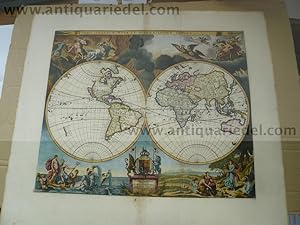
Hardcover. Zustand: very good. Orbis Terrarum Nova Et Accuratissima Tabula, 1680, Moses Pitt Orbis Terrarum Nova Et Accuratissima Tabula. Auctore Ioanne a Loon. Moses Pitt London / 1680 A fine example of Moses Pitt's double hemisphere map of the world. Pitt and his partner acquired the plates from Blaeu's Grand Atlas and set out to issue and even larger Atlas in London. However, after 4 volumes, they landed in Debtor's prison and the atlas was never completed. The map offered here is based upon Visscher's World map of 1658 (Shirley 406) and Van Loon's rare Zee Atlas, first issued in 1661. Size of the sheet: 60 x 67 cm., printed area: 44 x 53 cm., the map is printed on thick paper, wide margins, only little brownish centerfold, fine hand coloured.
-
Hollstein 108-125 first state of 2; Franken 72-89. Set of 18 engravings by and after Jan van de Velde: one titlepage and 17 portraits, each with a 4-line verse at the bottom. Each print mounted, with care and only along the edges, onto 19th cent. paper. Decorated full leather binding, signed Riviere & Son. Very good copy with very good quality prints. B0910.
-
VILLA // PAMPHILIA // EIVSQVE // PALATIVM, // CVM SVIS PROSPECTIBVS, // STATVAE, FONTES, VIVARIA, // THEATRA, AREOLAE, PLANTARVM, // VIARVMQVE ORDINES, // Cvm eivsdem Villae absolvta Delineatione. // [Rossi?s printer?s device] // ROMAE. // Formis Io. Iacobi de Rubeis apud Templum S. Mariae de Pace. // CVM PRIVILEGIO S. PONTIFICIS. // SVPERIORVM PERMISSV.
Verlag: Formis Io. Iacobi de Rubei, apud templum S. Mariae de Pace. Undated [c.1650-latest c.1690, most probably c.1660] [c.1675-1677]., Rome/Romae, 1650
Anbieter: Alexandre Antique Prints, Maps & Books, Toronto, ON, Kanada
Bewertung:

Edition : First and only edition. Italic and Roman type. Tex, Contemporary panelled full burgundy morocco, double-gilt filleted; spine with six (6) raised bands, gilt lettered title on two with remaining compartments gilt ornamented; all edges gilt; contemporary endpapers with watermark of a fleur-de-lis within two concentric circles. Wide margin paper., An architectural plate book depicting statues, and fountains displayed in Villa Pamphili, an important 16th-17th century Roman villa, designed by the painter Giovanni Francesco Grimaldi (1606 - 1680) and Alessandro Algardi (1598 - 1654), followed by the construction of the garden layout; ?1652-1657. The publication of the present work printed by G.G. de Rossi, [possibly c.1675-1677] , was commissioned by Pamphili?s son and heir, Giambattista, with the engraver Dominique Barričre documenting the statues placed both in cornices of the villa and the gardens, and with further plates included, such as some by Giovanni Battista Falda's ?Le fontane di Roma? (fountains of Rome), plus general views of the villa and its gardens. Giovanni Battista Falda (c.1643 ? 1678 Rome) was an Italian architect, engraver and artist. He is known for his engravings of both contemporary and antique buildings and structures of Rome. Falda studied and worked under Bernini; his draughtsmanship drew G. G. de Rossi?s attention. He became well-known for his ?Le fontane di Roma? (Fountains in Rome) and ?Palazzi di Roma? (Palaces of Rome) particularly popular with visitors to Rome. Giovanni Giacomo de Rossi, Italian engraver and printer, active in Rome during the second half of the 17th century. His father, Giuseppe de Rossi (1570-1639), was the founder of the most important and active printing press of the 17th century in Rome. The press started in 1633, it was then passed to Giovanni Giacomo and his brother Giandomenico; and later to Lorenzo Filippo. In 1738 it became the ?Calcografia Camerale?, from 1870-1945 the ?Regia Calcografica?; today it is known as the ?Calcografia Nazionale? Here are conserved, amongst many others, the plates of Giambattista Piranesi (1720-1778). Giovanni Giacomo de Rossi, the most involved of all family members who ran the press, from 1638-1691, took the company to its height of success. He printed etchings for artists including Giovanni Benedetto Castiglione (1609-1665), Pietro Testa (1612-1650) and Giovan. Francesco Grimaldi (1606?1680). Barričre (c.1622?1678) was a French painter and engraver. Barričre was born at Marseilles in about 1622. He spent most of his career in Rome, where he engraved a considerable number of plates, after Claude and other landscape painters, as well as other subjects. They are neatly etched in the manner of Stefano della Bella. He died in Rome in 1678. , Size : Folio (434x312mm)., Fine illustrations of the famous Villa Pamphili, the most important architectural constructions of Baroque Rome, with its Italian garden and the fine collection of antiquities. Illustrated dedication with head- & tail-vignettes, and a large rubricated initial; plus a total of 82 full page and double page oblong folding copper-engraved plates., References : Woodfall, G.; British Museum: Catalogue of Maps, Prints, Drawings Etc. Forming the Geographical and Topographical Collection, vol. II, p. 146 (1829). Rossetti 4827. Cicognara 3911. Berlin Katalog 3491. Kissner 394. Vinciana 4360. Giorgetta F. Hortus libro Lacks folding double-page plan of the Villa Pamphilia and the first of 5 folding plates ?Primus? Otherwise, a very good example, plates are crisp and clean.
-
THE HOLY BIBLE Containing the Old and New Testament. Newly translated out of the Originall tongues and with former translations diligently compared and revised by his Majesties speciall command., (Visscher plates).
Verlag: Amsterdam. Stephen Swart. 1672, 1672
Anbieter: Charles Russell, ABA, ILAB, est 1978, Cirencester, Vereinigtes Königreich
Verbandsmitglied: ABA ILAB PBFA
Bewertung:
Buch
Small folio 15 1/2 x 12 inches - bound in period calf over wooden boards with brass corner pieces, very worn. A TOTAL OF 5 MAPS, ONE PLAN OF JERUSALEM AND 116 DOUBLE PAGE PLATES by Visscher after Bloemaert, d'Hondecoeter, de Vos, Rubens, van Heemskerck, de Brun, de Bruyn, van Winghe etc. Old Testament - engraved title with a cartouche of London, 4 maps and a view of Jesrusalem (the World map torn with loss beyond repair) and 60 double page plates. New Testament - one map and 56 double page plates. WITH THE FOLLOWING PROBLEMS- 2 damaged beyond repair, 12 plates split in the fold but repairable, 9 plates trimmed with slight loss of text not the image and other minor marginal splits. A WORKING OR BREAKING COPY of this magnificent Bible. Some plates with ornamental borders and 'before letters'. Many plates with extraordinary medieval mystical architectural backgrounds. These plates were published in several issues of the Bible both in Dutch and English- Ogilby Bible and Visscher Bible. Some of the most beautiful Bible prints produced in the seventeenth century. These Bibles are found with various plate counts and illustrations. Sold as a defective copy.
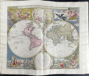
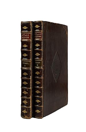

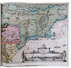
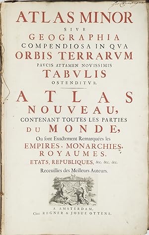
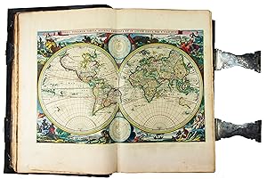
![Bild des Verkäufers für Speculum Zelandiae dat is Een Beschryvinge ofte Afbeelding der Steden, Ambachts-Heerlijckheden, [ ] zum Verkauf von Librairie Camille Sourget](https://pictures.abebooks.com/inventory/md/md31169727584.jpg)


![Bild des Verkäufers für Castella et Praetoria Nobilium Brabantiae et coenobia celebriora ad vivum delineata. [Castles, manor houses, monasteries and churches of Brabant]. First edition. zum Verkauf von Wittenborn Art Books](https://pictures.abebooks.com/inventory/md/md30780656455.jpg)