
Gesamtpreis (1 Artikel Artikel):
Versandziel:

charte nordamerica entworfen gezeichnet reichard von nordamerika (1 Ergebnisse)
Direkt zu den wichtigsten Suchergebnissen
Produktart
- Alle Produktarten
- Bücher (1)
- Magazine & Zeitschriften
- Comics
- Noten
- Kunst, Grafik & Poster
- Fotografien
- Karten
-
Manuskripte &
Papierantiquitäten
Zustand
- Alle
- Neu
- Antiquarisch/Gebraucht
Einband
- alle Einbände
- Hardcover
- Softcover
Weitere Eigenschaften
- Erstausgabe
- Signiert
- Schutzumschlag
- Angebotsfoto
- Kein Print-on-Demand
Land des Verkäufers
Verkäuferbewertung
-
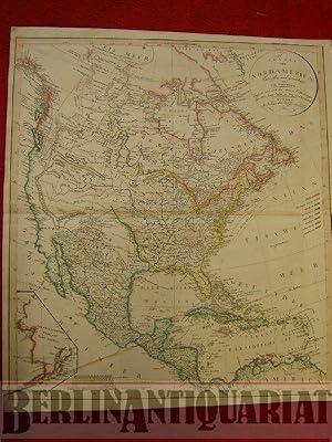
Charte von Nordamerica. Entworfen und gezeichnet von C. G. Reichard. Ergänzt und nach den neuern Entdeckungen der Hrn. Lewis, Clarke u. Pike vervollständigt.
Verlag: Geographisches Institut, Weimar, 1813
Anbieter: BerlinAntiquariat, Karl-Heinz Than, Berlin, Deutschland
Bewertung:

Kupferstich, grenz- und flächenkoloriert. Zweimal gefaltet. Dekoratives Blatt in gutem Zustand. Am rechten oberen Kartenrand winzige Einstichstellen. Nur leicht fleckig, vor allem am Rand und auf der Rückseite. [ENGLISH] Copper engraving. Hand colored in outline and wash. Folded twice. Map is decorative and in good condition. On the right upper frame of the map tiny punctures. Only slightly stained, mainly on the frame and on the back of the map. Maßstabslegenden für geographische Meilen, Spanische oder Castil. Meilen sowie Englische Meilen. Siehe Foto.