![Pacific Stars and Stripes. Map of the War.: [KOREAN WAR MAP].](https://pictures.abebooks.com/inventory/31783332324.jpg)
Pacific Stars and Stripes. Map of the War.
[KOREAN WAR MAP].
Verlag: Geographic Branch, G-2, GHQ, FEC. March1952, 1952
Gebraucht
Softcover
Verk�ufer
Asia Bookroom ANZAAB/ILAB, Canberra, ACT, Australien
Verk�uferbewertung 5 von 5 Sternen
![]()
Heritage Bookseller
AbeBooks-Mitglied seit 1996
Beschreibung
Beschreibung:
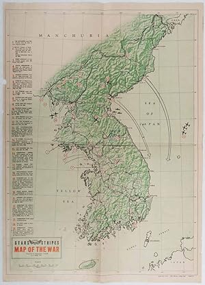
Folding map printed in green, black and red. Few minor chips at edges, title written in ink on reverse, but overall very good. A map of Korean War zone produced by the US military (geographic section) and pub;ished in the magazine "Stars and Stripes" in March 1952. The map marks the main cities and uses numbers and inset text to mark the sites of key actions in Korean War. The number 1, for example, is attached to the 38th parallel, and is accompanied by text reading "NK invaders cross 38th parallel, June 25, 1950, at nine separate points". No. 4 marks the Pusan Perimeter on September 14, 1950 "scene of depsperate stand by UN against NK forces - Gen. Walker orders 'stand or die'". No. 23 marks "POW camps in North Korea" and no. 25 - "UN POW camp at Koje-Do Island". A facinating visual representation of the war from the US point of view. Bestandsnummer des Verk�ufers 177939
Bibliografische Details
Titel: Pacific Stars and Stripes. Map of the War.
Verlag: Geographic Branch, G-2, GHQ, FEC. March1952
Erscheinungsdatum: 1952
Einband: Softcover
Beste Suchergebnisse bei AbeBooks

Foto des Verk�ufers
Pacific Stars and Stripes Map of the War.
Verlag:
Stars and Stripes., [Washington, D.C.]., 1953
Gebraucht
Anbieter: Asia Bookroom ANZAAB/ILAB, Canberra, ACT, Australien
Verk�uferbewertung 5 von 5 Sternen
![]()
78 x 63cm. Edges trifle worn with few small closed tears, mended on reverse, overall a very good copy of a scarce map printed in Japan. A map of the Korean Peninsula marking 25 notable engagements dating from the outbreak of hostilities in June 1950 until June 1952. The map is encircled by two UN flags, the national flags of twenty-two nations supporting UN Command either militarily or through medical support, as well as the insignia of combatant American units. Bestandsnummer des Verk�ufers 177316
Anzahl: 1 verf�gbar