
Gesamtpreis (1 Artikel Artikel):
Versandziel:

charles smith edit (37 Ergebnisse)
Direkt zu den wichtigsten Suchergebnissen
Suchfilter
Produktart
- Alle Product Types
- Bücher (37)
- Magazine & Zeitschriften (Keine weiteren Ergebnisse entsprechen dieser Verfeinerung)
- Comics (Keine weiteren Ergebnisse entsprechen dieser Verfeinerung)
- Noten (Keine weiteren Ergebnisse entsprechen dieser Verfeinerung)
- Kunst, Grafik & Poster (Keine weiteren Ergebnisse entsprechen dieser Verfeinerung)
- Fotografien (Keine weiteren Ergebnisse entsprechen dieser Verfeinerung)
- Karten (Keine weiteren Ergebnisse entsprechen dieser Verfeinerung)
- Manuskripte & Papierantiquitäten (Keine weiteren Ergebnisse entsprechen dieser Verfeinerung)
Zustand Mehr dazu
- Neu (Keine weiteren Ergebnisse entsprechen dieser Verfeinerung)
- Wie Neu, Sehr Gut oder Gut Bis Sehr Gut (Keine weiteren Ergebnisse entsprechen dieser Verfeinerung)
- Gut oder Befriedigend (4)
- Ausreichend oder Schlecht (Keine weiteren Ergebnisse entsprechen dieser Verfeinerung)
- Wie beschrieben (33)
Einband
Weitere Eigenschaften
Sprache (2)
Gratisversand
- Kostenloser Versand nach USA (Keine weiteren Ergebnisse entsprechen dieser Verfeinerung)
Land des Verkäufers
Verkäuferbewertung
-

U.S. Marines in the Korean War
Erscheinungsdatum: 2007
Anbieter: T. Cadman WW2 Books, Carmichael, CA, USA
Verkäuferbewertung 5 von 5 Sternen

Zustand: good. USMC (Washington, DC), 2007, no edit stated, 741 pp, photos, maps, good with rubbing to pictorial hardcover, no jacket as issued,
-

Advances in Physical Metallurgy a Collection of Invited Papers Presented to Mark the 70th Birthday Year of Professor Sir Alan Cottrell
Sprache: Englisch
Verlag: The Institute Of Metals, London, 1990
ISBN 10: 0901462853 ISBN 13: 9780901462855
Anbieter: Webbooks, Wigtown, Wigtown, Vereinigtes Königreich
Verbandsmitglied: PBFA
Verkäuferbewertung 5 von 5 Sternen
Erstausgabe
EUR 14,27
EUR 34,64 Versand
Versand von Vereinigtes Königreich nach USAAnzahl: 1 verfügbar
In den WarenkorbHard Cover. Zustand: Very Good. Zustand des Schutzumschlags: Very Good. First Edition. Clean bright tight copy. Previous owner's name and date on front free end paper. 326495.
-
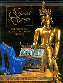
A Grand Design: the Art of the Victoria and Albert Museum.
Verlag: New York: Harry N. Abrams., 1997
Anbieter: Wittenborn Art Books, San Francisco, CA, USA
Verkäuferbewertung 5 von 5 Sternen
Zustand: Good. 4to. 431 pp. Near Fine. Soft Cover. Illustrated paper wraps. Color and B&W plates throughout. ISBN: 0912298707 9780912298702.Heavy volume, additional shipping fees may apply.
-
Clinical Surgery Head and Neck
Verlag: Butterworth, London, 1965
Anbieter: Webbooks, Wigtown, Wigtown, Vereinigtes Königreich
Verbandsmitglied: PBFA
Verkäuferbewertung 5 von 5 Sternen
Erstausgabe
EUR 38,06
EUR 34,64 Versand
Versand von Vereinigtes Königreich nach USAAnzahl: 1 verfügbar
In den WarenkorbHard Cover. Zustand: Very Good. Zustand des Schutzumschlags: Very Good. First Edition. Clean bright tight copy. Glassine dust wrapper. This is a heavy book and we will request extra postage if ordered from outside the UK. Previous owner's name on front free end paper. C00003941.
-

Egypt
Verlag: Egitto
Anbieter: Sergio Trippini, Gavirate, VA, Italien
Verkäuferbewertung 5 von 5 Sternen
Signiert
Carta geografica, in coloritura coeva, riguardante il corso del Nilo e parte del Sinai. Inserita nell'opera "Smith's New General Atlas Containing Distinct Maps Of all the Principal Empires, Kingdoms, & States Throughout the World arranged according to the General Treaty signed in Congress at Vienna June 1815 - London, Printed for C. Smith, Mapseller extraordinary, To His Majesty. N° 172 Strand with additions 1822 to 1824". Edizione non menzionata dal Phillips.
-

The Prussian dominions with the Kingdom of Hanover arrangred according to the teatry of Vienna June 1815
Verlag: Prussia impero
Anbieter: Sergio Trippini, Gavirate, VA, Italien
Verkäuferbewertung 5 von 5 Sternen
Signiert
Carta geografica, in coloritura coeva, riguardante l'impero prussiano dopo il trattato di Vienna del 1815. Inserita nell'opera "Smith's New General Atlas Containing Distinct Maps Of all the Principal Empires, Kingdoms, & States Throughout the World arranged according to the General Treaty signed in Congress at Vienna June 1815 - London, Printed for C. Smith, Mapseller extraordinary, To His Majesty. N° 172 Strand with additions 1822 to 1824". Edizione non menzionata dal Phillips. Autore: Smith Charles edit. & Gardner sculp. Luogo: Prussia impero. Anno: 1820. Tecnica: incisione in rame. Dimensioni: 274x483 mm.
-

Denmark
Verlag: Danimarca
Anbieter: Sergio Trippini, Gavirate, VA, Italien
Verkäuferbewertung 5 von 5 Sternen
Signiert
Carta geografica, in coloritura coeva, riguardante la Danimarka. Inserita nell'opera "Smith's New General Atlas Containing Distinct Maps Of all the Principal Empires, Kingdoms, & States Throughout the World arranged according to the General Treaty signed in Congress at Vienna June 1815 - London, Printed for C. Smith, Mapseller extraordinary, To His Majesty. N° 172 Strand with additions 1822 to 1824". Edizione non menzionata dal Phillips.
-

France according to the treaty of Paris in 1814 & 15
Verlag: Francia
Anbieter: Sergio Trippini, Gavirate, VA, Italien
Verkäuferbewertung 5 von 5 Sternen
Signiert
Carta geografica, in coloritura coeva, riguardante la Francia dopo gli accordi di Parigi del 1814 e 15. Inserita nell'opera "Smith's New General Atlas Containing Distinct Maps Of all the Principal Empires, Kingdoms, & States Throughout the World arranged according to the General Treaty signed in Congress at Vienna June 1815 - London, Printed for C. Smith, Mapseller extraordinary, To His Majesty. N° 172 Strand with additions 1822 to 1824". Edizione non menzionata dal Phillips.
-

Spain & Portugal
Verlag: Spagna - Portogallo
Anbieter: Sergio Trippini, Gavirate, VA, Italien
Verkäuferbewertung 5 von 5 Sternen
Signiert
Carta geografica, in coloritura coeva, riguardante la Spagna, inserita nell'opera "Smith's New General Atlas Containing Distinct Maps Of all the Principal Empires, Kingdoms, & States Throughout the World arranged according to the General Treaty signed in Congress at Vienna June 1815 - London, Printed for C. Smith, Mapseller extraordinary, To His Majesty. N° 172 Strand with additions 1822 to 1824". Edizione non menzionata dal Phillips.
-

France in Provinces
Verlag: Francia
Anbieter: Sergio Trippini, Gavirate, VA, Italien
Verkäuferbewertung 5 von 5 Sternen
Signiert
Carta geografica, in coloritura coeva, riguardante la Francia con la suddivisione delle provincie. Inserita nell'opera "Smith's New General Atlas Containing Distinct Maps Of all the Principal Empires, Kingdoms, & States Throughout the World arranged according to the General Treaty signed in Congress at Vienna June 1815 - London, Printed for C. Smith, Mapseller extraordinary, To His Majesty. N° 172 Strand with additions 1822 to 1824". Edizione non menzionata dal Phillips.
-

Holland
Verlag: Paesi Bassi
Anbieter: Sergio Trippini, Gavirate, VA, Italien
Verkäuferbewertung 5 von 5 Sternen
Signiert
Carta geografica, in coloritura coeva, riguardante i Paesi Bassi. Inserita nell'opera "Smith's New General Atlas Containing Distinct Maps Of all the Principal Empires, Kingdoms, & States Throughout the World arranged according to the General Treaty signed in Congress at Vienna June 1815 - London, Printed for C. Smith, Mapseller extraordinary, To His Majesty. N° 172 Strand with additions 1822 to 1824". Edizione non menzionata dal Phillips.
-

Portugal
Verlag: Portogallo
Anbieter: Sergio Trippini, Gavirate, VA, Italien
Verkäuferbewertung 5 von 5 Sternen
Signiert
Carta geografica, in coloritura coeva, riguardante il Portogallo. Inserita nell'opera "Smith's New General Atlas Containing Distinct Maps Of all the Principal Empires, Kingdoms, & States Throughout the World arranged according to the General Treaty signed in Congress at Vienna June 1815 - London, Printed for C. Smith, Mapseller extraordinary, To His Majesty. N° 172 Strand with additions 1822 to 1824". Edizione non menzionata dal Phillips.
-
Enland and Wales
Verlag: Inghilterra - Galles
Anbieter: Sergio Trippini, Gavirate, VA, Italien
Verkäuferbewertung 5 von 5 Sternen
Signiert
Carta geografica, in coloritura coeva, riguardante l'Inghilterra e il Galles. Inserita nell'opera "Smith's New General Atlas Containing Distinct Maps Of all the Principal Empires, Kingdoms, & States Throughout the World arranged according to the General Treaty signed in Congress at Vienna June 1815 - London, Printed for C. Smith, Mapseller extraordinary, To His Majesty. N° 172 Strand with additions 1822 to 1824". Edizione non menzionata dal Phillips.
-
Scotland
Verlag: Scozia
Anbieter: Sergio Trippini, Gavirate, VA, Italien
Verkäuferbewertung 5 von 5 Sternen
Signiert
Carta geografica, in coloritura coeva, riguardante la Scozia. Inserita nell'opera "Smith's New General Atlas Containing Distinct Maps Of all the Principal Empires, Kingdoms, & States Throughout the World arranged according to the General Treaty signed in Congress at Vienna June 1815 - London, Printed for C. Smith, Mapseller extraordinary, To His Majesty. N° 172 Strand with additions 1822 to 1824". Edizione non menzionata dal Phillips.
-
Sweden and Norway
Verlag: Scandinavia
Anbieter: Sergio Trippini, Gavirate, VA, Italien
Verkäuferbewertung 5 von 5 Sternen
Signiert
Carta geografica, in coloritura coeva, riguardante Norvegia, Svezia, Finlandia e Danimarca. Inserita nell'opera "Smith's New General Atlas Containing Distinct Maps Of all the Principal Empires, Kingdoms, & States Throughout the World arranged according to the General Treaty signed in Congress at Vienna June 1815 - London, Printed for C. Smith, Mapseller extraordinary, To His Majesty. N° 172 Strand with additions 1822 to 1824". Edizione non menzionata dal Phillips.
-
Ireland
Verlag: Irlanda
Anbieter: Sergio Trippini, Gavirate, VA, Italien
Verkäuferbewertung 5 von 5 Sternen
Signiert
Carta geografica, in coloritura coeva, riguardante l'Irlanda. Inserita nell'opera "Smith's New General Atlas Containing Distinct Maps Of all the Principal Empires, Kingdoms, & States Throughout the World arranged according to the General Treaty signed in Congress at Vienna June 1815 - London, Printed for C. Smith, Mapseller extraordinary, To His Majesty. N° 172 Strand with additions 1822 to 1824". Edizione non menzionata dal Phillips.
-
Persia
Verlag: Iran
Anbieter: Sergio Trippini, Gavirate, VA, Italien
Verkäuferbewertung 5 von 5 Sternen
Signiert
Carta geografica, in coloritura coeva, riguardante la Persia. Inserita nell'opera "Smith's New General Atlas Containing Distinct Maps Of all the Principal Empires, Kingdoms, & States Throughout the World arranged according to the General Treaty signed in Congress at Vienna June 1815 - London, Printed for C. Smith, Mapseller extraordinary, To His Majesty. N° 172 Strand with additions 1822 to 1824". Edizione non menzionata dal Phillips.
-
Central Asia
Verlag: Asia centrale
Anbieter: Sergio Trippini, Gavirate, VA, Italien
Verkäuferbewertung 5 von 5 Sternen
Signiert
Carta geografica, in coloritura coeva, riguardante l'Asia centrale. Inserita nell'opera "Smith's New General Atlas Containing Distinct Maps Of all the Principal Empires, Kingdoms, & States Throughout the World arranged according to the General Treaty signed in Congress at Vienna June 1815 - London, Printed for C. Smith, Mapseller extraordinary, To His Majesty. N° 172 Strand with additions 1822 to 1824". Edizione non menzionata dal Phillips.
-
Africa
Verlag: Africa
Anbieter: Sergio Trippini, Gavirate, VA, Italien
Verkäuferbewertung 5 von 5 Sternen
Signiert
Carta geografica, in coloritura coeva, riguardante il continente africano. Inserita nell'opera "Smith's New General Atlas Containing Distinct Maps Of all the Principal Empires, Kingdoms, & States Throughout the World arranged according to the General Treaty signed in Congress at Vienna June 1815 - London, Printed for C. Smith, Mapseller extraordinary, To His Majesty. N° 172 Strand with additions 1822 to 1824". Edizione non menzionata dal Phillips.
-
Belgium and Holland or the United Netherlands, 1815
Verlag: Paesi Bassi - Belgio
Anbieter: Sergio Trippini, Gavirate, VA, Italien
Verkäuferbewertung 5 von 5 Sternen
Signiert
Carta geografica, in coloritura coeva, riguardante i Paesi Bassi, Belgio e Lussemburgo. Inserita nell'opera "Smith's New General Atlas Containing Distinct Maps Of all the Principal Empires, Kingdoms, & States Throughout the World arranged according to the General Treaty signed in Congress at Vienna June 1815 - London, Printed for C. Smith, Mapseller extraordinary, To His Majesty. N° 172 Strand with additions 1822 to 1824". Edizione non menzionata dal Phillips.
-
Europe
Verlag: Europa
Anbieter: Sergio Trippini, Gavirate, VA, Italien
Verkäuferbewertung 5 von 5 Sternen
Signiert
Carta geografica, antica ed originale in coloritura coeva, riguardante l'Europa. Inserita nell'opera "Smith's New General Atlas Containing Distinct Maps Of all the Principal Empires, Kingdoms, & States Throughout the World arranged according to the General Treaty signed in Congress at Vienna June 1815 - London, Printed for C. Smith, Mapseller extraordinary, To His Majesty. N° 172 Strand with additions 1822 to 1824". Edizione non menzionata dal Phillips. Autore: Smith Charles edit. & B. Smith sculp. Luogo: Europa. Anno: 1820. Tecnica: incisione in rame. Dimensioni: 262x350 mm.
-
Greece
Verlag: Grecia
Anbieter: Sergio Trippini, Gavirate, VA, Italien
Verkäuferbewertung 5 von 5 Sternen
Signiert
Carta geografica, in coloritura coeva, riguardante la Grecia e parte della Turchia asiaticainserita nell'opera "Smith's New General Atlas Containing Distinct Maps Of all the Principal Empires, Kingdoms, & States Throughout the World arranged according to the General Treaty signed in Congress at Vienna June 1815 - London, Printed for C. Smith, Mapseller extraordinary, To His Majesty. N° 172 Strand with additions 1822 to 1824". Edizione non menzionata dal Phillips.
-
Turkey in Asia
Verlag: Turchia asiatica
Anbieter: Sergio Trippini, Gavirate, VA, Italien
Verkäuferbewertung 5 von 5 Sternen
Signiert
Carta geografica, in coloritura coeva, riguardante l'Asia minore, inserita nell'opera "Smith's New General Atlas Containing Distinct Maps Of all the Principal Empires, Kingdoms, & States Throughout the World arranged according to the General Treaty signed in Congress at Vienna June 1815 - London, Printed for C. Smith, Mapseller extraordinary, To His Majesty. N° 172 Strand with additions 1822 to 1824". Edizione non menzionata dal Phillips.
-
Peru. Chili and Buenos Ayres
Verlag: Perů - Cile - Bolivia - Argentina
Anbieter: Sergio Trippini, Gavirate, VA, Italien
Verkäuferbewertung 5 von 5 Sternen
Signiert
Carta geografica, in coloritura coeva, riguardante il Perů, il Cile, parte della Bolivia, Paraguay, Uruguay e Argentina. Inserita nell'opera "Smith's New General Atlas Containing Distinct Maps Of all the Principal Empires, Kingdoms, & States Throughout the World arranged according to the General Treaty signed in Congress at Vienna June 1815 - London, Printed for C. Smith, Mapseller extraordinary, To His Majesty. N° 172 Strand with additions 1822 to 1824". Edizione non menzionata dal Phillips.
-
South America
Verlag: America meridionale
Anbieter: Sergio Trippini, Gavirate, VA, Italien
Verkäuferbewertung 5 von 5 Sternen
Signiert
Carta geografica, in coloritura coeva, riguardante l'America meridionale. Inserita nell'opera "Smith's New General Atlas Containing Distinct Maps Of all the Principal Empires, Kingdoms, & States Throughout the World arranged according to the General Treaty signed in Congress at Vienna June 1815 - London, Printed for C. Smith, Mapseller extraordinary, To His Majesty. N° 172 Strand with additions 1822 to 1824". Edizione non menzionata dal Phillips.
-
Switzerland
Verlag: Switzerland
Anbieter: Sergio Trippini, Gavirate, VA, Italien
Verkäuferbewertung 5 von 5 Sternen
Signiert
Carta geografica, in coloritura coeva, riguardante la Svizzera, inserita nell'opera "Smith's New General Atlas Containing Distinct Maps Of all the Principal Empires, Kingdoms, & States Throughout the World arranged according to the General Treaty signed in Congress at Vienna June 1815 - London, Printed for C. Smith, Mapseller extraordinary, To His Majesty. N° 172 Strand with additions 1822 to 1824". Edizione non menzionata dal Phillips.
-
Russia in Europe
Verlag: Russia europea
Anbieter: Sergio Trippini, Gavirate, VA, Italien
Verkäuferbewertung 5 von 5 Sternen
Signiert
Carta geografica, in coloritura coeva, riguardante la Russia europea dopo il trattato di Vianna del 1815. Inserita nell'opera "Smith's New General Atlas Containing Distinct Maps Of all the Principal Empires, Kingdoms, & States Throughout the World arranged according to the General Treaty signed in Congress at Vienna June 1815 - London, Printed for C. Smith, Mapseller extraordinary, To His Majesty. N° 172 Strand with additions 1822 to 1824". Edizione non menzionata dal Phillips.
-
America
Verlag: America
Anbieter: Sergio Trippini, Gavirate, VA, Italien
Verkäuferbewertung 5 von 5 Sternen
Signiert
Carta geografica, in coloritura coeva, riguardante il continente dell'America. Inserita nell'opera "Smith's New General Atlas Containing Distinct Maps Of all the Principal Empires, Kingdoms, & States Throughout the World arranged according to the General Treaty signed in Congress at Vienna June 1815 - London, Printed for C. Smith, Mapseller extraordinary, To His Majesty. N° 172 Strand with additions 1822 to 1824". Edizione non menzionata dal Phillips. Alcuni segni riportati a penna.
-
Eastern Hemisphere
Verlag: Emisfero orientale
Anbieter: Sergio Trippini, Gavirate, VA, Italien
Verkäuferbewertung 5 von 5 Sternen
Signiert
Carta geografica, in coloritura coeva, riguardante l'emisfero orientale. Inserita nell'opera "Smith's New General Atlas Containing Distinct Maps Of all the Principal Empires, Kingdoms, & States Throughout the World arranged according to the General Treaty signed in Congress at Vienna June 1815 - London, Printed for C. Smith, Mapseller extraordinary, To His Majesty. N° 172 Strand with additions 1822 to 1824". Edizione non menzionata dal Phillips.
-
Russian Empire
Verlag: Impero Russo
Anbieter: Sergio Trippini, Gavirate, VA, Italien
Verkäuferbewertung 5 von 5 Sternen
Signiert
Carta geografica, in coloritura coeva, riguardante la Russia. Inserita nell'opera "Smith's New General Atlas Containing Distinct Maps Of all the Principal Empires, Kingdoms, & States Throughout the World arranged according to the General Treaty signed in Congress at Vienna June 1815 - London, Printed for C. Smith, Mapseller extraordinary, To His Majesty. N° 172 Strand with additions 1822 to 1824". Edizione non menzionata dal Phillips.


