Gesamtpreis (1 Artikel Artikel):
Versandziel:

cheffins charles (5 Ergebnisse)
Direkt zu den wichtigsten Suchergebnissen
Suchfilter
Produktart
- Alle Product Types
- Bücher (3)
- Magazine & Zeitschriften (Keine weiteren Ergebnisse entsprechen dieser Verfeinerung)
- Comics (Keine weiteren Ergebnisse entsprechen dieser Verfeinerung)
- Noten (Keine weiteren Ergebnisse entsprechen dieser Verfeinerung)
- Kunst, Grafik & Poster (Keine weiteren Ergebnisse entsprechen dieser Verfeinerung)
- Fotografien (Keine weiteren Ergebnisse entsprechen dieser Verfeinerung)
- Karten (1)
- Manuskripte & Papierantiquitäten (1)
Zustand Mehr dazu
- Neu (Keine weiteren Ergebnisse entsprechen dieser Verfeinerung)
- Wie Neu, Sehr Gut oder Gut Bis Sehr Gut (Keine weiteren Ergebnisse entsprechen dieser Verfeinerung)
- Gut oder Befriedigend (2)
- Ausreichend oder Schlecht (1)
- Wie beschrieben (2)
Einband
- alle Einbände
- Hardcover (4)
- Softcover (Keine weiteren Ergebnisse entsprechen dieser Verfeinerung)
Weitere Eigenschaften
- Erstausgabe (Keine weiteren Ergebnisse entsprechen dieser Verfeinerung)
- Signiert (Keine weiteren Ergebnisse entsprechen dieser Verfeinerung)
- Schutzumschlag (Keine weiteren Ergebnisse entsprechen dieser Verfeinerung)
- Angebotsfoto (5)
- Keine Print-on-Demand Angebote (5)
Sprache (2)
Preis
- Beliebiger Preis
- Weniger als EUR 20 (Keine weiteren Ergebnisse entsprechen dieser Verfeinerung)
- EUR 20 bis EUR 45 (Keine weiteren Ergebnisse entsprechen dieser Verfeinerung)
- Mehr als EUR 45
Gratisversand
- Kostenloser Versand nach USA (Keine weiteren Ergebnisse entsprechen dieser Verfeinerung)
Land des Verkäufers
Verkäuferbewertung
-
Cheffins's Map of the English and Scotch Railways
Sprache: Englisch
Verlag: Charles F Cheffins, Simpkin, Marshall & Co, Wm. S. Orr & Co., London, 1848
Anbieter: Morgan The Maps, Aldgate, Adelaide Hills, SA, Australien
Verkäuferbewertung 4 von 5 Sternen

Karte
Hardcover. Zustand: Poor. Folding map of the railways of England and Wales with an inset of the "Principal Railways of Scotland". The map is 71cm x 58cm when opened, dissected into twenty segments and concertina folding into original boards to measure 12cm x 18 cm closed. An additional segment is attached (and folds between the covers to the south-western corner) to display the railways of Cornwall. The map is mounted on linen and the folds are reasonably sound. Both covers, rubbed and fraying at the edges are, currently, still attached but only by the flimsy spine, but the whole item is fragile and in POOR condition. NOTE WELL: the original additional Cornwall segment is missing (and this has been noted by a previous owner in copperplate handwriting on the backing cloth). However, a photocopy of the original segment has been attached and conveys, surprisingly well, the image of the railways on this segment. The pictures tell the story better than I do. Please ask for additional information if required.
-
Cheffins's Map Of The Railways In England And Scotland Accurately Delineating All The Lines At Present Open And Those Which Are In Progress - Corrected To The Present Time - The Map Also Shows The Main Roads Throughout The Kingdom With The Distances Between The Towns Forming A Complete Guide For The Traveller And Tourist - Fourth Edition - 1844
Sprache: Englisch
Verlag: Charles F. Cheffins, London, UK, 1844
Anbieter: Hornseys, Ripon, Vereinigtes Königreich
Verbandsmitglied: PBFA
Verkäuferbewertung 5 von 5 Sternen

EUR 89,66
EUR 29,02 Versand
Versand von Vereinigtes Königreich nach USAAnzahl: 1 verfügbar
In den WarenkorbHardcover. Zustand: Very Good. 4th Edition. Hand-coloured and engraved folding map, dissected and mounted on linen. Railways in Scotland are shown as an inset with westernmost Cornwall added to the bottom left corner, as issued. Slight marking and foxing. Wear with very minor loss to the fold intersections. Front hinge strengthened. Boards very slightly rubbed. A very good copy in very good binding.
-

Cheffins's Map of the English & Scotch Railways - Fourth Edtion
Verlag: London c. 1845, London, 1845
Anbieter: High Ridge Books, Inc. - ABAA, South Deerfield, MA, USA
Verbandsmitglied: ABAA ESA ILAB SNEAB
Verkäuferbewertung 5 von 5 Sternen
Folding map in original boards with paper label on front. Map is dissected and mounted on linen. fine condition. Size shown does not include 13x11 cm. extension from the southwestern corner to show Land's End. Full wash color. The main map shows only England, with an inset map showing the Principal Railways in Scotland. Color keyed to differentiate railroads already built, those under construction, and those projected.
-
Cheffins's Map of the Railways in England & Scotland, accurately delineating all the lines at present opened. Corrected to Jan.y 1844. 4th edn.
Verlag: Charles F. Cheffins. 1844, 1844
Anbieter: Jarndyce, The 19th Century Booksellers, London, Vereinigtes Königreich
Verbandsmitglied: ABA ILAB PBFA
Verkäuferbewertung 4 von 5 Sternen
EUR 197,25
EUR 40,62 Versand
Versand von Vereinigtes Königreich nach USAAnzahl: 1 verfügbar
In den WarenkorbAttractive col. map in 21 sections backed on linen, 59 x 70cm. Folded into orig. dark green cloth boards, blue printed paper label on front board. v.g. First published in 1842. The main map only extends as far North as Newcastle, with the Scottish lines appearing in a boxed inset. The Western extreme of the Cornish peninsular is tipped on, as issued, at bottom left corner.
-
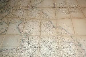
Cheffins's Map of the Railways in Great Britain: From the Ordnance Surveys
Verlag: Chas. F. Cheffins, London, 1848
Anbieter: Classic Books and Ephemera, IOBA, Lansdowne, PA, USA
Verbandsmitglied: IOBA
Verkäuferbewertung 5 von 5 Sternen
Manuskript / Papierantiquität
Map. Zustand: Good. "Published by Chas. F. Cheffins, 9 Southampton Buildings, Holborn. And W.S. Orr & Co. Paternoster Row. Also by Wareing Webb, Castle Street, Liverpool." 1 map: handcolored engraved map; dissected and mounted on linen; 126 x 96 cm., folded to 20 x 13 cm. Scale: 10 miles to 1 inch. Front cover is blind-stamped cloth board; back cover is stiffened marbled paper. Small circular label for William Lipton Ltd. on back cover. In Good Condition: linen has separated along several folds, but no sections are entirely detached; some old repairs on the back; clean and bright. A very scarce mid-19th-century railway map.