Gesamtpreis (1 Artikel Artikel):
Versandziel:

cruchleys (3 Ergebnisse)
Direkt zu den wichtigsten Suchergebnissen
Suchfilter
Produktart
- Alle Product Types
- Bücher (2)
- Magazine & Zeitschriften (Keine weiteren Ergebnisse entsprechen dieser Verfeinerung)
- Comics (Keine weiteren Ergebnisse entsprechen dieser Verfeinerung)
- Noten (Keine weiteren Ergebnisse entsprechen dieser Verfeinerung)
- Kunst, Grafik & Poster (Keine weiteren Ergebnisse entsprechen dieser Verfeinerung)
- Fotografien (Keine weiteren Ergebnisse entsprechen dieser Verfeinerung)
- Karten (1)
- Manuskripte & Papierantiquitäten (Keine weiteren Ergebnisse entsprechen dieser Verfeinerung)
Zustand Mehr dazu
- Neu (Keine weiteren Ergebnisse entsprechen dieser Verfeinerung)
- Wie Neu, Sehr Gut oder Gut Bis Sehr Gut (Keine weiteren Ergebnisse entsprechen dieser Verfeinerung)
- Gut oder Befriedigend (1)
- Ausreichend oder Schlecht (Keine weiteren Ergebnisse entsprechen dieser Verfeinerung)
- Wie beschrieben (2)
Einband
- alle Einbände
- Hardcover (2)
- Softcover (Keine weiteren Ergebnisse entsprechen dieser Verfeinerung)
Weitere Eigenschaften
- Erstausgabe (Keine weiteren Ergebnisse entsprechen dieser Verfeinerung)
- Signiert (Keine weiteren Ergebnisse entsprechen dieser Verfeinerung)
- Schutzumschlag (Keine weiteren Ergebnisse entsprechen dieser Verfeinerung)
- Angebotsfoto (2)
- Keine Print-on-Demand Angebote (3)
Sprache (1)
Preis
- Beliebiger Preis
- Weniger als EUR 20 (Keine weiteren Ergebnisse entsprechen dieser Verfeinerung)
- EUR 20 bis EUR 45 (Keine weiteren Ergebnisse entsprechen dieser Verfeinerung)
- Mehr als EUR 45
Gratisversand
- Kostenloser Versand nach USA (Keine weiteren Ergebnisse entsprechen dieser Verfeinerung)
Land des Verkäufers
Verkäuferbewertung
-
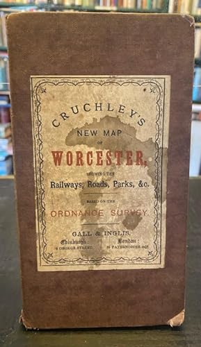
Cruchley's New Map of Worcester, showing the Railways, Roads, Parks, &c. Based on the Ordinance Survey
Verlag: Gall & Inglis ca. 1880, Edinburgh and London, 1880
Anbieter: Foster Books - Stephen Foster - ABA, ILAB, & PBFA, London, Vereinigtes Königreich
Verbandsmitglied: ABA ILAB PBFA
Verkäuferbewertung 5 von 5 Sternen

EUR 48,44
EUR 14,70 Versand
Versand von Vereinigtes Königreich nach USAAnzahl: 1 verfügbar
In den WarenkorbCloth. Zustand: Good. Brown cloth binding with fold out map (complete). Staining to front board and fading to spine, browning and small ink mark to map. Front board detatched at spine. Overall in G/VG condition. 'Littlebury's Map of Worcestershire, published expressly to accompany the postal and commercial directory and gazetteer of Worcester and district'. 12mo. Folding Map.
-

RAILWAY AND STATION MAP OF ENGLAND AND WALES, With the Principal Part of Scotland. Improved from the Ordnance Surveys. Size 8 Feet 2 In. by 6 Feet 2 In.
Verlag: G.F. Cruchley Map Publisher & Globe Maker N.d. c., 1852
Anbieter: Francis Edwards ABA ILAB, Hay on Wye, Vereinigtes Königreich
Verbandsmitglied: ABA ILAB PBFA
Verkäuferbewertung 5 von 5 Sternen
EUR 119,90
EUR 25,87 Versand
Versand von Vereinigtes Königreich nach USAAnzahl: 1 verfügbar
In den WarenkorbTitle page + Double page index map + 78 double page maps printed both side of the paper, [without blank sheets 62, 71 and 80 as issued]. Each double page measuring 7.75 x 10 inches. Hand coloured. Some minor browning, many leaves detached, bound in leather, rubbed. Scarce. US$133.
-
Cruchley's Improved Geographical Companion Throughout England and Wales, Including Part of Scotland
Verlag: Published by G.F. Cruchley, Mapseller, London, 1829
Anbieter: Keoghs Books, Skipton, Vereinigtes Königreich
Verbandsmitglied: PBFA
Verkäuferbewertung 5 von 5 Sternen
Karte
EUR 272,49
EUR 32,92 Versand
Versand von Vereinigtes Königreich nach USAAnzahl: 1 verfügbar
In den Warenkorb, folded in 25 sections. Hand coloured in outline, title on cover "Cruchley's New Map of England and Wales" Early Edition , cover scuffed with closed tears at the bottom, some foxing to reverse of map - two sections are also signed by a previous owner, map is in good condition. , map on linen folding into paper cover, paper title label with coloured text , 19.5 x 13.5 cm (folded), 97.5 x 68 cm (open) Map ISBN: