Gesamtpreis (1 Artikel Artikel):
Versandziel:

engraved map (263 Ergebnisse)
Direkt zu den wichtigsten Suchergebnissen
Suchfilter
Produktart
- Alle Product Types
- Bücher (204)
- Magazine & Zeitschriften (Keine weiteren Ergebnisse entsprechen dieser Verfeinerung)
- Comics (Keine weiteren Ergebnisse entsprechen dieser Verfeinerung)
- Noten (Keine weiteren Ergebnisse entsprechen dieser Verfeinerung)
- Kunst, Grafik & Poster (41)
- Fotografien (Keine weiteren Ergebnisse entsprechen dieser Verfeinerung)
- Karten (18)
- Manuskripte & Papierantiquitäten (Keine weiteren Ergebnisse entsprechen dieser Verfeinerung)
Zustand Mehr dazu
- Neu (Keine weiteren Ergebnisse entsprechen dieser Verfeinerung)
- Wie Neu, Sehr Gut oder Gut Bis Sehr Gut (1)
- Gut oder Befriedigend (249)
- Ausreichend oder Schlecht (Keine weiteren Ergebnisse entsprechen dieser Verfeinerung)
- Wie beschrieben (13)
Weitere Eigenschaften
- Erstausgabe (72)
- Signiert (Keine weiteren Ergebnisse entsprechen dieser Verfeinerung)
- Schutzumschlag (Keine weiteren Ergebnisse entsprechen dieser Verfeinerung)
- Angebotsfoto (78)
- Keine Print-on-Demand Angebote (263)
Sprache (4)
Gratisversand
Land des Verkäufers
Verkäuferbewertung
-
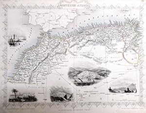
steal engraving / Grenzcolorierter Stahlstich Northern Africa. Mit weiteren 5 Bildstahlstichen 1)Mogador. 2) Marocco. 3) Constantine. 4) Algiers. 5)Tunis.
Sprache: Englisch
Verlag: The London Printing and Publishing Company. o.J. [ca 1850], 1850
Anbieter: Antiquariat Carl Wegner, Berlin, B, Deutschland
Verbandsmitglied: GIAQ
Verkäuferbewertung 5 von 5 Sternen

Erstausgabe
Softcover. Blattgröße 27x36 cm, Stichgröße 21 x 30 cm, mittig längs gefaltet. Die Tafel mit floraler Rahmung, eingezeichneten Längen- und Breitengraden und Maßstabsangabe. Das Blatt an den Rändern und in der Querfalte leicht lichtrandig und fingerfleckig, an der linken unteren Ecke eine Faltstelle, sonst schönes Exemplar. --- In english language. Good condition. Die Tafel beschriftet mit der Ziffer 61. Wahrscheinlich die entsprechende Tafel aus dem Werk von John Tallis: Illustrated atlas and modern history of the world. -- Zu dekorativen Zwecken, zum Rahmen geeignet. Weitere Karten aus dem gleichen Werk vorhanden. "John Rapkin was a mapmaker who was concerned with the aesthetic value of his work as well as cartographic content. His fine maps are distinguished by the trademark decorative borders, vignettes and title displays. Rapkin worked in close association with the equally respected publisher John Tallis. The publishing rights of many of the maps passed to The London Printing and Publishing Company circa 1850. " -- Bitte Portokosten außerhalb EU erfragen! / Please ask for postage costs outside EU! / S ' il vous plait demander des frais de port en dehors de l ' UE! // Bitte beachten Sie auch unsere Fotos! / Please also note our photos! / Veuillez noter nos photos -- Nehmen Sie sich ein gutes Buch mit auf die Sommerwiese. Bei uns werden Sie fündig! -- Wir kaufen Ihre werthaltigen Bücher! GM25-502030.
-

Herefordshire.
Verlag: Chapman & Hall., London.
Anbieter: N. G. Lawrie Books, Sheffield, Vereinigtes Königreich
Verkäuferbewertung 5 von 5 Sternen
Karte
EUR 4,76
EUR 10,98 Versand
Versand von Vereinigtes Königreich nach USAAnzahl: 1 verfügbar
In den WarenkorbZustand: Very Good. Engraved map, circa 1850s (approx 10 1/2 x 8 inches including margins), with original colour in outline. Light tan along the centre fold.
-

Westmoreland.
Verlag: Chapman & Hall., London.
Anbieter: N. G. Lawrie Books, Sheffield, Vereinigtes Königreich
Verkäuferbewertung 5 von 5 Sternen
Karte
EUR 4,76
EUR 10,98 Versand
Versand von Vereinigtes Königreich nach USAAnzahl: 1 verfügbar
In den WarenkorbZustand: Very Good. Engraved map, circa 1850s (approx 8 x 10 1/2 inches including margins), with original colour in outline. Light tan along the centre fold.
-

Bedfordshire.
Verlag: Chapman & Hall., London.
Anbieter: N. G. Lawrie Books, Sheffield, Vereinigtes Königreich
Verkäuferbewertung 5 von 5 Sternen
Karte
EUR 4,76
EUR 10,98 Versand
Versand von Vereinigtes Königreich nach USAAnzahl: 1 verfügbar
In den WarenkorbZustand: Good+. Engraved map, circa 1850s (approx 10 1/2 x 8 inches including margins), with original colour in outline. Small split along the centre fold.
-

Buckinghamshire.
Verlag: Chapman & Hall., London.
Anbieter: N. G. Lawrie Books, Sheffield, Vereinigtes Königreich
Verkäuferbewertung 5 von 5 Sternen
Karte
EUR 4,76
EUR 10,98 Versand
Versand von Vereinigtes Königreich nach USAAnzahl: 1 verfügbar
In den WarenkorbZustand: Good+. Engraved map, circa 1850s (approx 10 1/2 x 8 inches including margins), with original colour in outline. Small split along the centre fold.
-
Peru, Bolivian Tablelands.
Verlag: A. Fullarton & Co., London & Edinburgh.
Anbieter: N. G. Lawrie Books, Sheffield, Vereinigtes Königreich
Verkäuferbewertung 5 von 5 Sternen
Karte
EUR 5,95
EUR 10,98 Versand
Versand von Vereinigtes Königreich nach USAAnzahl: 1 verfügbar
In den WarenkorbZustand: Good+. Undated, circa 1860s. Original steel engraved map with colouring. Overall measures approx 10 1/4 x 6 1/2 inches including margins. Paper a little browned.
-

Whittaker's Improved Edition of Pinnock's England : from the invasion of Julius Caesar to the Being of Victoria's Reign
Sprache: Englisch
Verlag: Whittaker & Co, London
Anbieter: J J Basset Books, bassettbooks, bookfarm.co.uk, Peter Tavy, Vereinigtes Königreich
Verkäuferbewertung 4 von 5 Sternen

EUR 17,86
EUR 23,12 Versand
Versand von Vereinigtes Königreich nach USAAnzahl: 1 verfügbar
In den WarenkorbLeather. Zustand: Good. No Jacket. 2 engraved plates, folding map with hand coloured outlines, a number of woodcuts in text. (illustrator). This is the Twenty Fourth Edition. No date published circa 1876.Two engraved plates, folding map of Roman britain (loose) with hand coloured outlines, a number of woodcuts in text.520pp + adverts SHAKEN but all text good, book reallly needs restitching Size: 12mo - over 6ľ" - 7ľ". Sighed BY Mr John Williams (Co.
-
The Canadian Almanac For The Year 1886. Original Edition.Not a reprint.
Sprache: Englisch
Verlag: Copp, Clark Compay (Limited), Toronto, Canada, 1886
Anbieter: Old Favorites Bookshop LTD (since 1954), Stouffville, ON, Kanada
Verkäuferbewertung 5 von 5 Sternen
Paper Covers. Stapled Binding. Zustand: Good Condition, Fold Out Map of Part of the North West Territory Engraved for The Canadian Almanac 1886 (illustrator). Front and back covers missing.Map in good condition folded and loose at front of book. 171pp Content clean, bright and sound with paper lightly tanned. Size 21.5cm x 14.5cm x 1cm . photos available on request. May require additional postage.
-
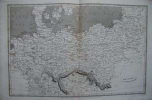
Prussia Map.
Verlag: Longman, Hurst, Rees & Orme., London., 1808
Anbieter: N. G. Lawrie Books, Sheffield, Vereinigtes Königreich
Verkäuferbewertung 5 von 5 Sternen
Karte
EUR 17,86
EUR 10,98 Versand
Versand von Vereinigtes Königreich nach USAAnzahl: 1 verfügbar
In den WarenkorbMap. Zustand: Very Good. Engraved by Lowry after Arrowsmith. Published in Ree's Cyclopedia or Universal Dictionary, early 1800s. Overall measures 11 1/4 x 17 1/4 inches. Centre fold and light spotting.
-
COLOURED MAP OF NEW ZEALAND, 1865
Sprache: Englisch
Verlag: EDWARD STANFORD, London, 1865
Anbieter: K Books Ltd ABA ILAB, York, YORKS, Vereinigtes Königreich
Verbandsmitglied: ABA ILAB PBFA
Verkäuferbewertung 5 von 5 Sternen
EUR 23,81
EUR 22,54 Versand
Versand von Vereinigtes Königreich nach USAAnzahl: 1 verfügbar
In den WarenkorbNo Binding. Zustand: Very Good. Engraved By J & C WALKER (illustrator). Shows all the settlements coloured in red. Shows bays, mountains, volcanoes, islands, harbours etc. The map has a central fold, with a short tear in the margin which has been neatly mended.
-
COLOURED MAP OF SOUTH AFRICA, 1865
Sprache: Englisch
Verlag: EDWARD STANFORD, London, 1865
Anbieter: K Books Ltd ABA ILAB, York, YORKS, Vereinigtes Königreich
Verbandsmitglied: ABA ILAB PBFA
Verkäuferbewertung 5 von 5 Sternen
EUR 23,81
EUR 22,54 Versand
Versand von Vereinigtes Königreich nach USAAnzahl: 1 verfügbar
In den WarenkorbNo Binding. Zustand: Very Good. Engraved By J & C WALKER (illustrator). Shows the German Military Posts and Villages situated along along the roads on either side of the Buffalo River in British Kaffraria, the railways etc. 4 insets of the Cape, the District of George, the Environs of Graham Town and Cape Town. The map has a central fold, with a short tear in the margin which has been neatly mended.
-
COLOURED MAP OF THE ANTILLES OR WEST-INDIA ISLANDS, 1865
Sprache: Englisch
Verlag: EDWARD STANFORD, London, 1865
Anbieter: K Books Ltd ABA ILAB, York, YORKS, Vereinigtes Königreich
Verbandsmitglied: ABA ILAB PBFA
Verkäuferbewertung 5 von 5 Sternen
EUR 23,81
EUR 22,54 Versand
Versand von Vereinigtes Königreich nach USAAnzahl: 1 verfügbar
In den WarenkorbNo Binding. Zustand: Very Good. Engraved By J & C WALKER (illustrator). Gives the dimensions in square miles of all the islands, dividing them up into British, French, Spanish, Dutch, Swedish and Danish. Shows forts, volcanoes, harbours etc. The map has a central fold, with a short tear in the margin which has been neatly mended.
-
BEAUFORT HUNT, ANTIQUE MAP OF THE BEAUFORT COUNTRY . A Fine Original Antique Hand Coloured Engraving .
Sprache: Englisch
Verlag: J MITCHELL, London, 1841
Anbieter: K Books Ltd ABA ILAB, York, YORKS, Vereinigtes Königreich
Verbandsmitglied: ABA ILAB PBFA
Verkäuferbewertung 5 von 5 Sternen
Erstausgabe
EUR 29,76
EUR 22,54 Versand
Versand von Vereinigtes Königreich nach USAAnzahl: 1 verfügbar
In den WarenkorbNo Binding. Zustand: Very Good. No Jacket. First Edition. A fine original antique hand coloured engraving. Hand coloured - colouring not contemporary but delicately and expertly executed . . Mounted and ready to frame . . Very good condition, . A splendid opportunity to acquire an antique original view - decorative, attractive and scarce . A splendid scene --fine MAP OF THE BEAUFORT HUNT COUNTRY PRINTED IN 1841.
-
PYTCHLEY HUNT, ANTIQUE MAP OF THE BEAUFORT COUNTRY . A Fine Original Antique Hand Coloured Engraving .
Sprache: Englisch
Verlag: J MITCHELL, London, 1841
Anbieter: K Books Ltd ABA ILAB, York, YORKS, Vereinigtes Königreich
Verbandsmitglied: ABA ILAB PBFA
Verkäuferbewertung 5 von 5 Sternen
Erstausgabe
EUR 29,76
EUR 22,54 Versand
Versand von Vereinigtes Königreich nach USAAnzahl: 1 verfügbar
In den WarenkorbNo Binding. Zustand: Very Good. No Jacket. First Edition. A fine original antique hand coloured engraving. Hand coloured - colouring not contemporary but delicately and expertly executed . . Mounted and ready to frame . . Very good condition, . A splendid opportunity to acquire an antique original view - decorative, attractive and scarce . A splendid scene --fine MAP OF THE PYTCHLEY HUNT COUNTRY PRINTED IN 1841.
-
BURTON HUNT, LINCOLN, HUNT, ANTIQUE MAP OF THE BEAUFORT COUNTRY . A Fine Original Antique Hand Coloured Engraving .
Sprache: Englisch
Verlag: J MITCHELL, London, 1841
Anbieter: K Books Ltd ABA ILAB, York, YORKS, Vereinigtes Königreich
Verbandsmitglied: ABA ILAB PBFA
Verkäuferbewertung 5 von 5 Sternen
Erstausgabe
EUR 29,76
EUR 22,54 Versand
Versand von Vereinigtes Königreich nach USAAnzahl: 1 verfügbar
In den WarenkorbNo Binding. Zustand: Very Good. No Jacket. First Edition. A fine original antique hand coloured engraving. Hand coloured - colouring not contemporary but delicately and expertly executed . . Mounted and ready to frame . . Very good condition, . A splendid opportunity to acquire an antique original view - decorative, attractive and scarce . A splendid scene --fine MAP OF THE BURTON HUNT COUNTRY , NEAR LINCOLN, PRINTED IN 1841.
-
OAKLEY HUNT, ANTIQUE MAP OF THE BEAUFORT COUNTRY . A Fine Original Antique Hand Coloured Engraving .
Sprache: Englisch
Verlag: J MITCHELL, London, 1841
Anbieter: K Books Ltd ABA ILAB, York, YORKS, Vereinigtes Königreich
Verbandsmitglied: ABA ILAB PBFA
Verkäuferbewertung 5 von 5 Sternen
Erstausgabe
EUR 29,76
EUR 22,54 Versand
Versand von Vereinigtes Königreich nach USAAnzahl: 1 verfügbar
In den WarenkorbNo Binding. Zustand: Very Good. No Jacket. First Edition. A fine original antique hand coloured engraving. Hand coloured - colouring not contemporary but delicately and expertly executed . . Mounted and ready to frame . . Very good condition, . A splendid opportunity to acquire an antique original view - decorative, attractive and scarce . A splendid scene --fine MAP OF THE OAKLEY HUNT COUNTRY PRINTED IN 1841.
-
HYETOGRAPHIC OR RAIN MAP OF EUROPE - an Original Antique Coloured Map, Published 1849
Sprache: Englisch
Verlag: William Blackwood & Sons, Edinburgh, 1849
Anbieter: K Books Ltd ABA ILAB, York, YORKS, Vereinigtes Königreich
Verbandsmitglied: ABA ILAB PBFA
Verkäuferbewertung 5 von 5 Sternen
EUR 29,76
EUR 22,54 Versand
Versand von Vereinigtes Königreich nach USAAnzahl: 1 verfügbar
In den WarenkorbNo Binding. Zustand: Very Good. Engraved By A K Johnston (illustrator). An original antique map, printed in 1849, but showing no date of publication. The map was drawn by Professor Berghaus, engraved by A K Johnston. Minimal contemporary colouring. Unmounted - will be posted rolled in a tube. Very good condition. The explanation at the bottom of the map gives information about the shading, together with a note that the map has been drawn to a scale of French inches, 15 of which of which are equal to 16 English inches. There are also 2 pages of additional information.
-
HYETOGRAPHIC OR RAIN MAP OF THE WORLD - an Original Antique Coloured Map, Published 1849
Sprache: Englisch
Verlag: William Blackwood & Sons, Edinburgh, 1849
Anbieter: K Books Ltd ABA ILAB, York, YORKS, Vereinigtes Königreich
Verbandsmitglied: ABA ILAB PBFA
Verkäuferbewertung 5 von 5 Sternen
EUR 29,76
EUR 22,54 Versand
Versand von Vereinigtes Königreich nach USAAnzahl: 1 verfügbar
In den WarenkorbNo Binding. Zustand: Very Good. Engraved By W & A K Johnston (illustrator). An original antique map, printed in 1849, but showing no date of publication. The map has been extended by Professor Berghaus, engraved by W & A K Johnston. Minimal contemporary colouring. Unmounted - will be posted rolled in a tube. Very good condition. The key at the bottom of the map offers details of the amount of rain the various zones, showing increase and decrease, and details of the significance of the shading of the map. There are also 2 pages of additional information.
-
Switzerland - Detailed Map Showing Roads, Towns , Explanation of the Signs Etc - an Original Antique Engraved Map
Sprache: Englisch
Verlag: George Virtue, 1836
Anbieter: K Books Ltd ABA ILAB, York, YORKS, Vereinigtes Königreich
Verbandsmitglied: ABA ILAB PBFA
Verkäuferbewertung 5 von 5 Sternen
EUR 29,76
EUR 22,54 Versand
Versand von Vereinigtes Königreich nach USAAnzahl: 1 verfügbar
In den WarenkorbNo Binding. Zustand: Very Good, Some Folds Showing. Engraved By Starling (illustrator). An original antique engraved map, printed circa 1836. Hand-colouring not contemporary but delicately and expertly executed. Mounted and ready to frame. A fine opportunity to purchase an attractive and decorative map - Switzerland - Detailed Map Showing Roads, Towns , Explanation of the Signs.
-
Cadiz and Environs in 1812 - Showing the Seat of War with Encampments and Arsnel of the Carracas Etc - an Original Antique Engraved Map
Sprache: Englisch
Verlag: Fisher & Son, 1840
Anbieter: K Books Ltd ABA ILAB, York, YORKS, Vereinigtes Königreich
Verbandsmitglied: ABA ILAB PBFA
Verkäuferbewertung 5 von 5 Sternen
EUR 29,76
EUR 22,54 Versand
Versand von Vereinigtes Königreich nach USAAnzahl: 1 verfügbar
In den WarenkorbNo Binding. Zustand: Very Good. An original antique engraved map, printed circa 1840. Hand-colouring not contemporary but delicately and expertly executed. Mounted and ready to frame. A fine opportunity to purchase an attractive and decorative map - Cadiz and Environs - Showing the Seat of War with Encampments and Arsnel of the Carracas Etc.
-
Ancient Antioch - After Muller - Showing the City of Seleucus, Mount Silphius Etc - an Original Antique Engraved Map
Sprache: Englisch
Verlag: Longman, Brown, Green and Longmans, 1840
Anbieter: K Books Ltd ABA ILAB, York, YORKS, Vereinigtes Königreich
Verbandsmitglied: ABA ILAB PBFA
Verkäuferbewertung 5 von 5 Sternen
EUR 29,76
EUR 22,54 Versand
Versand von Vereinigtes Königreich nach USAAnzahl: 1 verfügbar
In den WarenkorbNo Binding. Zustand: Very Good. Engraved By w. Hughes (illustrator). An original antique engraved map, printed circa 1840. Hand-colouring not contemporary but delicately and expertly executed. Mounted and ready to frame. A fine opportunity to purchase an attractive and decorative map - Ancient Antioch - After Muller - Showing the City of Seleucus, Mount Silphius Etc.
-
Asia - Antiquarian Coloured Map
Sprache: Englisch
Verlag: Collins, London
Anbieter: K Books Ltd ABA ILAB, York, YORKS, Vereinigtes Königreich
Verbandsmitglied: ABA ILAB PBFA
Verkäuferbewertung 5 von 5 Sternen
EUR 29,76
EUR 22,54 Versand
Versand von Vereinigtes Königreich nach USAAnzahl: 1 verfügbar
In den WarenkorbNo Binding. Zustand: Very Good. Engraved & Drawn By J Archer (illustrator). An original antique map of Asia, printed ca. 1840. Mounted and ready to frame. Contemporary colouring in outline. In excellent condition, decorative and impressive. A clear map showing the main Empires & Countries of Asia from the Mediterranean to Japan.
-
Map of Oxfordshire - an Original Antique Engraving
Sprache: Englisch
Erscheinungsdatum: 1890
Anbieter: K Books Ltd ABA ILAB, York, YORKS, Vereinigtes Königreich
Verbandsmitglied: ABA ILAB PBFA
Verkäuferbewertung 5 von 5 Sternen
EUR 17,86
EUR 22,54 Versand
Versand von Vereinigtes Königreich nach USAAnzahl: 1 verfügbar
In den WarenkorbNo Binding. Zustand: Very Good. An original hand-coloured antique engraved map, printed circa 1890. Hand-colouring contemporary. Mounted/matted and ready to frame. A fine opportunity to purchase an attractive and decorative engraving of a Map of Oxfordshire.
-
The Merchant Magazine, Volume XIX, Number I, July, 1848
Verlag: Freeman Hunt, NY, 1848
Anbieter: Clausen Books, RMABA, Colorado Springs, CO, USA
Verkäuferbewertung 5 von 5 Sternen
Brown, Printed Wraps. Zustand: Good+. Engraved Frontispiece; Tipped in Map of New York City (illustrator). Engraved frontispiece James William Gilbart, General Manager of the London and Westminster Bank; Onion skin map of New York City tipped in at the ffep; A well age-worn, original copy, not a reprint; usual age toning and handling, else textblock is clean and tight; Peeling to head and foot of spine, wear to edges and creased corners. Pages 19-128; This issue includes: Internal Commerce of the West; Commercial Cities and Towns of the United States; Commercial Code of Spain; The Mercantile House of A. and S. Henry and Co; James William Gilbart, and much, much more. Size: 8vo - over 7ľ" - 9ľ" tall. Paperback.
-
SCOTLAND MAP. An Original Hand-Coloured Engraved Map.
Sprache: Englisch
Verlag: BRIGHTLY & KENNEDY, Bungay, Suffolk, 1807
Anbieter: K Books Ltd ABA ILAB, York, YORKS, Vereinigtes Königreich
Verbandsmitglied: ABA ILAB PBFA
Verkäuferbewertung 5 von 5 Sternen
EUR 35,72
EUR 22,54 Versand
Versand von Vereinigtes Königreich nach USAAnzahl: 1 verfügbar
In den WarenkorbNo Binding. Zustand: Very Good. Barlow (illustrator). An original, hand-coloured engraved map; colouring not contemporary, but delicately and expertly done. Will come mounted (matted) and ready to frame - mount size 13 x 11 inches. An opportunity to buy a decorative and attractive antique map of Scotland.
-
GERMANY MAP. An Original Hand-Coloured Engraved Map.
Sprache: Englisch
Verlag: BRIGHTLY & KENNEDY, Bungay, Suffolk, 1807
Anbieter: K Books Ltd ABA ILAB, York, YORKS, Vereinigtes Königreich
Verbandsmitglied: ABA ILAB PBFA
Verkäuferbewertung 5 von 5 Sternen
EUR 35,72
EUR 22,54 Versand
Versand von Vereinigtes Königreich nach USAAnzahl: 1 verfügbar
In den WarenkorbNo Binding. Zustand: Very Good. Barlow (illustrator). An original, hand-coloured engraved map; colouring not contemporary, but delicately and expertly done. Will come mounted (matted) and ready to frame - mount size 13 x 11 inches. An opportunity to buy a decorative and attractive antique map of Germany.
-
ENGLAND AND WALES MAP. An Original Hand-Coloured Engraved Map.
Sprache: Englisch
Verlag: BRIGHTLY & KENNEDY, Bungay, Suffolk, 1807
Anbieter: K Books Ltd ABA ILAB, York, YORKS, Vereinigtes Königreich
Verbandsmitglied: ABA ILAB PBFA
Verkäuferbewertung 5 von 5 Sternen
EUR 35,72
EUR 22,54 Versand
Versand von Vereinigtes Königreich nach USAAnzahl: 1 verfügbar
In den WarenkorbNo Binding. Zustand: Very Good. Barlow (illustrator). An original, hand-coloured engraved map; colouring not contemporary, but delicately and expertly done. Will come mounted (matted) and ready to frame - mount size 13 x 11 inches. An opportunity to buy a decorative and attractive antique map of England and Wales.
-
SPAIN AND PORTUGAL. An Original Hand-Coloured Engraved Map.
Sprache: Englisch
Verlag: BRIGHTLY & KENNEDY, Bungay, Suffolk, 1807
Anbieter: K Books Ltd ABA ILAB, York, YORKS, Vereinigtes Königreich
Verbandsmitglied: ABA ILAB PBFA
Verkäuferbewertung 5 von 5 Sternen
EUR 35,72
EUR 22,54 Versand
Versand von Vereinigtes Königreich nach USAAnzahl: 1 verfügbar
In den WarenkorbNo Binding. Zustand: Very Good. Barlow (illustrator). An original, hand-coloured engraved map; colouring not contemporary, but delicately and expertly done. Will come mounted (matted) and ready to frame - mount size 13 x 11 inches. An opportunity to buy a decorative and attractive antique map of Spain and Portugal.
-
France. An Original Hand-Coloured Engraved Map.
Sprache: Englisch
Verlag: BRIGHTLY & KENNEDY, Bungay, Suffolk, 1807
Anbieter: K Books Ltd ABA ILAB, York, YORKS, Vereinigtes Königreich
Verbandsmitglied: ABA ILAB PBFA
Verkäuferbewertung 5 von 5 Sternen
EUR 35,72
EUR 22,54 Versand
Versand von Vereinigtes Königreich nach USAAnzahl: 1 verfügbar
In den WarenkorbNo Binding. Zustand: Very Good. Barlow (illustrator). An original, hand-coloured engraved map; colouring not contemporary, but delicately and expertly done. Will come mounted (matted) and ready to frame - mount size 13 x 11 inches. An opportunity to buy a decorative and attractive antique map of France, divided into Circles and Departments.
-
IRELAND MAP. An Original Hand-Coloured Engraved Map.
Sprache: Englisch
Verlag: BRIGHTLY & KENNEDY, Bungay, Suffolk, 1807
Anbieter: K Books Ltd ABA ILAB, York, YORKS, Vereinigtes Königreich
Verbandsmitglied: ABA ILAB PBFA
Verkäuferbewertung 5 von 5 Sternen
EUR 35,72
EUR 22,54 Versand
Versand von Vereinigtes Königreich nach USAAnzahl: 1 verfügbar
In den WarenkorbNo Binding. Zustand: Very Good. Barlow (illustrator). An original, hand-coloured engraved map; colouring not contemporary, but delicately and expertly done. Will come mounted (matted) and ready to frame - mount size 13 x 11 inches. An opportunity to buy a decorative and attractive antique map of Ireland.