George willdey (6 Ergebnisse)

Verlag: [London, c.1740]. 525 x 530mm (20¾ x 20¾ inches). 1740
Anbieter: Tooley, Adams & Co., Wallingford, OXON, Vereinigtes KönigreichTooley, Adams & Co.
Verkäufer/-in kontaktierenVerkäufer/-in mit 3 SternenZustand: Gebraucht
EUR 857,18
EUR 42,94 VersandVersand von Vereinigtes Königreich nach USAAnzahl: 1 verfügbar
Uncoloured; signs of old folds on verso from a smaller volume, contemporary ink manuscript addition on the verso An apparently unrecorded later state of Willdey's 1713 map, lacking the heavily decorated and scrolled spandrels and outer border and with the George Willdey imprint removed, bottom right. The old folds visible on the… verso would indicate that the map was folded and bound, possibly in a small road book, but we can find no record. Not recorded in Shirley. Earlier editions - R. W. Shirley. Printed Maps of the British Isles 1650 - 1750, Willdey 1. Note in pencil on verso; 'Willdey 1.3 state 3 of 3, 1 of 4 recorded examples.
Verlag: Sold [by] George [Will]dey at y.e Grea[t Toy], Spectacle & P[rint]shop or Grand M[aga]zine [of] Curio[sities .] y.e Corner of Lu[dga]te Street next St. [Pauls], [1721]., London, 1721
- Karte
Anbieter: Daniel Crouch Rare Books Ltd, London, , Vereinigtes KönigreichDaniel Crouch Rare Books Ltd
Verkäufer/-in kontaktierenVerkäufer/-in mit 4 SternenZustand: Gebraucht
EUR 190.485,47
EUR 23,12 VersandVersand von Vereinigtes Königreich nach USAAnzahl: 1 verfügbar
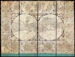
".one of the largest, beautifullest, most useful, and diverting Ornaments." Engraved map of the world, printed on four sheets joined, surrounded by 20 engraved circular and ovoid maps, all with original outline hand-colour, mounted on canvas on a four fold screen, some loss to edges of screen affecting title and imprint, a few m…aps with areas of loss, the majority skilfully repaired in facsimile, decorative border below, some cleaning and restoration to furniture. George Willdey's magnificent atlas of World in the form of a screen. The present screen consists George Willdey's large four-sheet world map, surrounded by twenty oval or circular maps, and was advertised by Willdey in the Post Man (issue 4112) on the 23rd - 25th November 1721: "A large New and Correct English Map of the World, laid down according to the newest and most accurate Observations and Discoveries made by the Royal Society of London, and the Royal Academy of Sciencies [sic] at Paris, in several different Projections, including the Trade Winds, Monsoons, Variations of the Compass, and illustrated with the Ptolemick, Copernick, and Tychonick Systems, and the Appearances of the Planets, and shews the Hour of the Day in every Kingdom, and Place upon the Earth; with many useful and ornamental Explanations: This Map is 3 Foot 4 Inches deep, and 6 Foot 4 Inches long, and round the same is added, instead of useless Ornaments, a Set of 20 different New Sheet Maps, of the Principal Kingdoms and States of Europe, with particular Historical Explanations to each Map, so as to make it when put together, with its proper Colours and Illuminations, one of the largest, beautifullest, most useful, and diverting Ornaments, as well as best Set of Geography ever yet done of this kind; the Names of the Maps aforesaid, are a Northern Celestial Hemisphere, a Southern, ditto England, Scotland, Ireland, 20 Miles round London, 20 Miles round Oxford, 20 Miles round Cambridge, Germany, France, Spain, Italy, Sweedland, Poland, Denmark, Muscovy, Hungary, the Turks Dominions in Europe, Flanders, and the Seven United Provinces. This Set of Maps may be fitted up several ways and sizes, or bound in a Book, or Sold single, to fit Gentlemens Conveniency; it is done by the Direction and Charge, and Sold by George Willdey, at the Great Toy, Spectacle and Print-Shop, at the Corner of Ludgate street, next St. Pauls, London; where Gentlemen may be furnished with large 2 sheet Maps, fine Prints, Cutlers Ware, and Curious Toys in Gold, Silver, and other Curious Metals and Materials the best of Spectacles, Tellescopes, Reading Glasses, Perspective Glasses, &c. of all which no Person in Europe hath better Goods, better Choice, or Sells more Reasonable." As one can discern from the elaborate - and somewhat overwrought - text in the above advertisement, George Willdey (?1671-1737) was a flamboyant London shopkeeper and self-publicist. His principal business was a a toy-man and seller of luxury goods, jewellery, gold and silver trinkets, and china. However, he was perhaps the first mapseller to widen the appeal of maps from an intellectual elite to the general public. In this respect the map screen must be seen as his most ambitious attempt to broaden their appeal. That he was successful in his aim can be seen from the fact that the playwright John Sheridan mentions them in his comedy, 'School for Scandal' - some 50 years later - in 1777. As Peter Barber states in the entry on the British Library's example, exhibited in their Magnificent Maps exhibition, in 2010: "They [the screens] would have given a flattering impression of the extent of its owner's knowledge and interests, and would have provided an informal geographical education for family, visitors and servants alike." Although evidently popular throughout the Georgian Period, only two other examples of Willdey's work are known: 1) British Library - dated circa 1750; the world map bearing the imprint of Thomas Jefferys, who had purchased the plates f.
 Weitere Bilder
Verlag: [c1721]., London, 1721
Anbieter: Daniel Crouch Rare Books Ltd, London, , Vereinigtes KönigreichDaniel Crouch Rare Books Ltd
Verkäufer/-in kontaktierenVerkäufer/-in mit 4 SternenZustand: Gebraucht
EUR 89.290,06
EUR 23,12 VersandVersand von Vereinigtes Königreich nach USAAnzahl: 1 verfügbar
Willdey's rare composite atlas Large folio (482 by 317 mm). 21 double page maps, 19 in original outline hand colour, brown calf, gilt, turn-ins gilt, spine divided into six compartments by raised bands, gilt fillets and title in gilt lettering. A composite atlas by George Willdey, made up of unusual round maps with information a…bout the areas portrayed included in small roundels in the black border surrounding the cartographical elements. Although the atlas has no title page, it was in all likelihood compiled by Willdey's establishment. The maps are almost identical to the series advertised by Willdey in 'Post Man' (issue 4112) on the 23rd-25th November 1721: "a Set of 20 different New Sheet Maps, of the Principal Kingdoms and States of Europe, with particular Historical Explanations to each Map, so as to make it when put together, with its proper Colours and Illuminations, one of the largest, beautifullest, most useful, and diverting Ornaments, as well as best Set of Geography ever yet done of this kind; the Names of the Maps aforesaid, are a Northern Celestial Hemisphere, a Southern, ditto England, Scotland, Ireland, 20 Miles round London, 20 Miles round Oxford, 20 Miles round Cambridge, Germany, France, Spain, Italy, Sweedland, Poland, Denmark, Muscovy, Hungary, the Turks Dominions in Europe, Flanders, and the Seven United Provinces. This Set of Maps may be fitted up several ways and sizes, or bound in a Book, or Sold single, to fit Gentlemens Conveniency; it is done by the Direction and Charge, and Sold by George Willdey." Clearly, the customer in question chose to have the maps bound into an atlas rather than pasted together, adding a map of the electorate of Brunswick-Lunsberg, the ancestral holdings of the Hanoverian dynasty of British monarchs. There was substantial British interest in the European territories of their rulers. Two maps are signed by Samuel Parker (b.1695, fl.1718-1728), draughtsman and engraver. At least three of the maps - the southern hemisphere, England and Wales, and Sweden and Norway - can be attributed to him, and given the similarity of the others in style it is probable that he engraved them as well (Worms and Baynton-Williams). To find the maps together as an atlas is rare. Shirley notes a composite atlas held by the British Library containing 19 of the 21 maps in the present example. In the British Library copy, the map of Sweden and Norway is dated c1790 and signed by James Barlow, indicating that the Library copy is dated later than the present example, which appears to have been compiled at the time of the advert. The British Library also holds an example of later states of the maps, printed by Thomas Jefferys, made up into a screen. George Willdey (?1671-1737) was a flamboyant London shopkeeper and self-publicist. His principal business was as a toy-man and seller of luxury goods, jewellery, gold and silver trinkets, and china. However, he was perhaps the first mapseller to widen the appeal of maps from an intellectual elite to the general public; adverts like the one above show his attempts to broaden their appeal. Shirley, T-Anon 3a; Worms, Laurence and Baynton-Williams, Ashley, British Map Engravers, (London: Rare Book Society, 2011).

Verlag: T. Jefferys, Geographer to His Royal Highness the Prince of Wales, at the corner of St Martin's Lane Charing Cross, and by W. Herbert at the Golden Globe on London Bridge, [1750-58]., London, 1750
- Karte
Anbieter: Daniel Crouch Rare Books Ltd, London, , Vereinigtes KönigreichDaniel Crouch Rare Books Ltd
Verkäufer/-in kontaktierenVerkäufer/-in mit 4 SternenZustand: Gebraucht
EUR 5.952,67
EUR 23,12 VersandVersand von Vereinigtes Königreich nach USAAnzahl: 1 verfügbar
Willdey's large wall map of England and Wales Engraved map on six sheets, dissected and mounted on linen, original full wash colour, evenly age-toned, inset map of Scotland upper right, elaborate title cartouche lower left, and advertisement upper left. On 3 February 1732, George Willdey placed an advertisement in the Daily Post… for ".a large new Map of Great Britain and Ireland, together with a very curious Set of Heads of all the Kings of England from William the Conqueror to King George the Second, to place roundit, and is esteemed the handsomest Map ever done, it is six Feet square, the Map alone is four Feet deep by five Feet long". The only surviving example of the first state survives in the Mann Atlas at Eton College. The present map bears the imprint of Thomas Jefferys, who, following Willdey's death, had purchased a large quantity of his stock from his son in 1737. An advertisement to upper left of the map echoes the Willdey's 1732 advert: 'This Map with or without of ye Heads of ye Kings of England round it. Also a large beautiful & Correct Map of the World with or without 20 large sheet maps of ye chief dominions in Europe, and Coelestial Hemispheres round it may be fitted upon screens, or be hang'd against a wall and made to fit different places & sizes, being every way handsome and diverting. Also a set of 23 large 2 sheet maps of the Kingdoms and chief states of Europe the World and Quarters &c. Likewise a complete sett of One sheet maps of all ye Counties of England, the Provinces of Ireland and the several Islands, and Plantations of the English Empire in America. NB most of them are actual surveys done by the best masters; and not to be matched for six times their value.' The advertisement not only mentions the map of England and Ireland, and other single and two sheet maps for sale, but also a map screen; one such screen bearing the imprint of Thomas Jefferys is housed in the British Library.The present map, like the screen in the British Library, would appear to have been published in the 1750s, as it bears not only Jefferys' imprint 'at the corner of St Martin's Lane, Charing Cross', where he resided between 1750-1771, but also William Herbert 'at the Golden Globe on London Bridge' who was active at the address between 1749-1758. The map would late be reissued in the 1760s by Thomas Jefferys with a re-engraved title cartouche, the scale bar removed, a new key replacing the advertisement in the upper left, and a strip added to the lower part of the map to show the northern coast of France together with an inset chart of the English Channel. Rare we are unable to trace any example appearing at auction in the last 45 years. Art Kelly is aware of 5 states of the map; all are rare. The present example is the second state with one two recorded institutional examples:in Karlsruhe (Germany)-BLB, #M5; and the other in the Art Kelly Collection. Sate 2 of 5.

Verlag: London: c.1730 1730
Anbieter: Peter Harrington. ABA/ ILAB., London, Vereinigtes KönigreichPeter Harrington. ABA/ ILAB.
Verkäufer/-in kontaktierenVerkäufer/-in mit 5 SternenZustand: Gebraucht
EUR 1.131,01
EUR 25,43 VersandVersand von Vereinigtes Königreich nach USAAnzahl: 1 verfügbar
A scarce and most attractive map of the adjacent Midland counties of Lincolnshire and Nottinghamshire by George Willdey, based on the much earlier map by the Elizabethan cartographer Christopher Saxton - first published in 1579. Willdey acquired the Saxton plates around 1730. Map features include; a town plan of Lincoln, togethe…r with the heraldic arms of all the Earls of Lincoln since The Norman Conquest and a large set of compass dividers. Willdey, was not only a London map seller,but (somewhat unusually) also an optical instrument maker. The map comes from the atlas entitled 'The Shires of England and Wales.'. Copperplate engraving with original outline colour. Size: 425 x 550 mm. Map has been lightly cleaned, and margins have been strengthened and had minor repairs.

- Karte
Anbieter: Altea Antique Maps, London, , Vereinigtes KönigreichAltea Antique Maps
Verkäufer/-in kontaktierenVerkäufer/-in mit 5 SternenZustand: Gebraucht
EUR 1.488,17
EUR 40,46 VersandVersand von Vereinigtes Königreich nach USAAnzahl: 1 verfügbar
London: Thomas Jefferys, c.1749. Coloured. 404 x 480mm. An uncommon map of Cambridgeshire, reduced from the 16-sheet map by Sir Jonas Moore, published in Jefferys' edition of the Saxton county atlas. In the original Saxton edition of 1579 Cambridge was one of five counties on one plate. Philip Lea had Moore's map copied for his…1689 edition, but when George Willdey bought Lea's stock in 1730 the plate was missing, so he had this close copy engraved. For his edition Jefferys had Willdey's imprint removed. SHIRLEY: BM Atlases T.SAX-1k.


