Gesamtpreis (1 Artikel Artikel):
Versandziel:

rochette l s (14 Ergebnisse)
Direkt zu den wichtigsten Suchergebnissen
Produktart
- Alle Produktarten
- Bücher (8)
- Magazine & Zeitschriften
- Comics
- Noten
- Kunst, Grafik & Poster (2)
- Fotografien
- Karten (4)
-
Manuskripte &
Papierantiquitäten
Zustand
- Alle
- Neu
- Antiquarisch/Gebraucht
Einband
Weitere Eigenschaften
- Erstausgabe (3)
- Signiert
- Schutzumschlag
- Angebotsfoto (11)
- Kein Print-on-Demand
Land des Verkäufers
Verkäuferbewertung
-

ALMANACH DE BRIOUDE et de son arrondissement ------- Année 1979
Verlag: Almanach de Brioude
Buch Erstausgabe
Couverture souple. Zustand: Comme neuf. Edition originale. Brioude 1979. 1 Volume/1. -- Parfait état -- Broché cousu. Format in-8°( 22,5 x 14 cm ).------- 303 pages avec illustrations ? cartes, plans et croquis in texte, vignettes et pleines pages + 7 planches Hors-Texte. **************************** SOMMAIRE : iconographie hors pagination sur 6 feuillets et figures in et hors-texte en noir. (Collection Almanach de Brioude et de son arrondissement - 59e Année - 1979 - Organe de la Société d'Études Archéologiques, Historiques et Littéraires de la région de Brioude). Bon état. Histoire de la vigne au pays de Brioude (suite et fin) (R. Darpoux - 34 pages). La petite plaine de Brioude et sa grande bordure montagneuse orientale (L. Gachon - 6 pages). La famille gallo-romaine des Ferreol et le Brivadois - La double énigme du Castrum Victoriacuum (P. Edde - 34 pages). A propos de "La Borie-Darles" (F. Micolon - 12 pages). Au vert des noisetiers, l'enfant songeur - Comme si chanter était découverte (S. Robert - 2 pages). Les crues de l'Allier: Genčse; Évolution; Moyen de défense (E. Jacquier - 48 pages). Une église gothique du XVIIe sičcle: Saint-Germain-Lembron (P.-F. Fournier - 8 pages). L'installation de la Terreur ŕ Brioude (B. de La Rochette - 14 pages). Un naufrage au bac d'Auzon (R. Ollier - 4 pages). Blesle dans la tourmente révolutionnaire (J. Pothier - 30 pages). La région de Brioude il y a deux millions d'années (C. Guth - 12 pages). Jules Merle, peintre (1883-1978) (P. Daumas - 6 pages). La clinique Saint-Dominique de Brioude (D. Joignaux - 16 pages). Sites gallo-romains du Val d'Alagnon entre Grenier-Montgon et Lempdes (C. Panissaud, A. Vinatié - 14 pages). Claude Nozerine (1804-1878) (M. Colonna-Ceccaldi - 4 pages). Matériel archéologique de Brioude et de la région Saugaine remis au C.N.R.S. de Clermont-Ferrand - 8 pages). L'amour des livres. Il y a cent ans ŕ Brioude. Éphémérides de l'année 1978. Conseil d'administration de l'Almanach. Liste des membres adhérents.
-
ALMANACH DE BRIOUDE et de son arrondissement ------- Année 1976
Verlag: Almanach de Brioude
Buch Erstausgabe
Couverture souple. Zustand: Comme neuf. Edition originale. Brioude 1976. 1 Volume/1. -- Parfait état -- Broché cousu. Format in-8°( 22,5 x 14 cm ).------- 250 et 2 pages et quelques illustrations . **************************** SOMMAIRE : iconographie hors pagination sur 11 feuillets et figures in et hors-texte en noir. (Collection Almanach de Brioude et de son arrondissement - 56e Année - 1976 - Organe de la Société d'Études Archéologiques, Historiques et Littéraires de la région de Brioude). Bon état. Le général La Fayette et Brioude (P. Pialoux - 10 pages). La Terreur ŕ Brioude (1793-1794) (B. de La Rochette - 38 pages). Découvertes dans les gisements villafranchiens de la région de Brioude de galets aménagés témoignant de l'existence d'un hominidé dčs le tout début du quaternaire (C. Guth - 6 pages). Passeport de deux pélerins de Saint-Jacques (1766) (F. Micolon - 8 pages). Batellerie et radellerie en Haute-Loire (P. Mondanel - 18 pages). Le Brivadois pendant la guerre de Cent-Ans d'aprčs les lettres de rémission (P. Charbonnier - 12 pages). Création du département de la Haute-Loire (1789-1790) (J. Pothier - 16 pages). L'évolution contemporaine de la Commune de Vieille-Brioude (M. Verničre - 18 pages). La Dame aux fuseaux noirs - Pęcheurs de mots (S. Robert - 4 pages). Les bacs d'Auzon au XVIIIe sičcle (R. Ollier - 10 pages). Les abbés de Pébrac: Jean de Flaghac (N. Dursapt - 28 pages). Un charlatan ŕ Brioude au XVIIe sičcle (M. Colonna-Ceccaldi - 8 pages). Découvertes archéologiques ŕ Brioude (P. Cubizolles - 12 pages). La Ribeyre, région en plein essor touristique (Forez - 6 pages). Bibliographie. Il y a cent ans dans le Langeadois. Il y a cent ans ŕ Brioude. Éphémérides brivadoise de 1975. Liste des adhérents.
-
North West Branch of the Red Sea
Verlag: London: William Faden, 1785
Karte
Map. Zustand: Very Good. 29-1/2 x 21-1/2 inches. Copperplate engraving of the Arabian Gulf. Circular title seal in bottom-left corner. Four scales and embedded images of surrounding regions. William Faden was a cartographer and publisher. He was associated with the prominent map publisher Thomas Jefferys whose business Faden took over after Jefferys's death in 1771, continuing under the name Faden and Jefferys. He also held the position of Geographer to His Majesty the King and the Prince of Wales. This chart of the Red Sea represents his publishing houses remarkable attention to detail and quality of map-making. Moderate discoloration around outside edges. Slight chipping o right side of map. Map itself possesses only minor foxing and crease across center. Lines remain sharp and clear. Overall, an excellent map in near-fine condition.
-
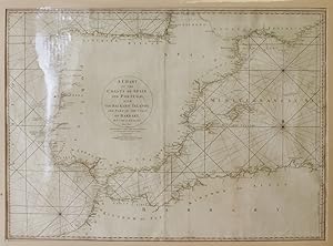
A Chart of the Coasts of Spain and Portugal with the Balearic Islands and Part of the Coast of Barbary
Verlag: Wm. Faden, Successor to the Late T. Jeffrys, Geogr. to the King, London, 1780
Anbieter: James Cummins Bookseller, ABAA, New York, NY, USA
Bewertung:

Zustand: Framed. Second edition. Second edition. Hand-colored in outline. 1 vols. 53 x 73 cm. Hand-colored in outline. 1 vols. 53 x 73 cm.
-
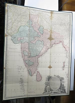
Hind, Hindoostan or India
Verlag: J. A. Wyld, London, 1832
Anbieter: Renaissance Books, ANZAAB / ILAB, Dunedin, Neuseeland
Bewertung:
Erstausgabe
Hardcover. Zustand: Good. Zustand des Schutzumschlags: No Dust Jacket. First Edition. Water staining and wrinkling to upper corners of case. Rubbing to corners of case. 1 1/2" tear in cloth to front left corner of case. Brown water marks to folds of map. 3" water stain to top left hand corner of map, another 3" water stain to top of map. 4" water stain to fold of map. ; Linen and card backed map in brown cloth case. Detailed map of India showing Tibet, Bhutan,The Maldives and Nicobar Islands. Map dimensions approx: 735mm x 567mm. ; 8vo 8" - 9" tall.
-
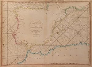
A Chart of the Coasts of Spain and Portugal, with the Balearic Islands, and part of the Coast of Barbary
Verlag: William Faden, London, 1780
Anbieter: William Chrisant & Sons, ABAA, ILAB. IOBA, ABA, Ephemera Society, Fort Lauderdale, FL, USA
Verbandsmitglied: ABAA ESA ILAB
Bewertung:
Map. Zustand: Very Good. Paper size: 552 x 741 mm. Image size: 512 x 708 mm. 18th century map in original hand-coloring. Minor foxing. Small tears to margins not affecting image. Page number to upper right corner of verso. Please see image. ; 552 x 741 mm; All shipments through USPS insured Priority Mail. .
-
51x88cm. Original outline colour. Excellent condition. Admiral of the Fleet Richard Howe, 1st Earl Howe KG (1726 99) was a British naval officer, best known for his command of the British fleet during the Glorious First of June in 1794, which is recorded in this specially extended edition of the chart.
-

The Coast of Guyana from the Oroonoko to the River of Amazons and Inland Parts as far as they have been Explored by the French & Dutch Engineers with the Islands of Barbados Tobago &ca.
Verlag: LondonW. Faden., 1783
Anbieter: Robert Frew Ltd. ABA ILAB, London, Vereinigtes Königreich
Verbandsmitglied: ABA ILAB PBFA
Bewertung:
Karte
(Sheet size: 59 x 80 cm). Double page map of the coast of Guyana with inset plans of the entrance of the River Beatrice, Surinam River, Port of Cayenne and part of the rivers Essequebo and Demerari. Also includes 'Remarks and Observations on the Coast of Guyana' and 'The Entrances of the Rivers Essequebo and Demerari' by Captain Thompson. Information on astronomical observations and geographical features is provided in tables and annotations. Original hand colour. Tear without loss at left hand margin. Edges worn with small tears. Some light offsetting, otherwise clean and bright.
-
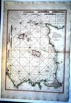
A Chart of the Islands of Jersey and Guernsey, Sark, Herm and Alderney: With the Adjacent Coast of France.
Verlag: No publisher William Faden London, 1781
Anbieter: Patrick Pollak Rare Books ABA ILAB, SOUTH BRENT, DEVON, Vereinigtes Königreich
Bewertung:

SHEET SIZE : c.83Ľ x 58˝ cms.; PLATE SIZE : c.72˝ x 53 cms. Hand-coloured boundaries -:- J. WHATMAN watermark -:- Printed number '10' on the reverse, the sheet number indicating origin in Faden's New General Atlas. Repaired in the centre fold with very slight loss, the sheet uncut.
-
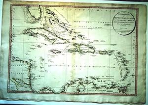
General Chart of the West India Islands with the Adjacent Coasts of the Spanish Continent.
Verlag: William. Faden. London. September 23rd, 1796
Anbieter: Patrick Pollak Rare Books ABA ILAB, SOUTH BRENT, DEVON, Vereinigtes Königreich
Bewertung:
SHEET SIZE : c.84˝ x 58 cms.; PLATE SIZE : c.78 x 53˝ cms. Hand-coloured boundaries -:- J. WHATMAN watermark -:- Printed number '51' on the reverse, the sheet number indicating origin in Faden's New General Atlas. Repaired in the centre fold and at the top edge, the sheet uncut.
-
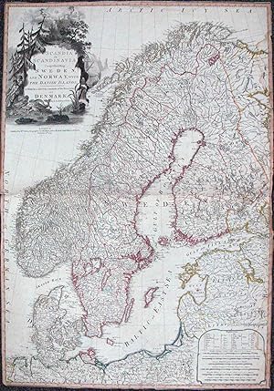
Scandia or Scandinavia Comprehending Sweden, and Norway with the Danish Islands
Verlag: London, London, 1794
Anbieter: High Ridge Books, Inc. - ABAA, South Deerfield, MA, USA
Verbandsmitglied: ABAA ESA ILAB SNEAB
Bewertung:
Trimmed close with small chips at right side and bottom left corner. Stunning map of Scandinavia by Louis Stanislas d'Arcy de la Rochette, which appeared in Faden's General Atlas. This early addition pre-dates the Napoleonic Wars and shows Norway and Denmark as unified and Finland as part of Sweden. The map reflects the art of map printing at one of its high points, employing high quality hand made paper, fine copperplate engraving and rich elengant hand coloring. The detail throughout the map is remarkable and is embellished with a decorative cartouche. the map shows towns, duchys, rivers, lakes, roads, bays, islands and a host of other important details. One of the most attractive 18th Century maps of Scandinavia. Published by William Faden. Roseberg p. 80; Mingroot p. 133.
-
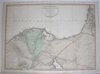
Lower Egypt and the Adjacent Deserts with part of Palestine
Verlag: William Faden, London, 1802
Anbieter: Alexandre Antique Prints, Maps & Books, Toronto, ON, Kanada
Bewertung:

Karte
Zustand: Very Good. Size : 560x770 (mm), 22x30.25 (Inches), Original Hand Coloring.
-
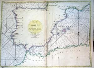
A chart of the Coasts of Spain and Portugal with the Balearic Islands and part of the Coast of Barbary
Verlag: Londres, 1780
Kunst / Grafik / Poster
Zustand: ACEPTABLE. 2d Edition EngravedandPublished.by W. Faden.June 28th 1780 Marca de doblez (3) Formato (cm): 72x53.
-
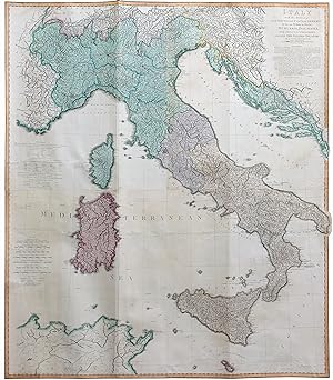
Italy with the addition of the Southern Parts of Germany as far as Pettau in Stiria; Murlakia, Dalmatia The adjacent countries, and all the Iliric Islands.
Verlag: William Faden, Londra, 1800
Anbieter: libreria antiquaria perini Sas di Perini, Verona, VR, Italien
Bewertung:
Kunst / Grafik / Poster
Incisione in rame, dipinta a mano, cm 125x108. Magnifica carta geografica di tutta l'Italia inquadrata da bordura, incisa finemente in rame su 4 fogli a colori coevi a pieno campo, stampata su carta forte. La mappa include oltre all'Italia, la Slovenia e la Penisola Balcanica. Sono segnate strade e itinerari postali. Scala delle miglia in basso a sinistra. Tratta da General Atlas di Faden. Ottimo esemplare. Nr.cat: Cod 6428.