
Gesamtpreis (1 Artikel Artikel):
Versandziel:

speede john (34 Ergebnisse)
Direkt zu den wichtigsten Suchergebnissen
Suchfilter
Produktart
- Alle Product Types
- Bücher (25)
- Magazine & Zeitschriften (Keine weiteren Ergebnisse entsprechen dieser Verfeinerung)
- Comics (Keine weiteren Ergebnisse entsprechen dieser Verfeinerung)
- Noten (Keine weiteren Ergebnisse entsprechen dieser Verfeinerung)
- Kunst, Grafik & Poster (Keine weiteren Ergebnisse entsprechen dieser Verfeinerung)
- Fotografien (Keine weiteren Ergebnisse entsprechen dieser Verfeinerung)
- Karten (9)
- Manuskripte & Papierantiquitäten (Keine weiteren Ergebnisse entsprechen dieser Verfeinerung)
Zustand Mehr dazu
- Neu (3)
- Wie Neu, Sehr Gut oder Gut Bis Sehr Gut (2)
- Gut oder Befriedigend (20)
- Ausreichend oder Schlecht (Keine weiteren Ergebnisse entsprechen dieser Verfeinerung)
- Wie beschrieben (9)
Einband
Weitere Eigenschaften
- Erstausgabe (2)
- Signiert (Keine weiteren Ergebnisse entsprechen dieser Verfeinerung)
- Schutzumschlag (Keine weiteren Ergebnisse entsprechen dieser Verfeinerung)
- Angebotsfoto (22)
- Keine Print-on-Demand Angebote (34)
Sprache (2)
Gratisversand
Land des Verkäufers
Verkäuferbewertung
-

Old Map of Yorkshire 1610. An Antiqued Parchment Replica.
Verlag: Penzance: Old Map Company, 1991
Anbieter: Plurabelle Books Ltd, Cambridge, Vereinigtes Königreich
Verbandsmitglied: GIAQ
Verkäuferbewertung 5 von 5 Sternen

EUR 5,90
EUR 9,17 Versand
Versand von Vereinigtes Königreich nach USAAnzahl: 1 verfügbar
In den WarenkorbPaperback. Zustand: Very Good. Foldout antiqued parchment replica map in original red card pouch, light wear to cover, map excellent, as new Language: English.
-
Old Map of Essex 1610. An Antiqued Parchment Replica.
Verlag: Penzance: Old Map Company, 1991
Anbieter: Plurabelle Books Ltd, Cambridge, Vereinigtes Königreich
Verbandsmitglied: GIAQ
Verkäuferbewertung 5 von 5 Sternen
EUR 5,90
EUR 9,17 Versand
Versand von Vereinigtes Königreich nach USAAnzahl: 1 verfügbar
In den WarenkorbPaperback. Zustand: Very Good. Foldout antiqued parchment replica map in original red card pouch, light wear to cover, map excellent, as new Language: English.
-
CANTERBURY TOWN PLAN 1610
Verlag: Olde Map Company, Penzance, Cornwall, 1991
Anbieter: Stephen Dadd, Ashford, Vereinigtes Königreich
Verkäuferbewertung 5 von 5 Sternen
EUR 5,32
EUR 14,84 Versand
Versand von Vereinigtes Königreich nach USAAnzahl: 1 verfügbar
In den WarenkorbMap. Zustand: Very Good. Antiqued parchment replica of John Speede's map of 1610. In original cardboard slipcase. Size: 8vo - over 7ľ - 9ľ" tall. Book.
-
OLD MAP OF YORKSHIRE (GENERAL MAP) 1610
Verlag: Olde Map Company, Penzance, Cornwall, 1991
Anbieter: Stephen Dadd, Ashford, Vereinigtes Königreich
Verkäuferbewertung 5 von 5 Sternen
EUR 5,32
EUR 14,84 Versand
Versand von Vereinigtes Königreich nach USAAnzahl: 1 verfügbar
In den WarenkorbMap. Zustand: Very Good. Antiqued parchment replica of John Speede's map of 1610. In original cardboard slipcase. Book.
-
Old Map of Shropshire of 1610, Parchment Replica
Verlag: The Olde Map Co, Penzance, 1111
Anbieter: Castle Hill Books, Llandrindod Wells, Vereinigtes Königreich
Verkäuferbewertung 4 von 5 Sternen

EUR 2,30
EUR 21,60 Versand
Versand von Vereinigtes Königreich nach USAAnzahl: 1 verfügbar
In den WarenkorbHardcover. Zustand: New. Antiqued parchment replica of Speeds' 1610 map Wales, in a card slipcase; 8vo 8" - 9" tall.
-
Old Map Wales of 1610, Parchment Replica
Verlag: The Olde Map Co, Penzance, 1111
Anbieter: Castle Hill Books, Llandrindod Wells, Vereinigtes Königreich
Verkäuferbewertung 4 von 5 Sternen
EUR 2,30
EUR 21,60 Versand
Versand von Vereinigtes Königreich nach USAAnzahl: 1 verfügbar
In den WarenkorbHardcover. Zustand: New. Antiqued parchment replica of Speeds' 1610 map Wales, in a card slipcase; 8vo 8" - 9" tall.
-
Old Map of Gloucestershire of 1610, Parchment Replica
Verlag: The Olde Map Co, Penzance, 1111
Anbieter: Castle Hill Books, Llandrindod Wells, Vereinigtes Königreich
Verkäuferbewertung 4 von 5 Sternen
EUR 2,30
EUR 21,60 Versand
Versand von Vereinigtes Königreich nach USAAnzahl: 1 verfügbar
In den WarenkorbHardcover. Zustand: New. Antiqued parchment replica of Speeds' 1610 map Wales, in a card slipcase; 8vo 8" - 9" tall.
-
Olde Map of Cornwall: An Antiqued Parchment Replica (The Olde Map Company)
Verlag: The Olde Map Company
Anbieter: Wonder Book, Frederick, MD, USA
Verkäuferbewertung 5 von 5 Sternen
Zustand: As New. Like New condition. Slipcase Very Good. (Cornwall, Great Britain, maps ) A near perfect copy that may have very minor cosmetic defects.
-

Map of the countie of Nottingham
Verlag: Unknown, 1985
Anbieter: Aucott & Thomas, Ibstock, Vereinigtes Königreich
Verkäuferbewertung 5 von 5 Sternen
Karte
EUR 11,33
EUR 17,19 Versand
Versand von Vereinigtes Königreich nach USAAnzahl: 1 verfügbar
In den WarenkorbMap. Zustand: Very Good. Reprint. Coloured reprint of John Speede's 1610 map. Map is 58.3 x 45.5cm, border is 3.5cm. No marks, chips or inscriptions. Undated but assume mid 1980s. Printed on very good quality cartridge paper, and will be sent in a cardboard tube to avoid postal damage.
-

Map of Suffolk(e)
Verlag: Unknown, 1985
Anbieter: Aucott & Thomas, Ibstock, Vereinigtes Königreich
Verkäuferbewertung 5 von 5 Sternen
Karte
EUR 11,33
EUR 17,19 Versand
Versand von Vereinigtes Königreich nach USAAnzahl: 1 verfügbar
In den WarenkorbMap. Zustand: Very Good. Reprint. Coloured reprint of John Speede's 1610 map. Map is 58.3 x 45.5cm, border is 3.5cm. Edge creased at bottom left corner, 2 small closed tears at bottom edge, no inscriptions. Undated but assume mid 1980s.
-

Map of Oxfordshire
Verlag: Unknown, 1985
Anbieter: Aucott & Thomas, Ibstock, Vereinigtes Königreich
Verkäuferbewertung 5 von 5 Sternen
Karte
EUR 11,33
EUR 17,19 Versand
Versand von Vereinigtes Königreich nach USAAnzahl: 1 verfügbar
In den WarenkorbMap. Zustand: Very Good. Reprint. Coloured reprint of John Speede's 1610 map. Map is 58.3 x 45.5cm, border is 3.5cm. Edge creased at bottom corners, 2 small closed tears on left edge & on bottom edge, no inscriptions. Undated but assume mid 1980s.
-

Map of Herefordshire
Verlag: Unknown, 1985
Anbieter: Aucott & Thomas, Ibstock, Vereinigtes Königreich
Verkäuferbewertung 5 von 5 Sternen
Karte
EUR 11,33
EUR 17,19 Versand
Versand von Vereinigtes Königreich nach USAAnzahl: 1 verfügbar
In den WarenkorbMap. Zustand: Very Good. Reprint. Coloured reprint of John Speede's 1610 map. Map is 58.3 x 45.5cm, border is 3.5cm. Lightly creased with short closed tear at top edge, no inscriptions. Undated but assume mid 1980s.
-

Map of Wilshire (Wiltshire)
Verlag: Unknown, 1985
Anbieter: Aucott & Thomas, Ibstock, Vereinigtes Königreich
Verkäuferbewertung 5 von 5 Sternen
Karte
EUR 11,33
EUR 17,19 Versand
Versand von Vereinigtes Königreich nach USAAnzahl: 1 verfügbar
In den WarenkorbMap. Zustand: Very Good. Reprint. Coloured reprint of John Speede's 1610 map. Map is 58.3 x 45.5cm, border is 3.5cm. No creases, chips or inscriptions. Undated but assume mid 1980s.
-

Map of Somerset-shire
Verlag: Unknown, 1985
Anbieter: Aucott & Thomas, Ibstock, Vereinigtes Königreich
Verkäuferbewertung 5 von 5 Sternen
Karte
EUR 11,33
EUR 17,19 Versand
Versand von Vereinigtes Königreich nach USAAnzahl: 1 verfügbar
In den WarenkorbMap. Zustand: Very Good. Reprint. Coloured reprint of John Speede's 1610 map. Map is 58.3 x 45.5cm, border is 3.5cm. Edges lightly creased and 2 small closed tears, one at each edge (will not show once framed), no inscriptions. Undated but assume mid 1980s. Printed on very good quality cartridge paper, and will be sent in a cardboard tube to avoid postal damage.
-

Map of Derbyshire (Darbieshire)
Verlag: Unknown, 1985
Anbieter: Aucott & Thomas, Ibstock, Vereinigtes Königreich
Verkäuferbewertung 5 von 5 Sternen
Karte
EUR 11,33
EUR 17,19 Versand
Versand von Vereinigtes Königreich nach USAAnzahl: 1 verfügbar
In den WarenkorbMap. Zustand: Very Good. Reprint. Coloured reprint of John Speede's 1610 map. Map is 58.3 x 45.5cm, border is 3.5cm. No marks, chips or inscriptions. Undated but assume mid 1980s. Printed on very good quality cartridge paper, and will be sent in a cardboard tube to avoid postal damage.
-

Old Map of London 1593: An Antiques Parchment Replica
Verlag: The Old Map Company, Great Britain, 1991
Anbieter: Leura Books, Bowral, NSW, Australien
Verkäuferbewertung 5 von 5 Sternen
Softcover. Zustand: Very Good. Beautiful reproduction of the John Speede map showing towns, villages and boundaries as they were in the reign of Queen Elizabeth l. Illustrated with heraldic detail and decoration. Quantity Available: 1. Shipped Weight: Under 500 grams. Category: History; History; History::Great Britain. Inventory No: 277643.
-

Old Map of Nottinghamshire 1610
Verlag: The Olde Map Co, Penzance, 1991
Anbieter: Lazy Letters Books, Market Rasen, Vereinigtes Königreich
Verkäuferbewertung 5 von 5 Sternen
EUR 4,72
EUR 25,21 Versand
Versand von Vereinigtes Königreich nach USAAnzahl: 1 verfügbar
In den WarenkorbMap. Zustand: Very Good. Antiqued parchment replica folded in card pocket.
-
Old Map of Warwickshire 1610
Verlag: Porter Prints, York
Anbieter: Anvil Books, Prestatyn, FLINT, Vereinigtes Königreich
Verkäuferbewertung 5 von 5 Sternen
EUR 5,90
EUR 27,50 Versand
Versand von Vereinigtes Königreich nach USAAnzahl: 1 verfügbar
In den WarenkorbMap. Zustand: Fine. No Jacket. Rep. 20 x 15 inches, folded as issued in sl worn envelope. Authentic replica on antiqued parchment.
-
Old Map of Shropshire 1610.
Verlag: Cornwall: The Olde Map Co, 1991., 1991
Anbieter: Salopian Books, Shrewsbury, SAL, Vereinigtes Königreich
Verbandsmitglied: IOBA
Verkäuferbewertung 5 von 5 Sternen
Karte
EUR 2,36
EUR 36,67 Versand
Versand von Vereinigtes Königreich nach USAAnzahl: 1 verfügbar
In den WarenkorbNo Binding. Zustand: Good. Replica 'antiqued parchment' fold-out map in good condition in card sleeve. Some general wear and marks to sleeve. 8vo.
-
[THE ISLANDS.BRITISH ISLES].Holy Island, Farne, Guernsey, Jersey.]
Sprache: Englisch
Verlag: Henry Overton, London, 1610
Anbieter: David Wright Private Collection, Lowestoft, SUFFO, Vereinigtes Königreich
Verkäuferbewertung 4 von 5 Sternen
Erstausgabe
EUR 76,72
EUR 37,47 Versand
Versand von Vereinigtes Königreich nach USAAnzahl: 1 verfügbar
In den WarenkorbUnbound. Zustand: Near Very Good. No Jacket. J. Hondius (illustrator). First Edition. Holy Iland, Garnsey, Farne, Jarsey. Performed by John Speede and are to be solde by Henry Overton at the White Horse without Newgate, London. J. Hondius, 1610. An original map with contemporary hand colouring, divided into 4 quadrants each depicting a named island. narrow black Hogarth frame measuring 63.5 x51 cms. The engraved surface measures 51 x 38 cms. and has a narrow cream card mount allowing visible margins of 2 cms. There is the stain of an old sellotape repair 1.5 cms long at the extreme tail edge of the centre fold and there is possibly some fading to the colouring. Being framed, it is not possible to establish if the text on the verso is in latin. There is no Humble imprint in this issue. RARE.
-

Olde Map of Durham 1610
Verlag: The Olde Map Company, 1991
Anbieter: Peter Pan books, Haltwhistle, Vereinigtes Königreich
Verkäuferbewertung 5 von 5 Sternen
EUR 5,90
EUR 40,11 Versand
Versand von Vereinigtes Königreich nach USAAnzahl: 1 verfügbar
In den WarenkorbNo Binding. Zustand: Very Good. Good condition 'antiqued parchment replica' [abeb].
-
OLD MAP OF LANCASHIRE 1610 - Antiqued Parchment Replica.
Verlag: The Old Map Company, 1991
Anbieter: Virginia Bank Books., ACLE, Norfolk, NOR, Vereinigtes Königreich
Verkäuferbewertung 4 von 5 Sternen
EUR 3,48
EUR 45,15 Versand
Versand von Vereinigtes Königreich nach USAAnzahl: 1 verfügbar
In den Warenkorb(10300) Antiqued Parchment Map of Speede's 1610 map of Lancashire in red card slipcase. Ex shop stock. As new.
-

The Kingdome of Irland - Divided into several Provinces, and the againe devided into Counties
Anbieter: Kennys Bookshop and Art Galleries Ltd., Galway, GY, Irland
Verkäuferbewertung 5 von 5 Sternen
Zustand: Very Good. . Hardback. "Extremely rare print. Few available. Reproduction of the famous John Speede map of Ireland from 1610. This was the earliest proper map of Ireland, and original copies are now scarce and very highly valued." Keywords: Posters - Ireland - Maps & Prints - Antique Maps. Not a first edition copy. . . .
-

The Kingdome of Irland - Divided into several Provinces, and the againe devided into Counties
Anbieter: Kennys Bookstore, Olney, MD, USA
Verkäuferbewertung 5 von 5 Sternen
Zustand: Very Good. . Hardback. "Extremely rare print. Few available. Reproduction of the famous John Speede map of Ireland from 1610. This was the earliest proper map of Ireland, and original copies are now scarce and very highly valued." Keywords: Posters - Ireland - Maps & Prints - Antique Maps. Not a first edition copy. . . . Books ship from the US and Ireland.
-
Northumberland - Published By Henry Overton
Sprache: Englisch
Verlag: Henry Overton, London, UK, 1710
Anbieter: Hornseys, Ripon, Vereinigtes Königreich
Verbandsmitglied: PBFA
Verkäuferbewertung 5 von 5 Sternen
EUR 584,29
EUR 28,65 Versand
Versand von Vereinigtes Königreich nach USAAnzahl: 1 verfügbar
In den WarenkorbNo Binding. Zustand: Very Good. Original copper-engraved map. Sheet size: 60.8cm x 48.7cm. Publishers show as Bassett and Chiswell but this is from an edition printed by Henry Overton in c.1710 or later. Blank to the verso as is found with the edition published by Henry Overton. Includes inset maps of Berwick and Newcastle. Good wide margins but with some age toning and browning which is mainly confined to the margins and the verso. Early hand-colouring. A scarce edition of John Speed's map of Northumberland and in very good condition overall.
-
?Miniature? Herefordshire. Original Antique Engraved Hand Coloured Miniature Map of Herefordshire.
Verlag: London, Sudbury & Humble, 1627, 1627
Anbieter: PROCTOR / THE ANTIQUE MAP & BOOKSHOP, DORCHESTER, Vereinigtes Königreich
Verbandsmitglied: PBFA
Verkäuferbewertung 5 von 5 Sternen
EUR 84,99
EUR 22,92 Versand
Versand von Vereinigtes Königreich nach USAAnzahl: 1 verfügbar
In den WarenkorbSo-called ?Miniature Speed.? Engraved surface approx 12 x 8 cm. Overall 15 x 9 cm. (approx 6 x 4 inches.) In very good condition. Nice bright colouring. Some minor darkening around edges. Bottom corner/edge of map is slightly clipped by page edge. Else an excellent clean and bright example. Original double-sided engraved map with later hand colouring, and part description of county on rear.
-
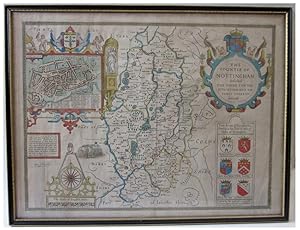
John Speede County Map SPEEDE'S NOTTINGHAM The Countie of Nottingham described The Shire Townes Situation and the Earls thereof observed
Verlag: London Performed by John Speede and to be sold by Thomas Bassett in Fleet Street & Richard Chiswell in St Pauls Church Yard, 1610
Anbieter: John L. Capes (Books) Established 1969, STAITHES, Vereinigtes Königreich
Verbandsmitglied: PBFA
Verkäuferbewertung 5 von 5 Sternen
EUR 324,60
EUR 30,94 Versand
Versand von Vereinigtes Königreich nach USAAnzahl: 1 verfügbar
In den WarenkorbThe Nottinghamshire county map, [ with inset plan of the town ] from Speed's "Theatre of the Empire" the first Atlas of the British Isles.The 1676 Bassett & Chiswell issue with nice early colouring and good margins double glazed with English text to the back.
-
Somerset shire Described
Verlag: London, 1610
Anbieter: Graver & Pen Rare Books, Midland, MI, USA
Verkäuferbewertung 5 von 5 Sternen
No Binding. Zustand: Good. No Jacket. Attractive hand coloring. Good. Creasing to middle, Japanese paper repair to various tears, yellowing to paper. Includes inset view of Bath (Bathe) and coats-of-arms in lower corners and sea colored blue with ships. From John Speedżs Theatre of the Empire of Great Britaine. Anno 1610 in lower corner, but a scarce reprint circa 1690 - 1695 by "Christopher Browne, at the Globe near the West End of St. Paul's Church London".
-
RUTLANDSHIRE With OUKHAM and STANFORD. Original Antique Engraved Hand Coloured Map of RUTLANDSHIRE. With, Arms of Nobles and County Crest. Plan of County Towns OUKHAM and STANFORD. Illustrations of Scribes to bottom corners.
Verlag: London, Sudbury & Humbell, 1620, 1620
Anbieter: PROCTOR / THE ANTIQUE MAP & BOOKSHOP, DORCHESTER, Vereinigtes Königreich
Verbandsmitglied: PBFA
Verkäuferbewertung 5 von 5 Sternen
EUR 389,53
EUR 22,92 Versand
Versand von Vereinigtes Königreich nach USAAnzahl: 1 verfügbar
In den WarenkorbPrinted area is approximately 50.6cms by 38.1cms. In very good condition. A minor crease on right hand margin, vertical center hold crease. Nice colouring. Some minor tanning, else A beautiful clean example. Ready to be Framed Original engraved map with hand colouring. A highly decorative 17th century map of Rutland, based on the survey by John Harrington, which was published in John Speed's Theatre of the Empire of Great Britaine (London: Sudbury & Humble, 1620s [No text]). The inset town plans of Stamford and Oakham, probably surveyed by Speed himself, are the earliest known of these places. This particular example comes from an unusual and undated atlas (probably 1620s).
-
Wight Island. First Edition of Speed's map of the Isle of Wight. Original Antique Engraved Hand Coloured Map of Wight Island. The Isle of Wight, with inset town plans of Southampton and Newport.
Verlag: London, Sudbury & Humbell, 1611-12, 1611
Anbieter: PROCTOR / THE ANTIQUE MAP & BOOKSHOP, DORCHESTER, Vereinigtes Königreich
Verbandsmitglied: PBFA
Verkäuferbewertung 5 von 5 Sternen
EUR 501,66
EUR 22,92 Versand
Versand von Vereinigtes Königreich nach USAAnzahl: 1 verfügbar
In den WarenkorbPrinted area is approximately 52cms by 39cms. Held in Ivory mount, with one gilt line border. In good condition. Two old tape strips lower left corner, slightly creased & small nick lower right corner. A few very faint small brown spots. Ready to be Framed Original engraved map with Uncoloured. This map was engraved by Jodocus Hondius and published in the first edition of John Speed's important atlas, 'The Theatre of the Empire of Great Britain'.

![Bild des Verkäufers für [THE ISLANDS.BRITISH ISLES].Holy Island, Farne, Guernsey, Jersey.] zum Verkauf von David Wright Private Collection](https://pictures.abebooks.com/inventory/md/md32345888420.jpg)


