Gesamtpreis (1 Artikel Artikel):
Versandziel:

spruner karl theodor menke (15 Ergebnisse)
Direkt zu den wichtigsten Suchergebnissen
Produktart
- Alle Produktarten
- Bücher (15)
- Magazine & Zeitschriften
- Comics
- Noten
- Kunst, Grafik & Poster
- Fotografien
- Karten
-
Manuskripte &
Papierantiquitäten
Zustand
- Alle
- Neu
- Antiquarisch/Gebraucht
Einband
- alle Einbände
- Hardcover (5)
- Softcover
Weitere Eigenschaften
- Erstausgabe
- Signiert
- Schutzumschlag
- Angebotsfoto (11)
- Kein Print-on-Demand
Land des Verkäufers
Verkäuferbewertung
-

Gotha, Justus Perthes, o. J. (ca. 1880), SS. 13 - 16 (Italien), SS. 29 - 32 (Frankreich), mit 8 doppelblattgroßen Farbkarten (kolorierte Kupferstiche) zu Italien (Nr. 21 - 28) und 7 doppelblattgroßen Farbkarten zu Frankreich (Nr. 51 - 57), 2°, Leinwand mit Goldprägung, Einbandecken stark bestoßen bzw. mit aufgeplatzter Leinwand, am Buchrücken fehlt die obere Leinwandschicht komplett (Klebehaftung des Buchblocks jedoch noch intakt), Einband auch etwas berieben, Bleistift-Vermerke auf Vorsatz, ohne Titelblatt, da Band nur die für Frankreich und Italien relevanten Text- und Bildteile enthält (diese aber vollständig), Vorsätze leicht gebräunt, Blätter am Rand leicht gebräunt, Kartenrückseiten teils auch etwas stärker gebräunt , 1100 gr.
-
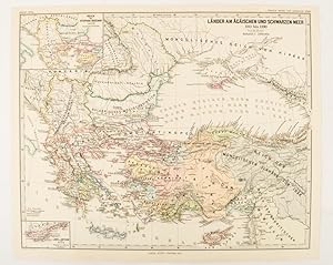
Länder am Ägäischen und Schwarzen Meer 1311 bis 1390.
Verlag: Justus Perthes, Gotha, 1877
Anbieter: Asia Bookroom ANZAAB/ILAB, Canberra, ACT, Australien
Bewertung:

Map with original colour and outline hand-colour, 32.2 x 40 cm, two inset maps, text in German, central fold, in very good condition. A most handsome map detailing countries on the Aegean and Black Seas 1311 to 1390. The inset maps depict the kingdom of Stephan Duschan (Serbia) and the land of the Crimean Goths, issued for the "Hand-Atlas für die Geschichte des Mittelatters und die Neueren Zeit".
-
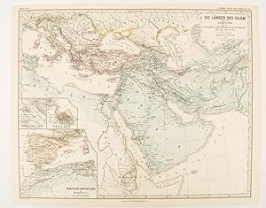
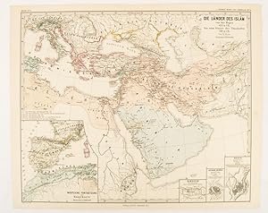
Die Länder des Islâm unter den Abbâsiden bis zur Einnahme von Baghdâd durch die Bűjiden 750 bis 945 n. Ch
Verlag: Justus Perthes, Gotha, 1877
Anbieter: Asia Bookroom ANZAAB/ILAB, Canberra, ACT, Australien
Bewertung:
Map with original colour and outline hand-colour, 32.2 x 40 cm, three inset maps, text in German, central fold, slight marginal toning, in very good condition. A most handsome map detailing the lands of Islam under the Abbasids up to the capture of Baghdâd by the Bűjids from 750 to 945 AD. The inset maps depict Northern Iraq, Baghdad, and a western continuation of the main map, issued for the "Hand-Atlas für die Geschichte des Mittelatters und die Neueren Zeit".
-
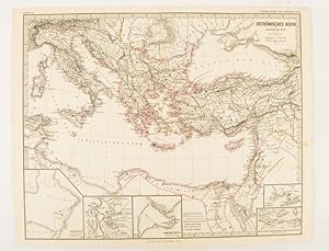
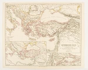
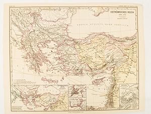
Oströmisches Reich zu Justinians Zeit.
Verlag: Justus Perthes., Gotha.
Anbieter: Asia Bookroom ANZAAB/ILAB, Canberra, ACT, Australien
Bewertung:
Map with original colour and outline hand-colour, 32.2 x 40 cm, text in German, five inset maps, central fold, slight marginal toning, and spotting on the verso, but in very good condition. A most handsome and highly detailed map detailing the Eastern provinces of the Byzantine/Roman Empire in the time of the Roman Emperor Justinian 527-565. The inset maps depict Carthage, Rome, Constantinople, Naples, and a Western continuation of the main map, originally issued for the "Hand-Atlas für die Geschichte des Mittelatters und die Neueren Zeit".
-
Oströmisches Reich von der Einwanderung der Ungarn in Ponnonien um 895 bis zur Unterwerfung des Bulgarenreichs durch Kaiser Basilius im J. 1019.
Verlag: Justus Perthes, Gotha, 1874
Anbieter: Asia Bookroom ANZAAB/ILAB, Canberra, ACT, Australien
Bewertung:
Map with original colour and outline hand-colour, 32.2 x 40 cm, three inset maps, text in German, central fold, slight marginal toning, in very good condition. A most handsome map detailing the Eastern Roman Empire from the immigration of Hungarians in Ponnonia around 895 to the subjugation of the Bulgarian Empire by Emperor Basilius in 1019. The inset maps depict Divisions of the Empire, Palestine, and the Themata around Propontis (present day Sea of Marmara), issued for the "Hand-Atlas für die Geschichte des Mittelatters und die Neueren Zeit".
-
Die Länder des Islâm von der Hegra 622 n. Ch. bis zum Sturze der Umaijaden 750 n. Ch.
Verlag: Justus Perthes, Gotha, 1877
Anbieter: Asia Bookroom ANZAAB/ILAB, Canberra, ACT, Australien
Bewertung:
Map with original colour and outline hand-colour, 33.1 x 40.2 cm, four inset maps, text in German, central fold, slight marginal edge wear and spotting to the verso, but in very good condition. A handsome map detailing the lands of Islam from Hegra in AD 622 to the fall of the Umayyads in AD 750. The inset maps depict a western extension to the main map and city plans for Damascus, Jathrib & Medina, and Mecca, issued for the "Hand-Atlas für die Geschichte des Mittelatters und die Neueren Zeit".
-
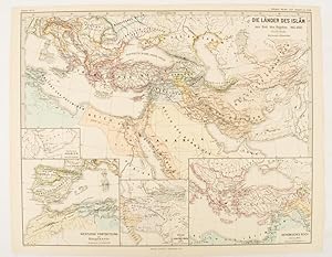
Die Länder des Islâm zur Zeit der Bűjiden 945-1055.
Verlag: Justus Perthes, Gotha, 1877
Anbieter: Asia Bookroom ANZAAB/ILAB, Canberra, ACT, Australien
Bewertung:
Map with original colour and outline hand-colour, 32.7 x 40.7 cm, four inset maps, text in German, central fold, slight marginal edge wear and spotting to the verso, but in very good condition. A handsome map detailing the lands of Islam at the time of the Bujids 945-1055. The inset maps depict a western extension to the main map, southern Arabia, the lands of the Ghaznavid sultanate in Central Asia, and lands of the Eastern Roman/Byzantine Empire, issued for the "Hand-Atlas für die Geschichte des Mittelatters und die Neueren Zeit".
-
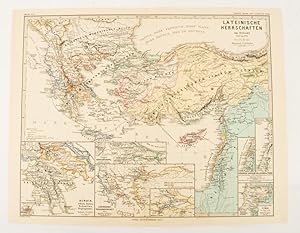
Lateinische Herrschaften im Orient 1210 bis 1311
Verlag: Justus Perthes, Gotha, 1876
Anbieter: Asia Bookroom ANZAAB/ILAB, Canberra, ACT, Australien
Bewertung:
Map with original colour and outline hand-colour, 32.2 x 40 cm, seven inset maps, text in German, central fold, slight marginal toning, in very good condition. A most handsome and highly detailed map detailing provinces of the Latin Empire in the wake of the Crusades. The inset maps depict Achaia in Greece, Divisions of the Empire, and a city plan of Constantinople, issued for the "Hand-Atlas für die Geschichte des Mittelatters und die Neueren Zeit".
-
Oströmisches Reich 1096-1204
Verlag: Justus Perthes, Gotha, 1876
Anbieter: Asia Bookroom ANZAAB/ILAB, Canberra, ACT, Australien
Bewertung:
Map with original colour and outline hand-colour, 32.2 x 40 cm, text in German, four inset maps, central fold, slight marginal toning, and spotting on the verso, but in very good condition. A most handsome and highly detailed map detailing the Eastern provinces of the Byzantine/Roman Empire before the Fourth Crusade. The inset maps depict Constantinople, Divisions of the Empire, and Antioch, issued for the "Hand-Atlas für die Geschichte des Mittelatters und die Neueren Zeit".
-
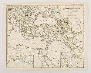
Osmanisches Reich und Seine Schutzstaaten.
Verlag: Justus Perthes (1880.), Gotha, 1880
Anbieter: Asia Bookroom ANZAAB/ILAB, Canberra, ACT, Australien
Bewertung:
Map with original outline hand-colour, 35.4 x 44 cm (sheet), two inset maps showing Ottoman ruled states in North Africa, and the Arabian Gulf; central fold, some offsetting and browning, but the map in very good condition. Text in German. Historic map showing the extent of the Ottoman Empire in the 17th Century. Prepared as map 90 from the Spruner-Menke Handatlas.
-
Atlas Antiquus. Karoli Spruneri Opus, tertio edidit Theodorus Menke (3. Auflage).
Verlag: Perthes, Gotha,, 1865
Anbieter: Antiquariat Winfried Scholl (VDA/ILAB), Osnabrück, Deutschland
Bewertung:

Folio. Doppelblattgroßer Titel, 17 S., 31 doppelblattgroße Kartentafeln mit Grenzkolorit. Halbleder der Zeit mit goldgeprägtem Rückentitel. Einband beschabt, Rückenbezug am Fuß lädiert. Alter Besitzvermerk auf Vorsatz. Textteil leicht gebräunt, wenige Karten fleckig oder im Seitenfuß mit kurzem Einriss im Falz. Insgesamt recht ordentlicher Zustand. Beide Abteilungen in einem Band.
-
Atlas Antiquus. Karoli Spruneri Opus, tertio edidit Theodorus Menke. 3. Auflage.
Verlag: Gotha Perthes, 1865
Anbieter: Antiquariat Uwe-Karsten Kramm, Stuttgart, Stuttgart, BW, Deutschland
Bewertung:

Gr.-4°. Doppelblatt-Titel, 13 nnr. Blätter, 31 Doppelblattgr. Karten. Schlichter Halbleineneinband der Zeit. Etwas berieben und bestoßen. Rücken mit kleinen Fehlstellen im Leinen. Karten stellenweise etwas gebräunt, aber sauber und unbeschädigt. *Zwei Abteilungen in 8 Lieferungen. 31 grenzkolorierte gestochene Karten. Sprache: Deutsch 3000 gr.
-
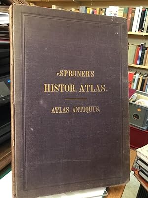
Atlas Antiquus. Karoli Spruneri Opus.
Verlag: Gotha: Perthes,, 1865
Anbieter: Altstadt-Antiquariat Nowicki-Hecht UG, Leer, NDS, Deutschland
Verbandsmitglied: GIAQ
Bewertung:
Buch
Zustand: Gut. Tertio editit Theodor Menke;. 17 S. Erläuterungen zu den folgenden 31 doppelseitigen farbigen Karten; Dritte (3.) Ausgabe / Auflage; Einband berieben und bestoßen, kl. Fehlstellen an d. Kapitalen, im Block sehr guter Zustand. (Schlagwörter: Atlas, Kartenwerk, Geschichtsatlas) /atlas Sprache: Deutsch Gewicht in Gramm: 2100 2°; gebunden, Orig.-Leinen mit Goldprägung;
-
Spruner-Menke Hand-Atlas für die Geschichte des Mittelalters und der neueren Zeit,
Verlag: Gotha, Justus Perthes, 1880
Buch
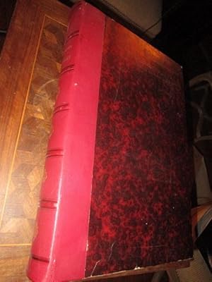
Couverture rigide. Zustand: Bon. 3čme Édition. 3. Auflage, Roter Halb Leder Einband der Zeit, fest, Titel mit Bünden am Rücken, sehr guter Zustand, nur an Kanten leicht berieben; schöne marmorierte Vorsätze; 90 colorierte Karten in Kupferstich mit 376 Nebenkarten, 42 Seiten, Schönes Exemplar ohne Benutzungspuren. Die Karten sind datiert von 1871 bis 1879, alle gut erhalten und ohne Flecken; Gewicht um 5 kg.; sehr gut erhaltenes ex.
-
Spruner-Menke Hand-Atlas für die Geschichte des Mittelalters und der neueren Zeit
Verlag: Justus Perthes Verlag Gotha 1880, 1880
Anbieter: Andrew Barnes Books / Military Melbourne, Melbourne, VIC, Australien
Bewertung:
3rd edition 3/4 leather Nice copy folio 42pp., colour maps, With 90 double-page colour maps. Beautifully bound by Peter Zerber in 3/4 burgundy leather over royal blue linen boards. Five raised bands at spine with a black leather title label.