Walling and gray (34 Ergebnisse)

Verlag: Walling and Grey, 1871
- Karte
Anbieter: Lule A Vavra Rare Maps and Books, Chester, VA, USALule A Vavra Rare Maps and Books
Verkäufer/-in kontaktierenVerkäufer/-in mit 4 SternenZustand: Gebraucht - Gut
EUR 40,54
Versand nach gratisVersand innerhalb von USAAnzahl: 1 verfügbar
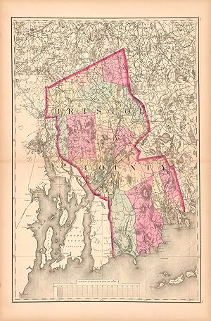
No Binding. Zustand: Very Good. ASSACHUSETTS - BRISTOL COUNTY - 1871. ----TITLE: Bristol County. ----BACKGROUND: Bristol County was created by the Plymouth Colony on June 2, 1685, but through the years areas were annexed or carved out to create the configuration shown. The larger towns of Fall River, New Bedford, and Taunton (th…e county seat) are shown. Townships are separately colored. Part of Rhode Island is on the left. ----PUBLICATION DETAILS: 22" h x 15"w. Bristol County is in original wash color; the remainder of the map is uncolored. From Walling & Gray, Official Topographical Atlas of Massachusetts (Boston: Stedman, Brown & Lyon, 1871). Walling & Gray also authored atlases of Pennsylvania s in 1871 and Ohio in 1872. ----PUBLISHERS: Henry Francis Walling was a cartographer born in Rhode Island in 1825 and died in Massachusetts in 1888. He was well prepared to publish maps and atlases. He had studied mathematics and surveying. He worked in the office of Barrett Cushing, a civil engineer in Providence. He began topographic work in 1849 preparing atlases containing maps and scientific descriptions of most of the northern states and the Dominion of Canada. He worked with h the geodetic survey of Massachusetts on the preparation of the state maps. He was a fellow of the American association for the advancement of science, and of the American Society of Civil Engineers. ----Ormando Willis Gray was born in Vermont in 1829 and died in Massachusetts in 1912. He was a civil and topographical engineer who produced maps and atlases, both as the publisher and with Walling. In 1869, he lived in Danielsonville, Connecticut. During the 1870s, he was in Philadelphia. Frank A. Gray was evidently O. W. Gray's son. They were partners in the publishing business O.W. Gray & Son in the 1870s and 1880s. ----CONDITION: Short centerfield separations have been mended with archival tape on the verso; otherwise the image is very good. ----N7205.

Verlag: The Bookmark, Knightstown, IN, 1977
- Softcover
Anbieter: Riverow Bookshop, Owego, NY, USARiverow Bookshop
Verkäufer/-in kontaktierenVerkäufer/-in mit 5 SternenZustand: Gebraucht
EUR 58,56
EUR 5,69 VersandVersand innerhalb von USAAnzahl: 1 verfügbar
Wraps. Zustand: G/NO DUSTJACKET. Reprint. Knightstown, IN: The Bookmark. G/NO DUSTJACKET. 1977. Reprint. Wraps. Atlas Folio, 146 pp., cover rubbed & frayed . Black & White Illustrations (illustrator).
Anbieter: Art Source International Inc., Boulder, CO, USAArt Source International Inc.
Verkäufer/-in kontaktierenVerkäufer/-in mit 5 SternenZustand: Gebraucht
EUR 31,53
EUR 13,99 VersandVersand innerhalb von USAAnzahl: 3 verfügbar
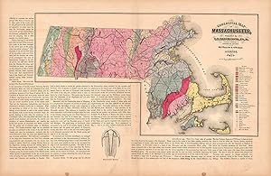
This hand colored map is from Walling and Grays Official Topographical Atlas of Massachusetts from Astronomical, Trigonometrical, and Various Local Surveys published in 1871. This map shows the geological features of Massachusetts- the mineral and the lithological group it is from are identified by color from a key on the map. S…urrounding the map is text explaining the research on the states geological features and the information illustrated in the map. This map measures 24 inches by 14.75 inches.
Anbieter: Art Source International Inc., Boulder, CO, USAArt Source International Inc.
Verkäufer/-in kontaktierenVerkäufer/-in mit 5 SternenZustand: Gebraucht
EUR 36,04
EUR 13,99 VersandVersand innerhalb von USAAnzahl: 3 verfügbar
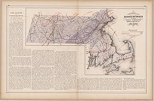
This hand colored map is from Walling and Grays Official Topographical Atlas of Massachusetts from Astronomical, Trigonometrical, and Various Local Surveys published in 1871. This climatological map illustrates the average temperature and rain fall in Massachusetts for the Summer, Winter and year in full. Details include countie…s, important cities and rail lines. The surrounding text describes the climate and expands on the information provided in the map. This map measures 23.5 inches by 14.5 inches.
Verlag: Philadelphia, 1872
Anbieter: Between the Covers-Rare Books, Inc. ABAA, Gloucester City, NJ, USABetween the Covers-Rare Books, Inc. ABAA
Verkäufer/-in kontaktierenVerkäufer/-in mit 5 SternenZustand: Gebraucht - Gut bis sehr gut
EUR 67,57
EUR 4,81 VersandVersand innerhalb von USAAnzahl: 1 verfügbar
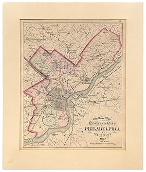
Unbound. Zustand: Near Fine. A 14.75" x 12" map matted to a larger frame unexamined outside of the mat. Slight age-toning else near fine in shrink wrap. A map removed from the *Topographical Atlas of the State of Pennsylvania* by Henry F. Walling and O.W. Gray considered the "first real atlas of the state." Walling was associate…d with Layfette College at the time and was the primary editor of the book while Gray, a Philadelphia civil engineer, provided the maps.
Anbieter: Art Source International Inc., Boulder, CO, USAArt Source International Inc.
Verkäufer/-in kontaktierenVerkäufer/-in mit 5 SternenZustand: Gebraucht
EUR 40,54
EUR 13,99 VersandVersand innerhalb von USAAnzahl: 3 verfügbar
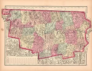
This hand colored map is from Walling and Grays Official Topographical Atlas of Massachusetts from Astronomical, Trigonometrical, and Various Local Surveys published in 1871. This bright pastel map is of Franklin County. Details include rail lines, the names of important cities, major roads, lakes and rivers.Important land owner…s and businesses are also identified. This map measures 17 inches by 10.5 inches.

Anbieter: Art Source International Inc., Boulder, CO, USAArt Source International Inc.
Verkäufer/-in kontaktierenVerkäufer/-in mit 5 SternenZustand: Gebraucht
EUR 40,54
EUR 13,99 VersandVersand innerhalb von USAAnzahl: 3 verfügbar
This hand colored map is from Walling and Grays Official Topographical Atlas of Massachusetts from Astronomical, Trigonometrical, and Various Local Surveys," published in 1871. This map of Worcester County is colored in vibrant pastels. Details include rail lines, county names, the names of important cities, major roads, lakes a…nd rivers. This map measures 17 inches by 23 inches.
Anbieter: Art Source International Inc., Boulder, CO, USAArt Source International Inc.
Verkäufer/-in kontaktierenVerkäufer/-in mit 5 SternenZustand: Gebraucht
EUR 40,54
EUR 13,99 VersandVersand innerhalb von USAAnzahl: 3 verfügbar
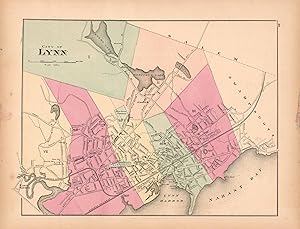
This hand colored map is from Walling and Grays Official Topographical Atlas of Massachusetts from Astronomical, Trigonometrical, and Various Local Surveys published in 1871. This bright pastel map of the City of Lynn and its surrounding areas illustrates the street plan of the area. Details include rail lines, the names of neig…hborhoods, rail lines, lakes and rivers as well as important buildings. This map measures 14.5 inches by 11 inches.
Verlag: Stedman, Brown and Lyon, Philadelphia, PA, 1872
- Hardcover
- Erstausgabe
Anbieter: Saucony Book Shop, Kutztown, PA, USASaucony Book Shop
Verkäufer/-in kontaktierenVerkäufer/-in mit 5 SternenZustand: Gebraucht - Gut
EUR 540,54
EUR 5,25 VersandVersand innerhalb von USAAnzahl: 1 verfügbar
Hardcover. Zustand: Very Good. 1st Edition. Burgundy-brown 1/2 leather, brown cloth, lettered in gilt, decorated in blind, marbled endpapers and text block edges. Cover cloth mildly faded/tanned toward edges, with a small section of dampstaing along front cover fore-edge, leather rubbed along joints and showing minor exposure at… corners. Back cover cloth is dampstained along most of fore-edge and bottom edge. Firm binding, with dampstaining showing up only slightly along bottom edges of a few latter leaves. 39 pp. text + 82 maps (12 city, 66 county, 6 general maps including double-page map of U.S.). Size: Elephant Folio - over 15" - 23" tall. Book.
Anbieter: Art Source International Inc., Boulder, CO, USAArt Source International Inc.
Verkäufer/-in kontaktierenVerkäufer/-in mit 5 SternenZustand: Gebraucht
EUR 49,55
EUR 13,99 VersandVersand innerhalb von USAAnzahl: 3 verfügbar
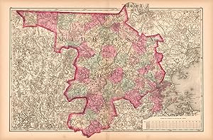
This hand colored map is from Walling and Grays Official Topographical Atlas of Massachusetts from Astronomical, Trigonometrical, and Various Local Surveys published in 1871. This bright pastel detailed map of Middlesex County includes rail lines,lakes and rivers- as well as important buildings. This map measures 23.25 inches by… 17 inches.
Anbieter: Art Source International Inc., Boulder, CO, USAArt Source International Inc.
Verkäufer/-in kontaktierenVerkäufer/-in mit 5 SternenZustand: Gebraucht
EUR 49,55
EUR 13,99 VersandVersand innerhalb von USAAnzahl: 3 verfügbar
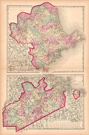
This hand colored map is from Walling and Grays Official Topographical Atlas of Massachusetts from Astronomical, Trigonometrical, and Various Local Surveys published in 1871. This bright pastel detailed map of Essex and Norfolk counties includes rail lines,lakes and rivers, as well as important buildings. This map measures 16.5…inches by 25 inches.
Anbieter: Art Source International Inc., Boulder, CO, USAArt Source International Inc.
Verkäufer/-in kontaktierenVerkäufer/-in mit 5 SternenZustand: Gebraucht
EUR 54,05
EUR 13,99 VersandVersand innerhalb von USAAnzahl: 3 verfügbar
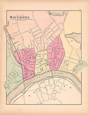
This hand colored map is from Walling and Grays Official Topographical Atlas of Massachusetts from Astronomical, Trigonometrical, and Various Local Surveys published in 1871. This bright pastel map of Haverhill and its surrounding areas illustrates the street plan of the area. Details include rail lines, the names of neighborhoo…ds, rail lines,lakes and rivers as well as important buildings. This map measures 11 inches by 14 inches.
Anbieter: Art Source International Inc., Boulder, CO, USAArt Source International Inc.
Verkäufer/-in kontaktierenVerkäufer/-in mit 5 SternenZustand: Gebraucht
EUR 58,56
EUR 13,99 VersandVersand innerhalb von USAAnzahl: 2 verfügbar
This hand colored map is from Walling and Grays Official Topographical Atlas of Massachusetts from Astronomical, Trigonometrical, and Various Local Surveys published in 1871. This bright pastel detailed map of Essex and Norfolk counties includes rail lines,lakes and rivers, as well as important buildings.Swamp land and hills are… indicated. This map measures 14.5 inches by 23 inches.
Anbieter: Art Source International Inc., Boulder, CO, USAArt Source International Inc.
Verkäufer/-in kontaktierenVerkäufer/-in mit 5 SternenZustand: Gebraucht
EUR 58,56
EUR 13,99 VersandVersand innerhalb von USAAnzahl: 3 verfügbar
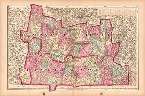
This hand colored map is from Walling and Grays Official Topographical Atlas of Massachusetts from Astronomical, Trigonometrical, and Various Local Surveys published in 1871. This map is of Hampshire and Hampden Counties colored in vibrant pastels. Details include rail lines, county names, the names of important cities, major ro…ads, lakes and rivers. This map measures 22.75 inches by 16 inches.
Anbieter: Art Source International Inc., Boulder, CO, USAArt Source International Inc.
Verkäufer/-in kontaktierenVerkäufer/-in mit 5 SternenZustand: Gebraucht
EUR 58,56
EUR 13,99 VersandVersand innerhalb von USAAnzahl: 3 verfügbar
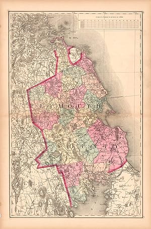
This hand colored map is from Walling and Grays Official Topographical Atlas of Massachusetts from Astronomical, Trigonometrical, and Various Local Surveys, published in 1871. This map is of Bristol County colored in vibrant pastels. Details include rail lines, county names, the names of important cities, major roads, lakes and…rivers. This map measures 15 inches by 23 inches.
Anbieter: Art Source International Inc., Boulder, CO, USAArt Source International Inc.
Verkäufer/-in kontaktierenVerkäufer/-in mit 5 SternenZustand: Gebraucht
EUR 67,57
EUR 13,99 VersandVersand innerhalb von USAAnzahl: 3 verfügbar
This hand colored map is from Walling and Grays Official Topographical Atlas of Massachusetts from Astronomical, Trigonometrical, and Various Local Surveys published in 1871. This map is of rail lines throughout Massachusetts and shows details including county and important city names, current and planned rail lines. A chart is…included listing the branches (origination and destination) and their lenghths. This map measures 24 inches by 14.75 inches.
Anbieter: Art Source International Inc., Boulder, CO, USAArt Source International Inc.
Verkäufer/-in kontaktierenVerkäufer/-in mit 5 SternenZustand: Gebraucht
EUR 67,57
EUR 13,99 VersandVersand innerhalb von USAAnzahl: 3 verfügbar
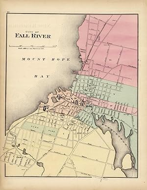
This hand colored map is from Walling and Grays Official Topographical Atlas of Massachusetts from Astronomical, Trigonometrical, and Various Local Surveys published in 1871. This bright pastel map of Fall River and its surrounding areas illustrates the street plan of the area. Details include rail lines, the names of neighborho…ods, rail lines, lakes and rivers as well as important buildings. This map measures 11.5 inches by 14 inches.
Anbieter: Art Source International Inc., Boulder, CO, USAArt Source International Inc.
Verkäufer/-in kontaktierenVerkäufer/-in mit 5 SternenZustand: Gebraucht
EUR 67,57
EUR 13,99 VersandVersand innerhalb von USAAnzahl: 3 verfügbar
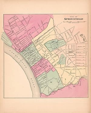
This hand colored map is from Walling and Grays Official Topographical Atlas of Massachusetts from Astronomical, Trigonometrical, and Various Local Surveys published in 1871. This bright pastel map of the City of Springfield and its surrounding areas illustrates the street plan of the area. Details include rail lines, the names…of neighborhoods,rail lines,lakes and rivers as well as important buildings. This map measures 11.75 inches by 12 inches.
Anbieter: Art Source International Inc., Boulder, CO, USAArt Source International Inc.
Verkäufer/-in kontaktierenVerkäufer/-in mit 5 SternenZustand: Gebraucht
EUR 67,57
EUR 13,99 VersandVersand innerhalb von USAAnzahl: 3 verfügbar
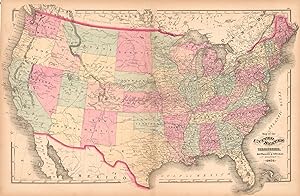
This hand colored map is from Walling and Grays Official Topographical Atlas of Massachusetts from Astronomical, Trigonometrical, and Various Local Surveys published in 1871. This bright pastel United States map illustrated the process of developement of the country by the obvious concentration of cities and rail lines to the ea…stern side. Details include rail lines, the names of important cities,rail lines,lakes and rivers. This map measures 25.5 inches by 17 inches.
Anbieter: Art Source International Inc., Boulder, CO, USAArt Source International Inc.
Verkäufer/-in kontaktierenVerkäufer/-in mit 5 SternenZustand: Gebraucht
EUR 76,58
EUR 13,99 VersandVersand innerhalb von USAAnzahl: 1 verfügbar
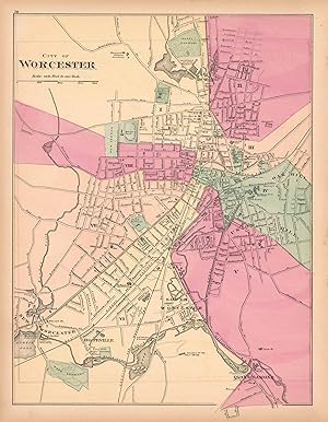
This hand colored map is from Walling and Grays Official Topographical Atlas of Massachusetts from Astronomical, Trigonometrical, and Various Local Surveys published in 1871. This bright pastel map of the City of Worcester and its surrounding areas illustrates the street plan of the area. Details include rail lines, the names of… neighborhoods,rail lines,lakes and rivers as well as important buildings. This map measures 12 inches by 15.5 inches.
Anbieter: Art Source International Inc., Boulder, CO, USAArt Source International Inc.
Verkäufer/-in kontaktierenVerkäufer/-in mit 5 SternenZustand: Gebraucht
EUR 85,59
EUR 13,99 VersandVersand innerhalb von USAAnzahl: 3 verfügbar
This hand colored map is from Walling and Grays Official Topographical Atlas of Massachusetts from Astronomical, Trigonometrical, and Various Local Surveys published in 1871. This map measures 15.5 inches by 12.5 inches.
Anbieter: Art Source International Inc., Boulder, CO, USAArt Source International Inc.
Verkäufer/-in kontaktierenVerkäufer/-in mit 5 SternenZustand: Gebraucht
EUR 85,59
EUR 13,99 VersandVersand innerhalb von USAAnzahl: 1 verfügbar
This hand colored map is from Walling and Grays Official Topographical Atlas of Massachusetts from Astronomical, Trigonometrical, and Various Local Surveys published in 1871. This map measures 20 inches by 17 inches.
Anbieter: Art Source International Inc., Boulder, CO, USAArt Source International Inc.
Verkäufer/-in kontaktierenVerkäufer/-in mit 5 SternenZustand: Gebraucht
EUR 85,59
EUR 13,99 VersandVersand innerhalb von USAAnzahl: 3 verfügbar
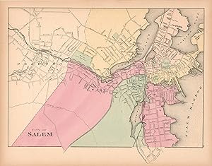
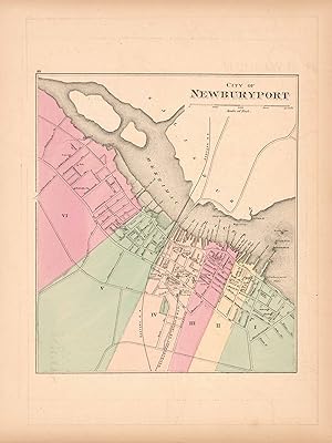
This hand colored map is from Walling and Grays Official Topographical Atlas of Massachusetts from Astronomical, Trigonometrical, and Various Local Surveys published in 1871. This bright pastel map of Newburyport and its surrounding areas illustrates the street plan of the area. Details include rail lines, the names of neighborh…oods,rail lines,lakes and rivers as well as important buildings. This map measures 10 inches by 11.25 inches.
Anbieter: Art Source International Inc., Boulder, CO, USAArt Source International Inc.
Verkäufer/-in kontaktierenVerkäufer/-in mit 5 SternenZustand: Gebraucht
EUR 85,59
EUR 13,99 VersandVersand innerhalb von USAAnzahl: 1 verfügbar
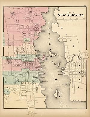
This hand colored map is from Walling and Grays Official Topographical Atlas of Massachusetts from Astronomical, Trigonometrical, and Various Local Surveys published in 1871. This bright pastel map of the city of New Bedford and its surrounding areas illustrates the street plan of the area. Details include rail lines, the names…of neighborhoods, rail lines, lakes and rivers as well as important buildings. This map measures 12 inches by 14.5 inches.
Anbieter: Art Source International Inc., Boulder, CO, USAArt Source International Inc.
Verkäufer/-in kontaktierenVerkäufer/-in mit 5 SternenZustand: Gebraucht
EUR 85,59
EUR 13,99 VersandVersand innerhalb von USAAnzahl: 2 verfügbar
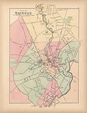
This hand-colored map is from Walling and Grays Official Topographical Atlas of Massachusetts from Astronomical, Trigonometrical, and Various Local Surveys published in 1871. This bright pastel map of the city of Taunton and its surrounding areas illustrates the street plan of the area. Details include rail lines, the names of n…eighborhoods, rail lines, lakes and rivers as well as important buildings. This map measures 10.5 inches by 15 inches.

Anbieter: Art Source International Inc., Boulder, CO, USAArt Source International Inc.
Verkäufer/-in kontaktierenVerkäufer/-in mit 5 SternenZustand: Gebraucht
EUR 90,09
EUR 13,99 VersandVersand innerhalb von USAAnzahl: 2 verfügbar
This hand colored map is from Walling and Grays Official Topographical Atlas of Massachusetts from Astronomical, Trigonometrical, and Various Local Surveys published in 1871. This bright pastel map of the City of Lawrence and its surrounding areas illustrates the street plan of the area. Details include rail lines, the names of…neighborhoods,rail lines,lakes and rivers as well as important buildings. This map measures 11.5 inches by 13.5 inches.
Anbieter: Art Source International Inc., Boulder, CO, USAArt Source International Inc.
Verkäufer/-in kontaktierenVerkäufer/-in mit 5 SternenZustand: Gebraucht
EUR 90,09
EUR 13,99 VersandVersand innerhalb von USAAnzahl: 2 verfügbar
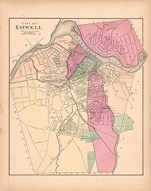
This hand colored map is from Walling and Grays Official Topographical Atlas of Massachusetts from Astronomical, Trigonometrical, and Various Local Surveys published in 1871. This bright pastel map of the City of Lowell and its surrounding areas illustrates the street plan of the area. Details include rail lines, the names of ne…ighborhoods,rail lines,lakes and rivers as well as important buildings. This map measures 14 inches by 12 inches.
Anbieter: Art Source International Inc., Boulder, CO, USAArt Source International Inc.
Verkäufer/-in kontaktierenVerkäufer/-in mit 5 SternenZustand: Gebraucht
EUR 94,60
EUR 13,99 VersandVersand innerhalb von USAAnzahl: 1 verfügbar
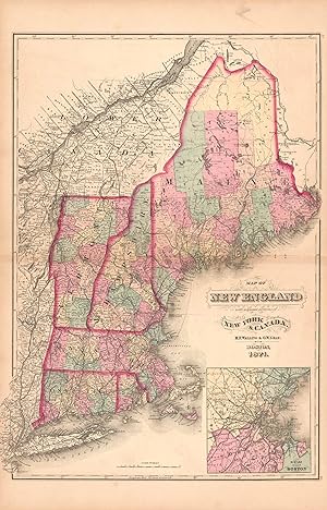
This hand colored map is from Walling and Grays Official Topographical Atlas of Massachusetts from Astronomical, Trigonometrical, and Various Local Surveys published in 1871. Details include rail lines, city and county names, and lakes and rivers. Also included is an inset of the city Boston and surrounding area. This map measur…es 16 inches by 22 inches.
Anbieter: Art Source International Inc., Boulder, CO, USAArt Source International Inc.
Verkäufer/-in kontaktierenVerkäufer/-in mit 5 SternenZustand: Gebraucht
EUR 94,60
EUR 13,99 VersandVersand innerhalb von USAAnzahl: 1 verfügbar
This hand colored map is from Walling and Grays Official Topographical Atlas of Massachusetts from Astronomical, Trigonometrical, and Various Local Surveys published in 1871. This map measures 25 inches by 16 inches.
Anbieter: Art Source International Inc., Boulder, CO, USAArt Source International Inc.
Verkäufer/-in kontaktierenVerkäufer/-in mit 5 SternenZustand: Gebraucht
EUR 99,10
EUR 13,99 VersandVersand innerhalb von USAAnzahl: 1 verfügbar
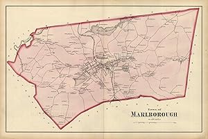
This hand-colored map is from Walling and Grays Official Topographical Atlas of Massachusetts from Astronomical, Trigonometrical, and Various Local Surveys published in 1871. This bright pastel map of the town of Marlborough and its surrounding areas illustrates the street plan of the area. Details include rail lines, the names…of neighborhoods, rail lines, lakes and rivers as well as important buildings. This map measures 24 inches by 15.5 inches.


