
Gesamtpreis (1 Artikel Artikel):
Versandziel:

carte isles java sumatra borneo von bellin nicolas (5 Ergebnisse)
Feedback
Direkt zu den wichtigsten Suchergebnissen
Suchfilter
Produktart
- Alle Product Types
- Bücher (1)
- Magazine & Zeitschriften (Keine weiteren Ergebnisse entsprechen dieser Verfeinerung)
- Comics (Keine weiteren Ergebnisse entsprechen dieser Verfeinerung)
- Noten (Keine weiteren Ergebnisse entsprechen dieser Verfeinerung)
- Kunst, Grafik & Poster (Keine weiteren Ergebnisse entsprechen dieser Verfeinerung)
- Fotografien (Keine weiteren Ergebnisse entsprechen dieser Verfeinerung)
- Karten (4)
- Manuskripte & Papierantiquitäten (Keine weiteren Ergebnisse entsprechen dieser Verfeinerung)
Zustand Mehr dazu
- Neu (Keine weiteren Ergebnisse entsprechen dieser Verfeinerung)
- Wie Neu, Sehr Gut oder Gut Bis Sehr Gut (1)
- Gut oder Befriedigend (2)
- Ausreichend oder Schlecht (Keine weiteren Ergebnisse entsprechen dieser Verfeinerung)
- Wie beschrieben (2)
Einband
- alle Einbände
- Hardcover (Keine weiteren Ergebnisse entsprechen dieser Verfeinerung)
- Softcover (Keine weiteren Ergebnisse entsprechen dieser Verfeinerung)
Weitere Eigenschaften
- Erstausgabe (1)
- Signiert (Keine weiteren Ergebnisse entsprechen dieser Verfeinerung)
- Schutzumschlag (Keine weiteren Ergebnisse entsprechen dieser Verfeinerung)
- Angebotsfoto (5)
- Keine Print-on-Demand Angebote (5)
Sprache (2)
Preis
- Beliebiger Preis
- Weniger als EUR 20 (Keine weiteren Ergebnisse entsprechen dieser Verfeinerung)
- EUR 20 bis EUR 40 (Keine weiteren Ergebnisse entsprechen dieser Verfeinerung)
- Mehr als EUR 40
Gratisversand
- Kostenloser Versand nach Deutschland (Keine weiteren Ergebnisse entsprechen dieser Verfeinerung)
Land des Verkäufers
Verkäuferbewertung
-

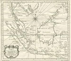
"Carte des Isles de Java, Sumatra, Borneo" - Borneo Java Malaysia Singapore Indonesia Indonesien Singapur Asia Asie Asien
Verlag: Paris, 1750
Sprache: Französisch
Anbieter: Antiquariat Steffen Völkel GmbH, Seubersdorf, Deutschland
Verkäuferbewertung 5 von 5 Sternen

Karte
EUR 69,99
Währung umrechnenEUR 6,50 für den Versand innerhalb von/der DeutschlandAnzahl: 1 verfügbar
In den WarenkorbOriginalKupferstich-Karte von Bellin von ca. 1750 - Blattmasse ca.27 x 32 cm - am linken Rand teils angerändert, nur leicht fleckig, sonst gut erhalten | original copper engraved map by Bellin from around 1750 - partly backed on the left margin, only slightly stained, otherwise in very good condition. Wir kaufen und verkaufen alte Bücher, Handschriften, Zeichnungen, Autographen, Grafiken und Fotografien. Wir sind stets am Ankauf von kompletten Bibliotheken, Sammlungen und Nachlässen interessiert. Sprache: Französisch Gewicht in Gramm: 10.
-

"Carte des Isles de Java, Sumatra, Borneo" - Borneo Java Malaysia Singapore Indonesia Indonesien Singapur Asia Asie Asien
Verlag: Paris, 1750
Sprache: Französisch
Anbieter: Antiquariat Steffen Völkel GmbH, Seubersdorf, Deutschland
Verkäuferbewertung 5 von 5 Sternen
Karte
EUR 69,99
Währung umrechnenEUR 6,50 für den Versand innerhalb von/der DeutschlandAnzahl: 1 verfügbar
In den WarenkorbOriginalKupferstich-Karte von Bellin von ca. 1750 - Blattmasse ca.27,5 x 33 cm - gut erhalten | original copper engraved map by Bellin from around 1750 - in very good condition. Wir kaufen und verkaufen alte Bücher, Handschriften, Zeichnungen, Autographen, Grafiken und Fotografien. Wir sind stets am Ankauf von kompletten Bibliotheken, Sammlungen und Nachlässen interessiert. Sprache: Französisch Gewicht in Gramm: 10.
-

Carte Des Isles de Java, Sumatra, Borneo & Les Detroits de la Sonde Malaca et Banca
Verlag: Bellini, 1760
Anbieter: Chaco 4ever Books, Montevideo, MO, Uruguay
Verkäuferbewertung 5 von 5 Sternen
Karte
EUR 262,11
Währung umrechnenEUR 26,72 für den Versand von Uruguay nach DeutschlandAnzahl: 1 verfügbar
In den WarenkorbSin Encuadernar. Zustand: Muy bien. Detailed map of the Malaysian peninsula, Borneo and Indonesia, from L'Histoire Generale des Voyages. With title cartouche at lower left and great detail on the Indonesian islands, including the names of cities and harbors. At bottom left corner "Tome II in 4, no. 2; at the lower right "Tome 4 in 8. Page 132". Uncolored, with compass rose.
-
Carte Des Isles de Java, Sumatra, Borneo & Les Detroits de la Sonde Malaca et Banca
Verlag: Chez Didot, Paris, 1760
Anbieter: Antipodean Books, Maps & Prints, ABAA, Garrison, NY, USA
Verbandsmitglied: ABAA ANZAAB ESA ILAB
Verkäuferbewertung 5 von 5 Sternen
Erstausgabe
EUR 360,84
Währung umrechnenEUR 30,32 für den Versand von USA nach DeutschlandAnzahl: 1 verfügbar
In den WarenkorbZustand: Very good condition. First printing. Detailed map of the Malaysian peninsula, Borneo and Indonesia, from L'Histoire Generale des Voyages. With title cartouche at lower left and great detail on the Indonesian islands, including the names of cities and harbors. At bottom left corner "Tome II in 4, no. 2; at the lower right "Tome 4 in 8. Page 132". Uncolored, with compass rose. Size: 11 3/4 x 10", with wide margins. Strong impression, very clean.
-

Carte Des Isles de Java, Sumatra Borneo & Les Détroits de la Sonde Malaca et Banca Golphe de Siam & Par N. Bellin Ingr. de la Marine.
Erscheinungsdatum: 1755
Anbieter: Antiquariaat Dat Narrenschip, Middelburg, Niederlande
Verkäuferbewertung 5 von 5 Sternen
Karte
EUR 280,00
Währung umrechnenEUR 16,00 für den Versand von Niederlande nach DeutschlandAnzahl: 1 verfügbar
In den WarenkorbNo Binding. Zustand: Good. Antique map of most of Indonesia and Malaysia. Title cartouche bottom left. Backside blank. Hand-coloured copper engraving, published around 1755 in Paris in "L'Histoire générale des voyages," Antoine François Prévost. Cartographer: Jacques Nicolas Bellin. Dimensions (image): 25 x 29 cm.