Gesamtpreis (1 Artikel Artikel):
Versandziel:

map indiana (662 Ergebnisse)
Direkt zu den wichtigsten Suchergebnissen
Suchfilter
Produktart
- Alle Product Types
- Bücher (553)
- Magazine & Zeitschriften (Keine weiteren Ergebnisse entsprechen dieser Verfeinerung)
- Comics (Keine weiteren Ergebnisse entsprechen dieser Verfeinerung)
- Noten (Keine weiteren Ergebnisse entsprechen dieser Verfeinerung)
- Kunst, Grafik & Poster (20)
- Fotografien (Keine weiteren Ergebnisse entsprechen dieser Verfeinerung)
- Karten (88)
- Manuskripte & Papierantiquitäten (1)
Zustand Mehr dazu
Weitere Eigenschaften
- Erstausgabe (48)
- Signiert (Keine weiteren Ergebnisse entsprechen dieser Verfeinerung)
- Schutzumschlag (1)
- Angebotsfoto (447)
- Keine Print-on-Demand Angebote (479)
Sprache (3)
Gratisversand
Land des Verkäufers
Verkäuferbewertung
-

Texaco Touring Map: Illinois, Indiana, and Ohio
Sprache: Englisch
Verlag: The Texas Company, 1937
Karte
Paperback. Zustand: Near Fine. Collectible map with no tears Looks like it has never been opened All in color.
-
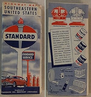
1949 STANDARD OIL COMPANY (INDIANA) SOUTHEASTERN UNITED STATES HIGHWAY MAP
Sprache: Englisch
Verlag: H.M. GOUSHA COMPANY, 1949
Anbieter: ROXY'S READERS, VINCENNES, IN, USA
Verkäuferbewertung 5 von 5 Sternen

Karte
No Binding. Zustand: Fair. No Jacket. Illustrated Edition. 1949 STANDARD OIL COMPANY (INDIANA) HIGHWAY MAP OF SOUTHEASTERN UNITED STATES THIS MAP OPENS UP TO APPROX 18" BY 34". WHEN FOLDED ITS APPROX SIZE IS 4" BY 9". THIS 1949 MAP HAS EDGE WEAR, CORNER CREASES AND SOME DARKENING WITH AGE. THE FOLDS SHOW SOME WEAR BUT THEY ARE INTACT. THERE ARE SOME EDGE TEARS. THE SOUTHEASTERN UNITED STATES MAP SIDE DOES HAVE WRITING ON IT. I DO NOT SEE ANY WRITING ON THE OTHER SIDE (UNITED STATES CANADA MEXICO MAP). PLEASE SEE ALL PICTURES FOR MORE DETAILS.
-

Bowen's Indiana State Atlas, Containing a Separate Map of Each County, Showing Section, Township and Range Lines, Railroad and Interurban Lines, . Sketch of Each County; Improved Roads.
Anbieter: Redux Books, Grand Rapids, MI, USA
Verkäuferbewertung 5 von 5 Sternen
Paperback. Zustand: Good. Paperback. Pages are clean and unmarked. Covers show light edge wear.; 100% Satisfaction Guaranteed! Ships same or next business day!
-

Rand McNally Easy to Fold: Indiana State Laminated Map
Anbieter: Lakeside Books, Benton Harbor, MI, USA
Verkäuferbewertung 5 von 5 Sternen
Zustand: New. Brand New! Not Overstocks or Low Quality Book Club Editions! Direct From the Publisher! We're not a giant, faceless warehouse organization! We're a small town bookstore that loves books and loves it's customers! Buy from Lakeside Books!
-
Bowen's Indiana State Atlas, Containing a Separate Map of Each County, Showing Section, Township and Range Lines, Railroad and Interurban Lines, . Sketch of Each County; Improved Roads.
Anbieter: Books From California, Simi Valley, CA, USA
Verkäuferbewertung 4 von 5 Sternen

paperback. Zustand: Fine.
-

MAP: Road Map: Indiana
Sprache: Englisch
Verlag: H.M. Gousha Company, Chicago IL, 1958
Anbieter: Dorley House Books, Inc., Hagerstown, MD, USA
Verkäuferbewertung 4 von 5 Sternen
Paperback. Zustand: Very Good. Colored Map (illustrator). folded road map.
-

MAP: Road Map: Indiana
Sprache: Englisch
Verlag: H.M. Gousha Company, Chicago IL, 1963
Anbieter: Dorley House Books, Inc., Hagerstown, MD, USA
Verkäuferbewertung 4 von 5 Sternen
Erstausgabe
Paperback. Zustand: Very Good. Colored Map (illustrator). 1st. folded road map.
-

Zustand: very_good. Some light shelf, storage or usage wear present. Pictures available upon request. Individually inspected by Scott. Thanks for supporting an independent bookseller!
-

Flip Map Indiana: Laminated Map
Sprache: Englisch
Verlag: Universal Map, Williamston MI, 2000
ISBN 10: 0762511354 ISBN 13: 9780762511358
Anbieter: THE OLD LIBRARY SHOP, Bethlehem, PA, USA
Verkäuferbewertung 5 von 5 Sternen
Non-book. Zustand: fine. 6-panel double sided laminated color map; can be written in and wiped out. Non-book.
-
INDIANA Highway Map - Standard Oil - 1977
Verlag: Standard Oil, 1977
Anbieter: The Book Scot, Mansfield, MO, USA
Verkäuferbewertung 5 von 5 Sternen
Karte Erstausgabe
Soft cover. Zustand: Very Good. No Jacket. 1st Edition. Folded map about 4 by 9 inches. Opens to about 18 by 28 inches. Printed in color on both sides. Light wear. VERY GOOD.
-
INDIANA Highway Map - Standard Oil - 1973
Verlag: Standard Oil, 1973
Anbieter: The Book Scot, Mansfield, MO, USA
Verkäuferbewertung 5 von 5 Sternen
Karte Erstausgabe
Soft cover. Zustand: Very Good. No Jacket. 1st Edition. Folded map size about 4 by 9 inches. Opens to about 18 by 28 inches. Printed in color on both sides. Light wear. VERY GOOD.
-
INDIANA Highway Map - Standard Oil - 1970
Verlag: Standard Oil, 1970
Anbieter: The Book Scot, Mansfield, MO, USA
Verkäuferbewertung 5 von 5 Sternen
Karte Erstausgabe
Soft cover. Zustand: Very Good. No Jacket. 1st Edition. Folded map size about 4 by 9 inches. Opens to about 18 by 28 inches. Printed in color on both sides. Light wear. VERY GOOD.
-
INDIANA Highway Map - Standard Oil - 1968
Verlag: Standard Oil, 1968
Anbieter: The Book Scot, Mansfield, MO, USA
Verkäuferbewertung 5 von 5 Sternen
Karte Erstausgabe
Soft cover. Zustand: Very Good. No Jacket. 1st Edition. Folded map size about 4 by 9 inches. Opens to about 18 by 24 inches. Printed in color on both sides. Light wear. VERY GOOD.
-

Rand McNally Indiana Easyfinder Map
Anbieter: Half Price Books Inc., Dallas, TX, USA
Verkäuferbewertung 5 von 5 Sternen
map. Zustand: Very Good. Connecting readers with great books since 1972! Used books may not include companion materials, and may have some shelf wear or limited writing. We ship orders daily and Customer Service is our top priority!
-
map. Zustand: Very Good. Connecting readers with great books since 1972! Used books may not include companion materials, and may have some shelf wear or limited writing. We ship orders daily and Customer Service is our top priority!
-

Highway and Drainage Map of Huntington County Indiana 1944
Sprache: Englisch
Verlag: Huntington County, 1944
Erstausgabe
Paperback. Zustand: Fair. 1st Edition. Collectible maps of Huntington County Tight and sound, but fragile Cover is very soiled as pictured Includes fold out map of Huntington Roads No inside markings or underlings The vertical white line on the photo is the fault of my scanner not on the book Please see our photo as some book sites use stock images.
-

National Geographic Magazine February, 1977 with illinois, Indiana, Ohio, and Kentucky map supplement.
Verlag: National Geographic, 1977
Anbieter: BOOKFINDER, inc, Lawndale, NC, USA
Verkäuferbewertung 4 von 5 Sternen
Erstausgabe
Magazine. Zustand: Good. First Edition. this magazine is in Good+ condition. overall, clean, tight and bright. Map Supplement is in Very Good condition. spine top and bottom have small tears. articles include: Longest Manned balloon flight; Audubon on the wing; to live in Harlem; the pageant of rajasthan; river with a job to do -- the Ohio; new microscopes reveal an invisible world. fully illustrated by photographs.
-
National Geographic Map - Close-up: U.S.A. - Illinois, Indiana, Ohio, Kentucky - 1977 (MAP ONLY)
Verlag: National Geographic Society, 1978
unbound. Zustand: Fine. Fast Shipping - Safe and Secure Bubble Mailer!
-
Indiana Floral State Map Sticker
Verlag: Kingdom of Threads, 2026
Anbieter: Fallen Leaf Books, Nashville, IN, USA
Verkäuferbewertung 2 von 5 Sternen

Novelty. Zustand: New.
-
National Geographic map supplement only February, 1977 Close-up U.S.A. Illinois, Indiana, Ohio, Kentucky
Verlag: National Geographic, 1977
Anbieter: BOOKFINDER, inc, Lawndale, NC, USA
Verkäuferbewertung 4 von 5 Sternen
Karte
No Binding. Zustand: Very Good. This wall map is in Very Good condition. Complete and bright. No tears. Originally came as a multi-folded supplement in the National Geographic magazine.
-

Indiana roadmap: Including a detailed map of central Indianapolis
Anbieter: Hawking Books, Edgewood, TX, USA
Verkäuferbewertung 4 von 5 Sternen
Zustand: Good. Good Condition. Please read before purchase: Has severe spine crack - must be read gently - pages still intact. Five star seller - Buy with confidence!
-

Brazil, Indiana, Business and Professional Directory, Street Guide and Official Map, 1935 (Classic Reprint)
Anbieter: PBShop.store US, Wood Dale, IL, USA
Verkäuferbewertung 5 von 5 Sternen
PAP. Zustand: New. New Book. Shipped from UK. Established seller since 2000.
-

The Farm Journal Directory of Shelby County, Indiana : (with a Complete Road Map of the County), 1916; yr.1916
Anbieter: GreatBookPrices, Columbia, MD, USA
Verkäuferbewertung 5 von 5 Sternen
Zustand: New.
-
Bowen's Indiana State Atlas, Containing a Separate Map of Each County, Showing Section, Township and Range Lines, Railroad and Interurban Lines, Churc
Anbieter: GreatBookPrices, Columbia, MD, USA
Verkäuferbewertung 5 von 5 Sternen
Zustand: New.
-

The Farm Journal Directory of Shelby County, Indiana: (with a Complete Road Map of the County), 1916; yr.1916 (Paperback or Softback)
Sprache: Englisch
Verlag: Legare Street Press 9/9/2021, 2021
ISBN 10: 1014558646 ISBN 13: 9781014558640
Anbieter: BargainBookStores, Grand Rapids, MI, USA
Verkäuferbewertung 5 von 5 Sternen
Paperback or Softback. Zustand: New. The Farm Journal Directory of Shelby County, Indiana: (with a Complete Road Map of the County), 1916; yr.1916. Book.
-

Bowen's Indiana State Atlas, Containing a Separate Map of Each County, Showing Section, Township and Range Lines, Railroad and Interurban Lines, Churc (Paperback or Softback)
Sprache: Englisch
Verlag: Legare Street Press 9/10/2021, 2021
ISBN 10: 1015240798 ISBN 13: 9781015240797
Anbieter: BargainBookStores, Grand Rapids, MI, USA
Verkäuferbewertung 5 von 5 Sternen
Paperback or Softback. Zustand: New. Bowen's Indiana State Atlas, Containing a Separate Map of Each County, Showing Section, Township and Range Lines, Railroad and Interurban Lines, Churc. Book.
-
MAP OF DELAWARE COUNTY INDIANA
Verlag: D&N RESEARCH SERVICE, 1989
Anbieter: P.C. Schmidt, Bookseller, Kettering, OH, USA
Verkäuferbewertung 4 von 5 Sternen
Soft Cover. Zustand: Very Good+. Reprint Edition. REPRINT FROM THE 1874 MAP THAT WAS ORIGNIALLY PUBLISHED BY A.L. KINGMAN, BLUE WRAPS, ILLUSTRATED WITH PLATES CHURCHES ,CEMETERIES AND ALL THE NAMES. Size: 11 x 16".
-

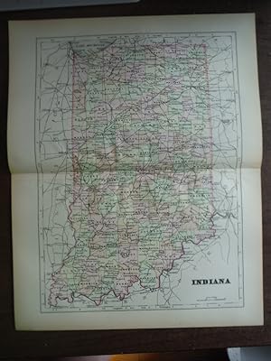
Johnson's Map of Indiana - Original (1895)
Sprache: Englisch
Verlag: A. J. Johnson Company, 1895
Anbieter: Imperial Books and Collectibles, Wauwatosa, WI, USA
Verkäuferbewertung 5 von 5 Sternen
No Binding. Zustand: Fine. This rare original hand colored copper plate engraving of Indiana is from Volume IV of the 1895 edition of the acclaimed Johnson's Universal Cyclopaedia. Cities, towns, roads and rail lines are clearly depicted. . Plate size: - 12" x 10" (30 x 25 cm); Margins: - Min 1/2 in (12.7 mm). Condition: Fine; Central fold as issued.
-
Universal Cyclopaedia and Atlas Map of Indiana - Original (1902)
Sprache: Englisch
Verlag: D. Appleton and Company, 1902
Anbieter: Imperial Books and Collectibles, Wauwatosa, WI, USA
Verkäuferbewertung 5 von 5 Sternen
No Binding. Zustand: Fine. This rare original hand colored map of Indiana is from Volume VI of the 1902 edition of the acclaimed Universal Cyclopaedia and Atlas by D. Appleton and Company. Counties are distinguished by color. Cities, towns, roads and rail lines are clearly depicted. Plate size: - 11" x 9" (28 x 23 cm). Margins: - Min 1/2in (1.2cm). Condition: Fine; central fold as issued.
-

Paperback. Zustand: Very Good. No Jacket. Collectible, nice city map with only minor wear Tight and sound Cover has minor soiling No tears No inside markings or underlinings The white vertical light strip is the fault of my scanner not the book Please see our photo as some book sites may use stock images.