
Gesamtpreis (1 Artikel Artikel):
Versandziel:

plan lima (32 Ergebnisse)
Direkt zu den wichtigsten Suchergebnissen
Suchfilter
Produktart
- Alle Product Types
- Bücher (20)
- Magazine & Zeitschriften (Keine weiteren Ergebnisse entsprechen dieser Verfeinerung)
- Comics (Keine weiteren Ergebnisse entsprechen dieser Verfeinerung)
- Noten (Keine weiteren Ergebnisse entsprechen dieser Verfeinerung)
- Kunst, Grafik & Poster (6)
- Fotografien (Keine weiteren Ergebnisse entsprechen dieser Verfeinerung)
- Karten (6)
- Manuskripte & Papierantiquitäten (Keine weiteren Ergebnisse entsprechen dieser Verfeinerung)
Zustand Mehr dazu
- Neu (14)
- Wie Neu, Sehr Gut oder Gut Bis Sehr Gut (5)
- Gut oder Befriedigend (6)
- Ausreichend oder Schlecht (Keine weiteren Ergebnisse entsprechen dieser Verfeinerung)
- Wie beschrieben (7)
Einband
Weitere Eigenschaften
- Erstausgabe (2)
- Signiert (Keine weiteren Ergebnisse entsprechen dieser Verfeinerung)
- Schutzumschlag (Keine weiteren Ergebnisse entsprechen dieser Verfeinerung)
- Angebotsfoto (25)
- Keine Print-on-Demand Angebote (26)
Sprache (5)
Gratisversand
Land des Verkäufers
Verkäuferbewertung
-

Lonely Planet Peru: Plan the Trip of a Lifetime | Detailed Itineraries & Maps | Insider Tips | Covers Lima, Machu Picchu, the Amazon and more (Travel Guide)
Anbieter: California Books, Miami, FL, USA
Verkäuferbewertung 4 von 5 Sternen

Zustand: New.
-
Lonely Planet Peru: Plan the Trip of a Lifetime | Detailed Itineraries & Maps | Insider Tips | Covers Lima, Machu Picchu, the Amazon and more (Travel Guide)
Anbieter: Ria Christie Collections, Uxbridge, Vereinigtes Königreich
Verkäuferbewertung 5 von 5 Sternen

EUR 21,41
EUR 13,85 Versand
Versand von Vereinigtes Königreich nach USAAnzahl: Mehr als 20 verfügbar
In den WarenkorbZustand: New. In.
-
Lonely Planet Peru: Plan the Trip of a Lifetime | Detailed Itineraries & Maps | Insider Tips | Covers Lima, Machu Picchu, the Amazon and more (Travel Guide)
Anbieter: Gallix, Gif sur Yvette, Frankreich
Verkäuferbewertung 5 von 5 Sternen
Zustand: Neuf.
-

Lonely Planet Peru : Plan the Trip of a Lifetime | Detailed Itineraries & Maps | Insider Tips | Covers Lima, Machu Picchu, the Amazon and more
Anbieter: AHA-BUCH GmbH, Einbeck, Deutschland
Verkäuferbewertung 5 von 5 Sternen
Taschenbuch. Zustand: Neu. Neuware - Lonely Planet's local travel experts reveal all you need to know to plan the trip of a lifetime in this latest edition of our guide to Peru.
-

PEROU - CARTE MICHELIN - 763 NATIONAL - 1/150000 : Index des localités - Sites touristiques - Plan de Lima
Karte
Couverture souple. Zustand: bon. R200093253: NON DATE. In-Plano. Broché. Bon état, Couv. convenable, Dos satisfaisant, Intérieur frais. 1 dépliant d'environ 90*72cm avec 1 carte et 1 plan en couleurs. Léger manque en coin. altérant trčs légčrement la lecture. . . . Classification Dewey : 912-Atlas, cartes et plans.
-

Photographs and Plan of Saint Rose of Lima Church and School, Houston, TX
Verlag: Greenwich: Franklin X. McCormick, 1954
Anbieter: Wittenborn Art Books, San Francisco, CA, USA
Verkäuferbewertung 5 von 5 Sternen
Kunst / Grafik / Poster
Zustand: Good. One leaf on enamel paper. 12 x 15 inches. Views and floor plan of the building. As published in "The Portfolio of Ecclesiastical Designs," Second Edition, 1954.Provenance: Clifford N Wright Architect, Birmingham, MI, with his stamp in the lower right margin.
-

PLAN PILOTO DE LIMA 1949
Sprache: Spanisch
Verlag: Editorial Académica Espańola, 2023
ISBN 10: 6202105704 ISBN 13: 9786202105705
EUR 78,17
EUR 48,99 Versand
Versand von Deutschland nach USAAnzahl: Mehr als 20 verfügbar
In den WarenkorbZustand: New.
-

Plan de negocio : Para una empresa inmobiliaria de departamentos dirigidos al NSE A2 y ubicados en los distritos de la Lima Top
Sprache: Spanisch
Verlag: Editorial Académica Espańola, 2019
ISBN 10: 6139408814 ISBN 13: 9786139408818
Zustand: Hervorragend. Zustand: Hervorragend | Seiten: 388 | Sprache: Spanisch | Produktart: Bücher | Aun cuando el sector inmobiliario viene atravesando por un largo periodo de desaceleración que según expertos estaría llegando a su fin, entre los promotores inmobiliarios de nuestro medio, específicamente aquellos con operaciones en la ciudad de Lima parece haber un consenso en que el negocio inmobiliario representa hoy una oportunidad real para un emprendimiento nuevo. Coinciden también que hoy, más que antes, se requieren habilidades gerenciales y un alto nivel de conocimiento de lo que hay que hacer para no fracasar en el intento. En un contexto en el que las condiciones del macro-entorno, la probada existencia de un mercado potencial y la experiencia del emprendedor favorecerían el emprendimiento propuesto, el presente plan de negocios demuestra que Firenze Inmobiliaria es viable en términos operativos, organizativos y económicos, y que posee las ventajas competitivas que garantizan su sostenibilidad.
-

Plan de negocio | Para una empresa inmobiliaria de departamentos dirigidos al NSE A2 y ubicados en los distritos de la Lima Top
Sprache: Spanisch
Verlag: Editorial Académica Espańola, 2019
ISBN 10: 6139408814 ISBN 13: 9786139408818
Taschenbuch. Zustand: Neu. Plan de negocio | Para una empresa inmobiliaria de departamentos dirigidos al NSE A2 y ubicados en los distritos de la Lima Top | Adolfo Martín Granadino Arana | Taschenbuch | 388 S. | Spanisch | 2019 | Editorial Académica Espańola | EAN 9786139408818 | Verantwortliche Person für die EU: Editorial Academica Espanola, Brivibas Gatve 197, 1039 RIGA, LETTLAND, customerservice[at]vdm-vsg[dot]de | Anbieter: preigu.
-

PLAN PILOTO DE LIMA 1949 | PRIMER PLAN PILOTO DE LA MODERNIDAD URBANÍSTICA INTERNACIONAL
Sprache: Spanisch
Verlag: Editorial Académica Espańola, 2023
ISBN 10: 6202105704 ISBN 13: 9786202105705
Taschenbuch. Zustand: Neu. PLAN PILOTO DE LIMA 1949 | PRIMER PLAN PILOTO DE LA MODERNIDAD URBANÍSTICA INTERNACIONAL | Robinson Ortiz | Taschenbuch | Spanisch | 2023 | Editorial Académica Espańola | EAN 9786202105705 | Verantwortliche Person für die EU: preigu GmbH & Co. KG, Lengericher Landstr. 19, 49078 Osnabrück, mail[at]preigu[dot]de | Anbieter: preigu.
-
Plan de negocio: Para una empresa inmobiliaria de departamentos dirigidos al NSE A2 y ubicados en los distritos de la Lima Top
Sprache: Spanisch
Verlag: Editorial Académica Espańola, 2019
ISBN 10: 6139408814 ISBN 13: 9786139408818
Anbieter: Revaluation Books, Exeter, Vereinigtes Königreich
Verkäuferbewertung 5 von 5 Sternen
EUR 168,68
EUR 14,45 Versand
Versand von Vereinigtes Königreich nach USAAnzahl: 1 verfügbar
In den WarenkorbPaperback. Zustand: Brand New. 388 pages. Spanish language. 8.82x6.26x1.10 inches. In Stock.
-
![Bild des Verkäufers für Recreation survey and long-range plan for the city of Lima, Ohio Prepared for the Mayor, City council and the Board of Education, by the Recreation Board, under the direction of W.C. Batchelor. 1951 [LeatherBound] zum Verkauf von S N Books World](https://pictures.abebooks.com/inventory/md/md31650139696.jpg)
LeatherBound. Zustand: New. BOOKS ARE EXEMPT FROM IMPORT DUTIES AND TARIFFS; NO EXTRA CHARGES APPLY. Leatherbound edition. Condition: New. Leather Binding on Spine and Corners with Golden leaf printing on spine. Bound in genuine leather with Satin ribbon page markers and Spine with raised gilt bands. Pages: 114. A perfect gift for your loved ones. Reprinted from 1951 edition. NO changes have been made to the original text. This is NOT a retyped or an ocr'd reprint. Illustrations, Index, if any, are included in black and white. Each page is checked manually before printing. As this print on demand book is reprinted from a very old book, there could be some missing or flawed pages, but we always try to make the book as complete as possible. Fold-outs, if any, are not part of the book. If the original book was published in multiple volumes then this reprint is of only one volume, not the whole set. IF YOU WISH TO ORDER PARTICULAR VOLUME OR ALL THE VOLUMES YOU CAN CONTACT US. Resized as per current standards. Sewing binding for longer life, where the book block is actually sewn (smythe sewn/section sewn) with thread before binding which results in a more durable type of binding. Language: English Pages: 114.
-
Carte originale entoilee.Carte Particuliere du Perou,Plan de la Ville de Lima,Description de quelques Plantes,Animaux, & Machines du Pays.Avec l'Habillement des Hommes & des Femmes Espagnoles qui y Demeurent
Sprache: Französisch
Verlag: Chez L'Honore & Chatelain,libraires, A Amsterdam, 1719
Couverture souple. Zustand: Trčs bon. 2čme Édition. Francais.Une petite fissure au centre du texte.Petits manques sur la peripherie du papier.CARTE ORIGINALE ENTOILEE avec Carte,Plan,Illustrations et Texte . De format 45,5 x 51 cm plus entoilage.Faisant partie de "Atlas Historique,Tome 6 ".Poids 500 gr.(La page de titre n 'est pas en vente).
-
![Bild des Verkäufers für Plan de la Ville de Lima oů des Rois Capitale du Perou [Plano de la ciudad de Lima] zum Verkauf von Bolivar Old Prints Anticuario](https://pictures.abebooks.com/inventory/md/md32181238914.jpg)
Plan de la Ville de Lima oů des Rois Capitale du Perou [Plano de la ciudad de Lima]
Verlag: Paris, 1764
Anbieter: Bolivar Old Prints Anticuario, Barcelona, B, Spanien
Verkäuferbewertung 5 von 5 Sternen
Karte
Zustand: Bueno. 21 x 34,5cm. Plano detallado de la ciudad de Lima del ańo 1764. El mapa se extiende a lo largo del centro histórico de la ciudad. El mapa se publicó en Paris en el ańo 1764 por Jacques Nicolas Bellin quien fue un cartógrafo e hidrógrafo francés, reconocido por su trabajo en la cartografía náutica. Fue el cartógrafo principal del Dépôt des cartes et plans de la Marine y produjo numerosos mapas detallados de costas y territorios coloniales franceses. Entre sus obras más importantes destacan el "Atlas Maritime" (1764) y el "Petit Atlas Maritime" (1764), que contenían mapas precisos de América, África y Asia. Sus trabajos fueron utilizados por navegantes y exploradores, consolidando su prestigio en la cartografía del siglo XVIII. Bellin se destacó por la precisión y calidad de sus mapas, los cuales influenciaron la cartografía europea. En cuanto al mapa, vemos como la ciudad se encuentra en proceso de expansión puesto que hay espacios aún por construir incluso dentro del muro. Hablando del muro, podemos ver que en aquella época gran parte de la ciudad se encontraba protegida en el sur, este y oeste por una muralla. En cambio, la zona norte encontramos el antiguo cauce del "Río de Lima", que corresponde al actual llamado Río Rímac, así como la propia montańa que hacen de muralla natural. En la parte derecha del mapa vemos la leyenda en francés. Esta destaca diferentes puntos interesantes de la ciudad entre los que se encuentran el Palacio del Virrey, La Catedral, el Ayuntamiento y el hospital. En la parte superior izquierda vemos el título junto con la escala. Ambos rodeados por una elegante cartela. dimensiones del mapa son de 21 x 34.5cm Condición Muy buena, con alguna marca de plegado.Plan de la Ville de Lima oů des Rois Capitale du Perou.Palabras clave: "Perú", "Lima", "Plano", "Río Rímac". Idioma: Francés.
-
![Bild des Verkäufers für [Mapa de Lima, Perú] Carte particuliere du Perou, Plan de la Ville de Lima zum Verkauf von Bolivar Old Prints Anticuario](https://pictures.abebooks.com/inventory/md/md31791599741.jpg)
[Mapa de Lima, Perú] Carte particuliere du Perou, Plan de la Ville de Lima
Verlag: Ámsterdam, 1721
Anbieter: Bolivar Old Prints Anticuario, Barcelona, B, Spanien
Verkäuferbewertung 5 von 5 Sternen
Karte
Sin Encuadernar. Zustand: Bueno. Interesante grabado antiguo que contiene un mapa de la costa noroeste de Sudamérica y que abarca desde Panamá hasta el extremo norte de Chile incluyendo los actuales territorios de Colombia, Ecuador y Perú. A los lados de este mapa, un par de grabados representan elementos de la flora y fauna de la región, herramientas y maquinaria, y la vestimenta de los espańoles que ahí habitan. Abajo un plano de la ciudad de Lima con su traza reticular y su sistema de murallas. Los acompańa un texto explicativo en francés. Este grabado original fue publicado en el afamado Atlas Historique de Henri Abraham Chatelain (1684-1743). Chatelain fue un pastor hugonote de origen parisino. Fue un exitoso hombre de negocios que creó redes muy lucrativas en Londres, La Haya y Ámsterdam. Su obra más famosa fue el Atlas Historique, publicado en siete volúmenes entre 1705 y 1720. Este monumental trabajo se enfocó en la historia y genealogía de los continentes, abordando temas como la geografía, cosmografía, topografía, heráldica y etnografía. Los mapas incluidos fueron hechos por Chatelain y estuvieron basados en el trabajo de Guillaume Delisle. 49 x 37.5 cm. FRA. Very good.
-
![Bild des Verkäufers für Plan a que los concurrentes a las conferencias de jurisprudencia teorico-practica establecidas conforme a los estatutos del ilustre Colegio de Abogados de Lima deben arreglar sus estudios : para su mas facil instruccion, formado por encargo de la junta particular del mismo ilustre Colegio 1818 [LeatherBound] zum Verkauf von True World of Books](https://pictures.abebooks.com/inventory/md/md31533654365.jpg)
Plan a que los concurrentes a las conferencias de jurisprudencia teorico-practica establecidas conforme a los estatutos del ilustre Colegio de Abogados de Lima deben arreglar sus estudios : para su mas facil instruccion, formado por encargo de la junta particular del mismo ilustre Colegio 1818 [LeatherBound]
Erscheinungsdatum: 2025
Anbieter: True World of Books, Delhi, Indien
Verkäuferbewertung 5 von 5 Sternen
LeatherBound. Zustand: New. BOOKS ARE EXEMPT FROM IMPORT DUTIES AND TARIFFS; NO EXTRA CHARGES APPLY. Leather Binding on Spine and Corners with Golden leaf printing on spine. Bound in genuine leather with Satin ribbon page markers and Spine with raised gilt bands. A perfect gift for your loved ones. Reprinted from 1818 edition. NO changes have been made to the original text. This is NOT a retyped or an ocr'd reprint. Illustrations, Index, if any, are included in black and white. Each page is checked manually before printing. As this print on demand book is reprinted from a very old book, there could be some missing or flawed pages, but we always try to make the book as complete as possible. Fold-outs, if any, are not part of the book. If the original book was published in multiple volumes then this reprint is of only one volume, not the whole set and contains approximately 24 pages. IF YOU WISH TO ORDER PARTICULAR VOLUME OR ALL THE VOLUMES YOU CAN CONTACT US. Resized as per current standards. Sewing binding for longer life, where the book block is actually sewn (smythe sewn/section sewn) with thread before binding which results in a more durable type of binding. Language: Spanish.
-
[Südamerika:] Fünfzehn Jahre in Süd-Amerika an den Ufern des Stillen Oceans. Gesehenes und Erlebtes. Band I: Mit 8 Bildern, einem gefalteten Plan von Valparaiso und einer gefalteten Karte von Chile, nach theils eigenen Aufnahmen des Verfassers. Band II: Mit 15 Bildern und einer gefalteten Karte des Indiandergebiets zwischen den Flüssen Valdivia und Tolten von 1860 in Lichtdruck. Band III: Mit 15 Bildern und einer gefalteten Karte der Umgegend von Lima, des Hauptschauplatzes des letzten Krieges zwischen den Chilenen und Peruanern, in Lichtdruck. 3 Bände, gebunden in einem Band.
Sprache: Deutsch
Verlag: Weltpost-Verlag Richard Lesser, Leipzig, 1882
Anbieter: Antiquariat Rolf Bulang, Dautphetal, Deutschland
Verkäuferbewertung 5 von 5 Sternen
Erstausgabe
Hardcover. Zustand: Gut. Erste Ausgabe. 2 Blatt, 232 S.; 2 Blatt, 184 S.; 1 Blatt, 208 S. Neuerer Halbleinenband. Der Geologe und Bergbauunternehmer Paul Treutler (1822-1887) verlor nach siebenjähriger Tätigkeit in Chile während der dortigen Revolution sein Vermögen und durchstreifte anschließend das noch wenig bekannte Gebiet der Araukaner in der Provinz Valdivia. Insgesamt unternahm er 1859-64 vier Expeditionen und lieferte neben seiner groben topographischen Karte vor allem wichtige neue Aufschlüsse über die Lebensart und den kriegerischen Geist dieses Stammes der indigenen Ureinwohner (heute meist als Mapuche bezeichnet) (Henze V, 345). Nicht bei Sabin. Ein gut erhaltenes Exemplar mit nur leichten Gebrauchsspuren.
-

Plan of Lima
Erscheinungsdatum: 1770
Anbieter: Antipodean Books, Maps & Prints, ABAA, Garrison, NY, USA
Verbandsmitglied: ABAA ANZAAB ESA ILAB
Verkäuferbewertung 4 von 5 Sternen
Zustand: Very good condition. A copper engraving of the city layout of Lima, and the Port of Callao below. At lower margin are numbered images describing the Llama, Vicogn, Huanaco, Calash used at Lima, Mestizo woman on horseback, Lady of Lima, Spaniard in Peruvian dress, Lady of Lima in riding dress, Mulatto woman and a Negro servant. Plate VI, page 30 from an unknown book. 8 x 10 5/8", original folds, slt offsetting marks, otherwise very clean.
-
Plan of Lima, Peru
Verlag: Paris, 1746
Anbieter: Trillium Antique Prints & Rare Books, Franklin, TN, USA
Verkäuferbewertung 3 von 5 Sternen

Kunst / Grafik / Poster
Zustand: Fine. This fine engraving is from Antoine-Francois Prevost d'Exiles's Histoire GĂ nĂ rale des Voyages, ou nouvelle collection de toutes les relations de voyages par mer et par terre, qui ont Ă tĂ publiĂ es jusqu'Ă present dans les diffĂ rentes langues de toutes les nations connues. The work was published by Chez Didot in Paris in 1746. The plates and maps were by Cochin fils, Tardieu, B. L. Prevost and others.It was an expansive work that referenced China, the East Indies, Asia, the Americas, early Austrlian voyages, New Guinea, Palau Islands, Africa, and voyages in the Pacific including those of Magellan, Schouten, and Le Maire, Drake, Sarmiento, Cavendish, Spilbergen, Narborough, Rogers, Cowley, Frazier, and Anson. The work included particularly full accounts are given of the Dutch and French voyages to the East Indies, voyages to China, and the British East India Company's voyages to India and Ceylon. (Hill) --- Overall Very Good to Excellent. There can be some very light image or text offset with this work. There may be a few minor imperfections to be expected with age. Please review the image carefully for condition and contact with any questions.
-

Carte particuliere du Perou, plan de la ville de Lima, description de quelques plantes, animaux, & machines du pays avec l'habillement des hommes & des femmes Espagnoles qui y demeurent
Verlag: Perů
Anbieter: Sergio Trippini, Gavirate, VA, Italien
Verkäuferbewertung 4 von 5 Sternen
Carta geografica, antica ed originale, inserita nel VI Tomo "Atlas Historique ou nouvelle introduction a l'Histoire, ŕ la Chronologie & ŕ la Geographie Ancienne & Moderne?", pubblicato ad Amsterdam nel 1719. Atlante che, con la sua pubblicazione, coniuga le mappe geografiche con incisioni e informazioni di carattere geografico, araldico, etnografico e storico cosě rendendo l'opera in sette volumi molto innovativa. Incisione in rame 490x375 mm.Henri Abraham Chatelain (1684 - 1743), pastore ugonotto originario di Parigi visse alternativamente a Parigi, Londra, L'Aia ed Amsterdam. Conosciuto come cartografo olandese per il sua opera cartografica monumentale in sette volumi "Atlas Historique" pubblicata ad Amsterdam con i suoi fratelli. Mappa con vedute del Perů e della costa nord-occidentale del Sud America che si estende da Panama al Cile. Vengono mostrate cittŕ, fiumi, laghi e catene montuose. Pianta della cittŕ di Lima con le sue fortificazioni. Le altre vignette mostrano piante e animali indigeni e persone della regione. Include testo descrittivo.
-

Plan Scenographique de la Cite des Rois ou Lima Capitale du Royaume de Perou
Verlag: Bellini, 1760
Anbieter: Chaco 4ever Books, Montevideo, MO, Uruguay
Verkäuferbewertung 5 von 5 Sternen
Karte
Sin Encuadernar. Zustand: Muy bien. 190x315 mm. Black & White.
-

Map of Peru & Equador, Plan of Lima, Views of South America
Verlag: Amsterdam, 1718
Anbieter: Trillium Antique Prints & Rare Books, Franklin, TN, USA
Verkäuferbewertung 3 von 5 Sternen
Kunst / Grafik / Poster Erstausgabe
Zustand: Fine. This originally hand-colored engraving is from Henri Abraham Chatelain's Atlas Historique. The work was published by the author in Amsterdam between 1718 and 1720.The text was compiled by Gueudeville & Garillon. The maps were completed by Chatelain with some influenced by Guillaume de l'Isle's work.The work was published in several editions with the second edition the first to include additional maps not found in the first including a map of the world, Americas, Europe, Asia, and Africa. These engravings come from mixed editions. Those from volumes 5 to 7 are first edition. The engravings from volumes 1 to 4 are from early ediitons.Atlas Historique was a highly ambitious and groundbreaking work covering genealogy, cosmography, topography, heraldry, and chronology. It was intended for the general public and the increased fascination with the recently conquered colonies and the new discoveries. Chatelain's maps are an outstanding example of the golden age of French mapmaking. --- The work is in good to excellent condition overall. There can be occasional offset, toning, or some separation to fold out plates. There may be a few minor imperfections or faint marks to be expected with age. Please review the image carefully for condition and contact us with any questions. --- Paper Size ~ 16 1/2 - 17 1/4" by 22" (Fold Out).
-

Plan Scenographique de la citË des Rois ou Lima capitale du Royaume de Perou.
Verlag: LíAia, 1750
Anbieter: libreria antiquaria perini Sas di Perini, Verona, VR, Italien
Verkäuferbewertung 5 von 5 Sternen
Kunst / Grafik / Poster
Incisione in rame, mm 200x310, dipinta a mano. Tratta da ěHistoire Generale des Voyagesî nella nuova ed aggiornata edizione di BELLIN & PREVOST, editata il 1747 ed il 1788 ca. edita in Olanda. Ottime condizioni, pieghe editoriali. Nr.cat: Cod 3341.
-

Plan De La Ville De Lima ou Des Rois Capitale du Perou.
Verlag: 1762-1764., Paris, 1762
Anbieter: Alexandre Antique Prints, Maps & Books, Toronto, ON, Kanada
Verkäuferbewertung 5 von 5 Sternen
Karte
Zustand: Very Good. Map of Lima, capital of Peru., Size : 229x365 (mm), 9.02x14.37 (Inches), Hand Colored.
-

Plan Scenographique de la Cite des Rois ou Lima Capitale du Royaume de Perou
Verlag: Paris, 1748
Anbieter: Alexandre Antique Prints, Maps & Books, Toronto, ON, Kanada
Verkäuferbewertung 5 von 5 Sternen
Karte
Zustand: Excellent. Size : 190x315 (mm), 7.5x12.375 (Inches), Black & White.
-
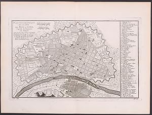
Plan scénographique de la Cité des Rois ou Lima, Capitale du Royaume de Perou. (Peru / Südamerika / South America)
Anbieter: Antiquariat Martin Barbian & Grund GbR, Saarbruecken, Deutschland
Verkäuferbewertung 5 von 5 Sternen
Kunst / Grafik / Poster
Kupferstich von N. Bellin, 1772, 19x31 cm (Faltspuren) *Auf Wunsch senden wir natürlich gerne ein Foto per e-mail zu.
-

Stadtplan ('Plan Sénographique De La Cité Des Rois ou Lima, Capitale du Royaume De Perou. - Scenographischer Abriss Von Der Stadt dea los Reyes (Koenigsstadt) oder Lima, Hauptstadt in dem Koenigreiche Peru.').
Sprache: Deutsch
Anbieter: Antiquariat Norbert Haas, Bedburg-Hau, Deutschland
Verkäuferbewertung 5 von 5 Sternen
Kunst / Grafik / Poster
kolorierter Kupferstich v. Frans de Bakker aus Voyage historique de l'amerique meridionale, 1752, 19,5 x 36,5.
-

PLAN DE LA VILE DE LIMA Capitale du Perou.
Anbieter: Librería Anticuaria Galgo, Oviedo, O, Spanien
Verkäuferbewertung 4 von 5 Sternen
Plano realizado por Frezier en que se ve en detalle la ciudad de Lima en el siglo XVIII con el listado de los lugares más importantes así como las iglesias y capilla. Medidas de la huella: 30x20. Publicado en la Relation du Voyage de la mer du Sud aux côtes du Chily et du Perou de Amédée-François Frezier publicado en París en 1732.
-

PLAN PILOTO DE LIMA 1949
Sprache: Spanisch
Verlag: Editorial Académica Espańola Mai 2023, 2023
ISBN 10: 6202105704 ISBN 13: 9786202105705
Anbieter: BuchWeltWeit Ludwig Meier e.K., Bergisch Gladbach, Deutschland
Verkäuferbewertung 5 von 5 Sternen
Taschenbuch. Zustand: Neu. This item is printed on demand - it takes 3-4 days longer - Neuware -El Plan Piloto de Lima significa un antes y un después en la planificación urbana nacional. Los siguientes planes oficiales realizados, tanto a nivel nacional como a nivel metropolitano parten de él. Los profesionales que aquí laboraron y lo defendieron son los que se encargarán de la elaboración de los siguientes planes a nivel nacional, entre ellos Gastelumendi y Luis Miró Quesada. Siendo el primer intento de planificación integral de la ciudad de Lima, el PPL pone al Perú en el mapa fundacional de la urbanística y el planeamiento moderno, al ser el primer plan oficial de la modernidad racionalista-funcionalista, realizado bajo el formato de la Carta de Atenas y los CIAM (más la quinta función: centro cívico), en darse a conocer en el mundo. Se realizó para una gran ciudad en su totalidad, como encargo oficial y se aprobó oficialmente. Además, se pone en ejecución los lineamientos aprobados del PPL, especialmente en lo que respecta al sistema arterial, el cual deja una profunda huella en la estructura urbana de la ciudad. Es el primer instrumento de gestión de la modernidad urbanística funcionalista-racionalista inspirada en la Carta de Atenas que se ejecuta en el mundo. 368 pp. Spanisch.
-

Plan de negocio : Para una empresa inmobiliaria de departamentos dirigidos al NSE A2 y ubicados en los distritos de la Lima Top
Sprache: Spanisch
Verlag: Editorial Académica Espańola, 2019
ISBN 10: 6139408814 ISBN 13: 9786139408818
Anbieter: AHA-BUCH GmbH, Einbeck, Deutschland
Verkäuferbewertung 5 von 5 Sternen
Taschenbuch. Zustand: Neu. nach der Bestellung gedruckt Neuware - Printed after ordering - Aun cuando el sector inmobiliario viene atravesando por un largo periodo de desaceleración que según expertos estaría llegando a su fin, entre los promotores inmobiliarios de nuestro medio, específicamente aquellos con operaciones en la ciudad de Lima parece haber un consenso en que el negocio inmobiliario representa hoy una oportunidad real para un emprendimiento nuevo. Coinciden también que hoy, más que antes, se requieren habilidades gerenciales y un alto nivel de conocimiento de lo que hay que hacer para no fracasar en el intento. En un contexto en el que las condiciones del macro-entorno, la probada existencia de un mercado potencial y la experiencia del emprendedor favorecerían el emprendimiento propuesto, el presente plan de negocios demuestra que Firenze Inmobiliaria es viable en términos operativos, organizativos y económicos, y que posee las ventajas competitivas que garantizan su sostenibilidad.

![Bild des Verkäufers für [Südamerika:] Fünfzehn Jahre in Süd-Amerika an den Ufern des Stillen Oceans. Gesehenes und Erlebtes. Band I: Mit 8 Bildern, einem gefalteten Plan von Valparaiso und einer gefalteten Karte von Chile, nach theils eigenen Aufnahmen des Verfassers. Band II: Mit 15 Bildern und einer gefalteten Karte des Indiandergebiets zwischen den Flüssen Valdivia und Tolten von 1860 in Lichtdruck. Band III: Mit 15 Bildern und einer gefalteten Karte der Umgegend von Lima, des Hauptschauplatzes des letzten Krieges zwischen den Chilenen und Peruanern, in Lichtdruck. 3 Bände, gebunden in einem Band. zum Verkauf von Antiquariat Rolf Bulang](https://pictures.abebooks.com/inventory/md/md30951222743.jpg)
