Beschreibung
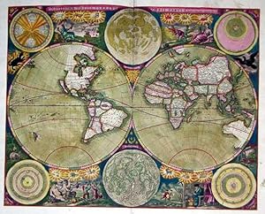
4 volumes. Folio (21 4/8 x 14 inches). Letterpress title-pages, two printed in red and black and with small engraved vignettes, letterpress in volume one ruled in red throughout. Fine engraved portrait of Charles II, engraved by R. White, in volume one by (laid down on heavier stock at an early date) and double-engraved plate of Laplanders by F. van den Houe with magnificent original hand-colour in full, 3 further folding plates and 166 double-page maps of the world by John Seller and Janssonius and Northern Europe, all with original hand-colour in part, the cartouches with original hand-colour in full, those in volume one occasionally HEIGHTENED IN GOLD and gum arabic, all cartouches and other fine details in volume IV HEIGHTENED IN GOLD and gum arabic, all maps in this volume ruled in red (world map by Seller trimmed and laid down on heavier stock, volume one without map 35 'Ducatus Stomariae' and 40 'Regni Norvegiae'; map 35 in volume II 'Marchia Vetus' trimmed and laid down on heavier stock; volume III with maps 'Totius Sveviae', 'Walachia' and 'Iuliacensis Ducatus' trimmed and laid down, without map 126 'Diocesis Leodeniensi' but with additional map 'Oldenburg'; volume IV lacking map 141 'Fossa Eugeniana' but with additional map 'Namurcum Comitatus'). Fine contemporary blind paneled smooth and mottled calf, the spines in 8 compartments with 7 raised bands, one lettered in gilt, the others decorated with fine gilt tools (expertly rebacked preserving the original backstrips, a bit rubbed). Provenance: with the engraved armorial bookplate of George Tollet Esq. (d. 1719), mathematician and naval administrator, on the verso of each title-page; with the engraved armorial bookplate of the Weston Library of the Earls of Bradford on each front paste-down. First edition. The two world maps are John Seller's "Novissima Totius Terrarum Orbis Tabula." (Shirley 460) and Pieter van den Keere's "Nova totius terrarum orbis geographica ac hydrographica tabula" in the revised Janssonius, post 1620, state (Shirley 504) with a dedication to the Bishop of Oxford in the upper left. The map of the North Pole is Janssonius's "Nova et accurata Poli Arctici" and not that of Moses Pitt. The remaining maps are of Northern and Eastern Europe, all based on Dutch cartography, as Pitt's intention had been to publish a mammoth atlas to rival that of Blaeu, "giving a reprise to many of the plates which Janssonius had acquired over the years, some of them going as far back as the stocks that were used for Mercator's Atlas" (Goss) . However, as with many grand publishing designs the venture faltered after only these four volumes. The maps in volume one, in addition to the world map, and that of the Arctic, are of Russia, Poland, and Scandinavia; volumes II and III are of the German Empire; and IV contains the Seventeen Provinces of the Low Countries, or Netherlands. Moses Pitt was neither a cartographer nor a scholar, yet in 1670 he undertook a project that came to be called 'The English Atlas'. Despite the seemingly difficult, if not unrealistic, task at hand--hardly mitigated by the paucity of skilled commercial cartographers in England--Pitt's endeavor was backed by Sir Christopher Wren and Robert Hooke, and his partners included the Dutch map publisher Jan Jansson and the Englishman Steven Stewart. Based on the concept of the Atlas Maior by Joan Blaeu ,Pitt's atlas was to consist of twelve volumes, but only four were completed (covering places "next to the North-pole," Muscovy, Poland, Sweden, Denmark, Germany and the seventeen provinces of the Low Countries). Pitt had envisioned the project as a reissue of a Dutch atlas in "English guise"--in which existing Dutch maps would be repackaged with accompanying text in English--whereas his partners envisioned the printing of an atlas with entirely new maps. Such conflicts, along with economic factors and the overly ambitious nature of the project envisioned, eventually led to its demise. After only four parts. Bestandsnummer des Verk�ufers 000459
Verk�ufer kontaktieren
Diesen Artikel melden
